Ecoregions of Anguilla
Contents
Leeward Islands xeric scrub
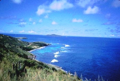
St Croix, US Virgin Islands, USA. Photograph by Tundi Agardy
The historical preoccupation with forests and present-day concern for tropical rain forests has diverted attention from other vegetation of equally deserving botanical merit. Ecoregions such as this Leeward Island Xeric Scrub area are home to numerous endemic plant and animal species making it regionally important for biodiversity. However, due to the proximity to high population centers and often small land area, it suffers from problems such as agricultural encroachment, land alteration associated with mining, loss of trees to charcoal burning, infrastructure to accommodate population increases and tourism, and introduced animals and plants.
Location and General Description
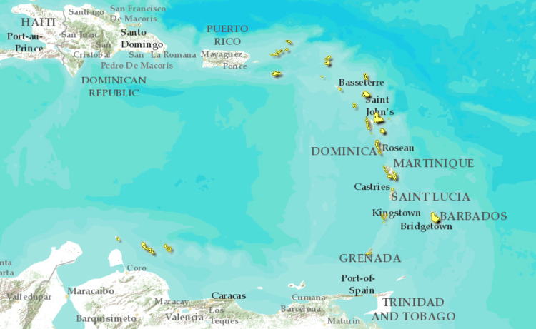 Caribbean shrubland ecoeregion which includes the Leeward Islands xeric scrub. (WWF)
This ecoregion covers much of the land area on most of the Caribbean’s Leeward Islands. This ecoregion is characterized by low elevation, little rainfall and an arid climate. It is found either as a coastal band or in the case of islands such as Anguilla and Antigua, it encompasses nearly the entire island. More specifically, it covers most of Grande Terre and Marie-Galante of Guadeloupe, Antigua, Anguilla, St. Martin, St. Barthelemy, Saba, and the eastern portions of the US Virgin Islands and British Virgin Islands.
The Leeward Islands are found north of the Windward Islands extending to just east of the Virgin Islands between latitudes 15° 45' N to 18° 35' N and longitudes 61° 45' W to 63° 20' W. All of the Leeward Islands lie within the trade-winds belt resulting in a subtropical climate. Islands with sufficient relief receive adequate rainfall, but those with a more subdued topography tend to be dry to semi-arid. The main hurricane track passes through these islands.
The Leeward Islands exhibit two geologically distinct belts. The island of Guadeloupe marks the southern end of the two belts and embodies characteristics of both. The eastern half of Guadeloupe is called Grande Terre and is composed entirely of limestone overlying older andesitic and dacitic volcanics. Basse Terre, the western half, is dominated by Soufriere, a 1,467-meter high active volcano. The inner belt or arc of islands is volcanic in origin and tends to have higher, more rugged topography. These include Monserrat, Nevis, St. Christopher, St. Eustatius, and Saba. Andesitic flows, pyroclastic units, and volcanoclastics of recent to Eocene age dominate this belt. These volcanics are interbedded with Pliocene and Pleistocene limestones on some islands, notably on St. Eustatius, St. Christopher, and Monserrat. Formiferal or oolitic limestone underlies the remaining islands in the outer belt or arc of islands including Guadeloupe's offshore islands of Marie Galante and Desirade, Antigua, Barbuda, St. Barthelemy, St Martin, and Anguilla.
The vegetation of this ecoregion is seral in character, ranging from herbaceous strand vegetation to scrublands, savannas and littoral woodland. The extent and development of vegetation along the beaches depends on the width and elevation of the beach and the extent of interference by man. Many of what were former cotton and sugar cane fields now are occupied by various combinations of Acacia nilotica, A. lutea, A. tortuosa, or A. farnesiana. Forests that were exploited for charcoal production are now characterized by Bursera spp. and Pisonia fragrans. The savannas are characterized by species such as Prosopis chilensis, Acacia spp., and Psidium guava.
Biodiversity Features
Simplified ecosystems, such as those that exist on the islands of this ecoregion, stimulate evolution that results in higher percentages of endemic organisms. Endemics however, rarely possess large [[population]s] and therefore are more susceptible to extirpation. The amount of diversity and number of island endemics in the Lesser Antilles is related to island size, diversity of habitat, and distance from the mainland or another island. Thus, larger islands such as those from Guadeloupe and south into the Windward islands have relatively high diversity and a higher degree of endemic flora and fauna. Examples of this can be seen in the diversity of herpetofauna on different islands within this ecoregion. Saba, the smallest island in this ecoregion, is home to only one amphibian species (Eleutherodactylus johnstonei) and only one endemic lizard (Anolis sabanus). In contrast, Grande Terre of Guadeloupe has the most diverse amphibian fauna in the Lesser Antilles.
The primary negative impact on all forms of wildlife in most Caribbean islands including this ecoregion, has been habitat reduction via the conversion from forested wildlands to other types of land uses. Only remnant patches of pre-colonial vegetation exist. Most current vegetation is secondary growth or vegetation typical of more frequent disturbance.
Bats are the most common native mammals found in this ecoregion. All other extant mammals have been introduced by previous settlers. Common among these are mongooses (Herpestes auropunctatus), goats (Capra hircus), agouti (Dasyprocta agouti), fallow deer (Dama dama) to provide game, and the ubiquitous rodents (Rattus rattus, R. norvegicus and Mus musculus).
Current Status
This ecoregion is distributed over a large geographic area with numerous governmental agencies overseeing local conservation and management. Therefore, the condition and status of different locations within this ecoregion vary significantly depending on the history of agricultural cultivation, population growth, conservation management, etc.
On islands such as the US and British Virgin Islands, large portions are encompassed by this xeric ecoregion. Nineteen percent (6,623 hectares (ha)) of the total land area in the USVI is considered a protected area. The protected areas include the Virgin Islands Biosphere Reserve which has produced a significant number of scientific studies regarding the local flora and fauna. Terrestrial parks in the British Virgin Islands (BVI) cover 2.1% of the land area. The BVI park system plan sought to define a system of parks and protected areas that would incorporate the existing parks into a larger system of comprehensive ecological units in order to preserve the most important areas of natural and cultural heritage. Twelve additional parks were proposed, but none of these has yet been declared. This is partly due to the approach adopted in the BVI of preparing management plans and strengthening institutions in advance of park declaration. Similarly, Guadeloupe, as an Overseas Department of France, has the necessary funding and infrastructure to address current conservation concerns. Guadeloupe has the same legislation as France in terms of the establishment of national parks and reserves. The Direction de la Protection de la Nature is responsible for regulating hunting, conducting research on fauna and flora and administering parks and preserves.
Types and Severity of Threats
The clearing of hillside trees and scrub for the construction of roads and building sites has resulted in severe soil erosion. Uncontrolled and illegal beach sand mining along parts of this ecoregion, in conjunction with uncontrolled sewage disposal from beachfront hotels calls attention to the need for stringent resource regulation and resource conservation measures.
The abandonment of sugar and cotton production on a number of islands in this ecoregion has led to a large increase in livestock production, especially of cattle. Owners of small ruminants (sheep and goats) typically allow their animals to range freely regardless of land ownership. On several of the dry sloped hillsides of this ecoregion, goats are the main agents of deforestation, leading to soil erosion and run-off. More recently, intensive tourism development has resulted in major bio-physical alterations to the coastline and destruction of coastal habitats that represent important components of this ecoregion.
Hunting in France is regarded as a legacy of the French Revolution and in Guadeloupe, is strongly defended by an ever-increasing lobby. A great deal of damage is caused by hunters whose activities are neither organized nor controlled. Hunting takes place during the breeding season of certain species such as pigeons, and there are no bag limits or hunting records. Even some protected species are illegally hunted.
Justification of Ecoregion Delineation
The xeric scrub ecoregion of the Leeward Islands were designated according to CCA survey reports. In order to maintain our broad scale coverage we lumped the cactus scrub terrestrial life zones from all of the Leeward Island which contained this habitat type. Littoral vegetation was also included, when bordering cactus scrub formations.
| Disclaimer: This article contains information that was originally published by the World Wildlife Fund. Topic editors and authors for the Encyclopedia of Earth have edited its content and added new information. The use of information from the World Wildlife Fund should not be construed as support for or endorsement by that organization for any new information added by EoE personnel, or for any editing of the original content. |