British Virgin Islands
| Topics: |
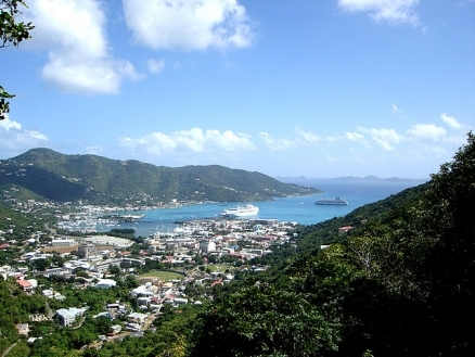
Road Town, Tortola, BVI - 2005. Source: Henry A-W/Wikimedia Commons
Countries and Regions of the World Collection  The British Virgin Islands (often referred to as "BVI") is an overseas territory of the United Kingdom between the Caribbean Sea and the North Atlantic Ocean, east of Puerto Rico. It is composed of 16 inhabited and more than 20 uninhabited islands with just over 25,000 people.
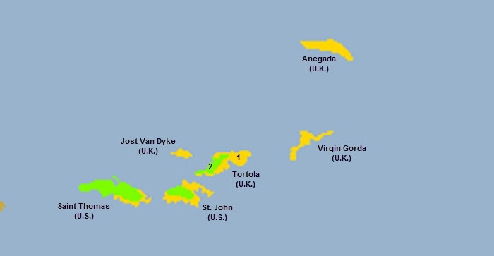
The four main islands are St. Thomas, St. John, Tortola, and Virgin Gorda

Its major environmental issues include limited natural freshwater resources (except for a few seasonal streams and springs on Tortola, most of the islands' water supply comes from wells and rainwater catchments).
The British Virgin Islands are susceptible to hurricanes and tropical storms (July to October).
First inhabited by Arawak and later by Carib Indians, the Virgin Islands were settled by the Dutch in 1648 and then annexed by the English in 1672.
The islands were part of the British colony of the Leeward Islands from 1872-1960; they were granted autonomy in 1967.
The economy, one of the most stable and prosperous in the Caribbean, is highly dependent on tourism generating an estimated 45% of the national income. More than 934,000 tourists, mainly from the United States, visited the islands in 2008. The economy is closely tied to the larger and more populous United States Virgin Islands to the west; the US dollar is the legal currency.

Source: Holger Behr/Wikimedia Commons
Contents
Geography
Location: Caribbean, between the Caribbean Sea and the North Atlantic Ocean, east of Puerto Rico
Geographic Coordinates: 18 30 N, 64 30 W
Area: 151 sq km (Note: comprised of 16 inhabited and more than 20 uninhabited islands; includes the islands of Tortola, Anegada, Virgin Gorda, Jost van Dyke)
Coastline: 80 km
Maritime Claims:
Natural Hazards: hurricanes and tropical storms (July to October)
Terrain: coral islands relatively flat; volcanic islands steep, hilly. The highest point is Mount Sage (521 m).
Land Use:
Climate: subtropical; humid; temperatures moderated by trade winds.
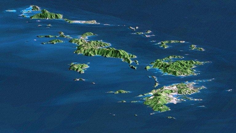
St. Thomas, St. John, Tortola, and Virgin Gorda are the four main islands (front to back) in this east-looking view of the US Virgin Islands and British Virgin Islands. For this view, a nearly cloud-free Landsat image was draped over radar elevation data, and shading was added to enhance the topographic expression. Elevation is shown with 1.5x scaled vertical exaggeration. Coral reefs fringe the islands in many locations and appear as very light shades of blue. Tropical vegetation appears green, while developed areas appear in shades of brown and white. Image credit: NASA, JPL, and NIMA.
Ecology and Biodiversity
Most of the British Virgin Islands are within the Leeward Islands xeric scrub ecoregion [1]. The north western part of Tortola and Jost van Dyke along with nearby islands are within the Leeward Islands moist forests ecoregion [2]
See also:
- Common coral reef fishes of the British Virgin Islands
- Common coral reef fishes of Virgin Gorda
- Biological diversity in the Caribbean Islands
- Protected areas of British Virgin Islands
Government
Dependency Status/Government Type: overseas territory of the UK; internal self-governing
Capital: Road Towm - 9,000 (2009)
Legal System: English common law
People and Society
Population: 31,148 (July 2012 est.)
Ethnic Groups: black 82%, white 6.8%, other 11.2% (includes Indian and mixed) (2008)
Age Structure:
0-14 years: 19.6% (male 2,526/female 2,457)
15-64 years: 74.1% (male 9,631/female 9,174)
65 years and over: 6.3% (male 827/female 768) (2011 est.)
Population Growth Rate: 2.443% (2012 est.)
Birthrate: 10.69 births/1,000 population (2012 est.)
Death Rate: 4.82 deaths/1,000 population (July 2012 est.)
Net Migration Rate: 18.56 migrant(s)/1,000 population (2012 est.)
Life Expectancy at Birth: 77.95 years
male: 76.73 years
female: 79.24 years (2012 est.)
Total Fertility Rate: 1.22 children born/woman (2012 est.)
Languages: English (official)
Urbanization: 41% of total population (2010) growng at an annual rate of change of 1.7% (2010-15 est.)
Economy
The economy, one of the most stable and prosperous in the Caribbean, is highly dependent on tourism generating an estimated 45% of the national income.
More than 934,000 tourists, mainly from the US, visited the islands in 2008.
In the mid-1980s, the government began offering offshore registration to companies wishing to incorporate in the islands, and incorporation fees now generate substantial revenues. Roughly 400,000 companies were on the offshore registry by yearend 2000. The adoption of a comprehensive insurance law in late 1994, which provides a blanket of confidentiality with regulated statutory gateways for investigation of criminal offenses, made the British Virgin Islands even more attractive to international business.
Livestock raising is the most important agricultural activity; poor soils limit the islands' ability to meet domestic food requirements.
Because of traditionally close links with the US Virgin Islands, the British Virgin Islands has used the US dollar as its currency since 1959.
GDP: (Purchasing Power Parity): $853.4 million (2004 est.)
GDP: (Official Exchange Rate): $1.095 billion (2008)
GDP- per capita (PPP): $38,500 (2004 est.)
GDP- composition by sector:
agriculture: 0.9%
industry: 10.3%
services: 88.7% (2011 est.)
Agricultural products: fruits, vegetables; livestock, poultry; fish
Industries: tourism, light industry, construction, rum, concrete block, offshore financial center
Currency: the US dollar is used