Eastern Himalayan alpine shrub and meadows
| Topics: |
This content is not assigned to a topic
|
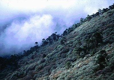
Kanchenjunga Conservation Area, Nepal Photograph by Chris Carpenter
The Eastern Himalayan Alpine Shrub and Meadows ecoregion supports one of the world's richest alpine floral displays that becomes vividly apparent during the spring and summer when the meadows explode into a riot of color from the contrasting blue, purple, yellow, pink, and red flowers of alpine herbs. Rhododendrons characterize the alpine scrub habitat closer to treeline. The tall, bright-yellow flower stalk of the noble rhubarb, Rheum nobile (Polygonaceae), stands above all the low herbs and shrubs like a beacon, visible from across the valleys of the high Himalayan slopes.
The plant richness in this ecoregion sitting at the top of the world is estimated at more than 7,000 species, a number that is three times what is estimated for the other alpine meadows in the Himalayas. In fact, from among the Indo-Pacific ecoregions, only the famous rain forests of Borneo are estimated to have a richer flora. Within the species-rich landscape are hotspots of endemism, created by the varied topography, which results in very localized climatic variations and high rainfall, enhancing the ability of specialized plant communities to evolve. Therefore, the ecoregion boasts the record for a plant growing at the highest elevation in the world: Arenaria bryophylla, a small, dense, tufted cushion-forming plant with small, stalkless flowers, was recorded at an astonishing 6,180 m by A. F. R. Wollaston.
Location and General Description
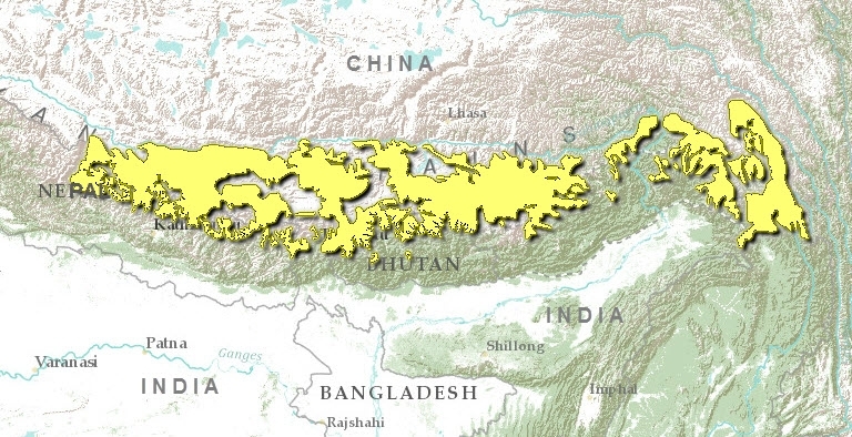
The Eastern Himalayan Alpine Shrub and Meadows represent the alpine scrub and meadow habitat along the Inner Himalayas to the east of the Kali Gandaki River in central Nepal. Within it are the tallest mountains in the world-Everest, Makalu, Dhaulagiri, and Jomalhari-which tower far above the Gangetic Plains. The alpine scrub and meadows in the eastern Himalayas are nested between the treeline at 4,000 meters (m) and the snowline at about 5,500 m and extend from the deep Kali Gandaki gorge through Bhutan and India's northeastern state of Arunachal Pradesh, to northern Myanmar.
In addition to being the world's tallest mountain range, the Himalayas are also one of the youngest. Their origin has been traced back to the collision between the northward-drifting Deccan Plateau and the northern Eurasian continent. During this collision the northern edge of the Deccan Plateau pushed beneath Eurasia and began to raise the northern continent from beneath the Tethys Sea to create what is now the Tibetan Plateau, 4,000 m above sea level. The Himalayan mountains were thrust upward during subsequent geologic uplifts and upheavals to form the highest mountain range in the world .
The eastern Himalayas are wetter than the western extents of the mountain range because of precipitation from the May-September southwest monsoon. The water it brings from the Bay of Bengal is first intercepted and expended here. But within this general trend, the complex topography creates rainshadows, resulting in very localized climatic variations. For instance, Pokhara, in the southern Annapurna Range, faces the brunt of the monsoonal rains and receives more than 3,500 millimeters (mm) of annual rainfall, but Jomsom, just 65 kilometers (km) north and in Pokhara's rainshadow, gets only 300 mm of rainfall. Aspect is another important criterion that determines local climatic variation. The north-facing slopes are less exposed to sunlight and are thus cooler and retain more moisture. Therefore, they are more likely to harbor a specialized Himalayan flora adapted to these moist, microclimatic conditions.
The scrub vegetation of this ecoregion is dominated by colorful Rhododendron species that exhibit high species turnover along the west-east gradient from eastern Nepal to northern Myanmar. For instance, some common species in the Nepal alpine scrublands, Rhododendron campanulatum, R. wallichi, R. campylocarpum, R. thomsonii, and R. wightii drop out of the assemblage in Bhutan, where R. bhutanense, R. aeruginosum, R. succothii, R. fragariiflorum, R. pumilum, R. baileyi, and R. pogonophyllum are added to the assemblage. And further east in northern Myanmar, the characteristic assemblage consisting of R. calciphila, R. crebriflorum, R. chryseum, R. riparium, R. sanguineum, and R. saluenense is entirely different.
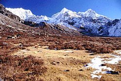 Kanchenjunga Conservation Area, Nepal. (Photograph by Chris Carpenter)
 The herbs that lend springtime color to the alpine meadows include hundreds of species from genera such as Alchemilla, Androsace, Primula, Diapensia, Impatiens, Draba, Anemone, Gentiana, Leontopodium, Meconopsis, Saxifraga, Sedum, Saussurea, Rhododendron, Potentilla, Pedicularis, and Viola. Several of these (e.g., Picrorhiza, Rheum, Aconitum, and Paris) are prized as medicinal herbs. The splendor and richness of these meadow communities in full bloom are difficult to describe.
The upper elevations of the ecoregion transition into rock screes, where shallow soils support grasses, cushion-forming plants, and rhododendron scrub among large boulders and craggy rock faces.
Biodiversity Features
The fauna of this ecoregion is surprisingly rich in large vertebrates. Important mammal species include the snow leopard (Uncia uncia), which roams the high-altitude meadows; blue sheep (Pseudois nayur); Himalayan tahr (Hemitragus jemlahicus); and the formidable takin (Budorcas taxicolor). Avian predators such as the lammergeier (Gypaetus barbatus), Himalayan griffon (Gyps himalayensis), black eagle (Ictinaetus malayensis), and northern goshawk (Accipiter gentilis) soar high among the peaks searching for colonial marmots (Marmota himalayana), which build extensive burrows in which they gain refuge.
The ecoregion harbors about 100 mammal species, but because the small and mid-sized mammals are poorly studied in this inaccessible habitat, this number probably is only a conservative estimate. Only one species is considered near endemic to this ecoregion (table 1). The Vespertilionid bat is also found in the Karakoram-West Tibetan Plateau Alpine Steppe ecoregion, much further west, and probably inhabits several other ecoregions.
|
Table 1. Endemic and Near-Endemic Mammal Species. Family Species Vespertilionidae Eptesicus gobiensis An asterisk signifies that the species' range is limited to this ecoregion. There are several threatened species such as the endangered snow leopard, takin, and Himalayan goral (Naemorhedus baileyi), and the vulnerable serow (Capricornis sumatraensis) and Himalayan tahr (Hemitragus jemlahicus) (in eastern Nepal and Sikkim) in this ecoregion (Eastern Himalayan alpine shrub and meadows) . A recent record of a single takin bull was reported from Sikkim, far from the nearest known takin population in Jigme Dorji National Park in Bhutan. The 115 bird species known in this ecoregion include one near-endemic species (table 2). This partridge is limited to the eastern Himalayas and is also found in the adjacent Himalayan Subtropical Broadleaf Forests, Eastern Himalayan Broadleaf Forests, and Eastern Himalayan Sub-Alpine Conifer Forest.
| ||||||||