Djoudj National Bird Sanctuary, Senegal
| Topics: |
Contents
- 1 Introduction Djouj National Bird Sanctuary is a World Heritage Site in Senegal (Djoudj National Bird Sanctuary, Senegal) located at 16°30'N, 16°10'W. In the Senegal River delta, the Djoudj Sanctuary is a wetland of 16,000 hectares (ha), a large seasonally flooded area of lakes, ponds and bayous surrounded by streams and backwaters, which form a living but fragile sanctuary for three million migrant birds and a large breeding population, including white pelican, purple heron, African spoonbill, great egret and cormorant. There are many threats to site. Since 1999 the Sanctuary has been threatened by the rapid invasion of a water plant, Salvinia molesta, which had also reached Diawling National Park in Mauritania across the river. This is one of the most invasive plants in the world and threatens the ecosystem and economy of the region. Use in 2001 of biological control by plant-eating weevils from South Africa, began to clear the weed but may need annual reapplication. The national authorities agreed to inscription on the List to facilitate a three year task of eradication and help their appeal for financial support from donors.
- 2 Geographical Location
- 3 Date and History of Establishment
- 4 Area
- 5 Land Tenure
- 6 Altitude
- 7 Physical Features
- 8 Climate
- 9 Vegetation
- 10 Fauna
- 11 Cultural Heritage
- 12 Local Human Population
- 13 Visitors and Visitor Facilities
- 14 Scientific Research and Facilities
- 15 Conservation Value
- 16 Conservation Management
- 17 IUCN Management Category
- 18 Further Reading
Introduction Djouj National Bird Sanctuary is a World Heritage Site in Senegal (Djoudj National Bird Sanctuary, Senegal) located at 16°30'N, 16°10'W. In the Senegal River delta, the Djoudj Sanctuary is a wetland of 16,000 hectares (ha), a large seasonally flooded area of lakes, ponds and bayous surrounded by streams and backwaters, which form a living but fragile sanctuary for three million migrant birds and a large breeding population, including white pelican, purple heron, African spoonbill, great egret and cormorant.
There are many threats to site. Since 1999 the Sanctuary has been threatened by the rapid invasion of a water plant, Salvinia molesta, which had also reached Diawling National Park in Mauritania across the river. This is one of the most invasive plants in the world and threatens the ecosystem and economy of the region. Use in 2001 of biological control by plant-eating weevils from South Africa, began to clear the weed but may need annual reapplication. The national authorities agreed to inscription on the List to facilitate a three year task of eradication and help their appeal for financial support from donors.
Geographical Location
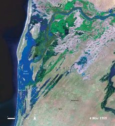 Landsat image of Djoudj National Bird Sanctuary. (Source: National Aeronautics and Space Administration)
 In the extreme northwest of the country on the Mauritanian border, in the delta of the Senegal River about 60 kilometers (km) north-northeast of Saint-Louis. In a wide low valley 10 km north of Ross-Bethio: 16°30'N, 16°10'W.
Date and History of Establishment
- 1962: A nearby area of 3 ha was first classified a nature reserve by Decree No.62-065 in 1962;
- 1971: Designated a national bird sanctuary by Decree No.71-411 (13,000 ha);
- 1975: Enlarged by Decree No.75-1222 to 16,000 ha;
- 1977: Designated a Wetland of International Importance under the Ramsar Convention.
- 2000: Placed on the list of World Heritage in danger because of a destructive invasion by waterweed
Area
16,000 ha; adjoining Diawling National Park, Mauritania (13,000 ha).
Land Tenure
Government, in Region du Fleuve province. Managed by the National Parks Service of the Ministry for the Protection of Nature.
Altitude
From near sea level to about 20 meters (m).
Physical Features
The Sanctuary is a small part of the wide delta floodplain of the Senegal river, the second largest river in west Africa, which marks the line between the Sahara and the Sahel and forms an important ecological barrier on the desert edge. A third of the wetland is in Mauritania. The Sanctuary is in the basin of the brackish Djoudj bayou (distributary or marigot) between the main river channel to the north and the Gorom bayou to the south. It is an area of three related habitats: bayous, meres and backwaters dry for three months every year, usually flooded basins (cuvettes) and irregularly flooded alluvial plains. During the dry season it is the only naturally green spot along the whole river. The ground is covered with impermeable salt-impregnated alluvial clays forming saline flats. It was originally steppe, paddy-fields, marshes (Tidal marsh) and lagoons subject to annual flooding from September. But dikes have canalized the river and an anti-saltwater barrier built downstream now keeps fresh water in the basin for long periods, replacing the former balance of wet and dry, fresh and saltwater cycles.
Climate
This is a semi-arid Sahelian climate with alternate wet and dry seasons, tempered by the ocean and sea winds. The mean annual rainfall, between July and mid-September, never exceeds 300 millimeters (mm), but during the dry months (March to June), it is the most humid area in the region. There is 40% dry season and 70% wet season humidity. Flood levels are highest in October, but in recent years rainfall has been less than a fifth of the average and Djoudj has become much drier. The mean annual temperature is 27°Celsius (C), but during the cold season between December and March the temperature can fall to 10°C.
Vegetation
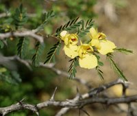 Acacia nilotica. (Source: Texas A&M University)
 The vegetation is a mosaic of Sahelian habitats, the product of low rainfall on halomorphic soils. The savanna is dominated by spiny bushes, acacias such as Acacia nilotica (which needs seasonal flooding) A.tortilis, A.seyal, Balanites aegyptiaca, Tamarix senegalensis and Euphorbia balsamifera. Herbs include Mimosa pigra, Echinochloa colonum and Aeschynomene spp.; grasses include Oryza longistemma, Echinochloa stagnina and Vossia cuspidata. Halophytic plants, particularly Salicornia spp., cover much of the area. During the rains and because a barrier dam has prevented salt water from moving upstream, dense reedmace Typha australis and waterlily Nymphaea spp. now grow in the flood zones and, in the shelter of this, aquatic vegetation became dominated first by Pistia stratoites and since 1999, by Salvinia molesta, a rank freshwater invader, to levels which have become dangerous to other life.
Fauna
For millions of Palaearctic ducks and other aquatic birds, the Sanctuary, along with the Niger swamps in Mali and Lake Chad, is one of the great staging and wintering areas on the far side of the Sahara. From September to April, an estimated three million migrants pass through, joining a dense population of resident breeding birds. Between 450-550,000 Anatidae, 250,000 Limicolae, 20,000 greater flamingos Phoenicopterus ruber, 3,000-12,000 lesser flamingos P. minor and 2,500 European spoonbills Platalea leucorodia, owe their winter survival to the quality of the environment of the Senegal river delta. 300 species have been recorded including garganey Anas querquedula, shoveler A. clypeata, pintail A. acuta, ruff Philomachus pugnax, and black-tailed godwit Limosa limosa. About 5,000 white pelican Pelecanus onocrotalus nest here regularly, as well as pinkbacked pelican Pelecanus rufescens, common cormorant Phalacrocorax carbo, white-breasted cormorant P. lucidus, African darter Anhinga rufa, night heron Nycticorax nycticorax, squacco herons Ardeola spp., green heron Butorides striatus, various egrets Egretta spp., purple heron Ardea purpurea, grey heron Ardea cinerea, yellowbilled stork Mycteria ibis, sacred ibis Threskiornis aethiopicus, glossy ibis Plegardis falcinellus, African spoonbill Platalea alba, white-faced tree duck Dendrocygna viduata, fulvus tree duck D. bicolor, spur-winged goose Plectropterus gambensis, and Sudan bustard Otis arabs.
Other animals include warthog Phacochoerus aethiopicus, jackal Canis aureus, and African manatee Trichechus senegalensis (V). Red-fronted and dorcas gazelles Gazella rubifrons and G.dorcas and the Nile crocodile crocodylus niloticus have been successfully reintroduced. There are also python Python sebae and monitor lizards, Varanus spp.
Cultural Heritage
No information is available.
Local Human Population
The local Wolof and Halpulaar, Haratin and Sarakolé farmers have developed ways of using the local resources subtly adjusted to the very varying regime of flooding and drought: fishing, mixed farming, rice-growing and grazing cattle on the dry season pastures. There are also transhumant herders, Moors from Mauritania and Pleuh from inland who move in as the wet season ends, with whom there is conflict if drought forces them to stay too long in the floodplain.
Visitors and Visitor Facilities
More than 5,000 tourists visited the park each year in the 1990s. One camp is open from mid-November to mid-April and there are hotels in St Louis nearby. A second has been planned on the northeast border. There are a dozen bird observation points on the borders of the most important waterbodies. Canoes can be hired. A small eco-museum has been constructed by the St Louis Club Jeunes-Nature.
Scientific Research and Facilities
Research includes rodent studies, bird ringing to investigate migration routes, and population dynamics. L’Office de la Recherche Scientifique et Technique d’Outremer (ORSTOM) has sponsored research in this area since 1955. Studies of waders were carried out in 1983-1984 by the Station Biologique de la Tour du Valat, France. An expedition to catch and ring palaearctic migrants was undertaken in 1990, for which some 3,300 birds of over 70 species were ringed. There is an observation hut on site. A biological research station was established in St. Louis in 1990 for the area’s parks.
Conservation Value
The park was mainly established as an important area for the protection, study and viewing of birds. It supports three million waterfowl and as one of the first fresh water sources they reach after crossing 200 km of the Sahara, is one of the main West African sanctuaries for Palaearctic migrants.
Conservation Management
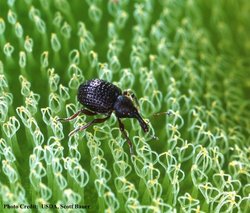 Plant-eating Cyrtobagous salviniae weevil. (Source: United States Geological Survey)
 In 1991 IUCN and WWF financed a plan for the Sanctuary to cover the management of water, habitats for important species, relations with local people, tourism and education in conserving the area. Water supply in the region is a problem, and permanent dams have been built to regulate the flow of the Senegal River, including a dam in Mali. With the completion of the Diama anti-salinity barrage downriver, the water supply for Djoudj is now much more secure than at any time in the past except in a small undiked area. A dike was built around the park and a system of dams has been maintained to counter the effects of the Diama barrage, also of the large hydroelectricity and irrigation Manantali dam upstream in Mali so that water levels would not be affected by alterations in the flow of the river, or by intensive upstream cultivation which could increase levels of herbicide and pesticide residues in the water. Effective management depends on the continued reinforcement of dykes, repair of water-control structures and dredging of silted canals. Until 1987 rigid protection was enforced. Since then there has been a policy of cooperating with local villagers whose numbers are growing, allowing them to use the varied resources of the site in the way they know best . The park is closed three months of the year for park management. Wardens are stationed in five watch posts, one in the centre and four on the boundaries. Administration zones are co-ordinated by a ranger.
Management Constraints
Rainfall has been too low in the past few years for water levels to be normal. The Compagnie Sucrière Sénégalaise built a temporary dam just upstream at Kheune to prevent salt water flowing up the Senegal River in the dry season which reduced the supply of fresh water to Djoudj but the 1984 flood swept it away and Djoudj was replenished normally. In the 1984/1985 dry season, Djoudj was connected by canal with fresh water above the Kheune barrage to stop it drying out. However, because of corrosion of one of the two sluice gates into the park, staff were unable to control water levels which were largely determined by the Diama reservoir levels. Pelican nesting sites were threatened, so substitute islets were successfully built for the birds' use. Djoudj was placed on the World Heritage in Danger list between 1984 and 1988 because of the alteration in water levels by these dams. However, habitats at Djoudj are adapted to this threat. But secondary threats to the Sanctuary remain: tree-felling, overgrazing and poaching, which have all been heavy in the past.
The construction of the Diama dam for irrigation and drinking water had the effect of drying out the downstream floodplain, estuary and mangroves and created ideal conditions upstream for invasive freshwater weeds: reed mace Typha australis, which still forms very dense barriers, water lettuce Pistia stratiodes, since reduced, and the major current danger, a south Brazilian water weed Salvinia molesta which originated from imported chickenfeed. This can double its area every four days, and becomes a floating mat which chokes all other life, making fishing and river transport almost impossible. It forms a substrate for other invasive weeds, exhausts the river's oxygen and increases the habitat for disease-bearing snails and mosquitoes. It became such a threat to the riverine ecology and the local economy that the site was again listed in danger in 2000. Very costly measures were taken to eradicate it, first mechanical, and then, successfully, by the concentrated use of biological control by the weevil Cyrtobagus salviniae. The WHB, IUCN, Ramsar Secretariat and FAO all collaborated with the State in the program of eradication which could become a model for Africa.
Staff
A total of 21 rangers and one conservator.
Budget
3 million francs CFA*. In 2000, the WHB conditionally approved US$ 130,475 to finance Phase I of the Salvinia eradication campaign; and in 2001, US$21,690 for a regional workshop in methods of inventorying wetlands.
- franc du Communauté Financiere Africaine
IUCN Management Category
- II National Park. Ramsar site.
- Natural World Heritage Site, inscribed in 1981. Natural Criteria iii, iv
- Listed in Danger in 1984-8 and in 2000 because of the effect of dams and invasion by rampant waterweeds.
Further Reading
- Anon. (n.d.). Unpublished Country and National Parks. Report received 1988. 32 pp.
- Beecroft, R.(1991). Ringing in Senegal; an expedition update. The British Trust for Ornithology (Mar/April) 173: 5.
- Bientema, A. (1990) Management of the Djoudj National Park. In Marchand, M. & Udo de Haes, H. Proceedings of the International Conference on Wetlands. The People's Role in Wetland Management. Centre for Environmental Studies, Leiden, The Netherlands. ISBN: 905191038X.
- CNPPA Summary Status Report (1984). Threatened Protected Areas of the World. (draft).
- Dupuy, A. (1971). Les oiseaux et les mammifères de la cuvette du Djoudj (delta du fleuve Sénégal).Bull. IFAN 33,A (1): 237-248.
- Dupuy, A. (1971). Contribution à l'étude de l'avifaune du delta du Sénégal. Bull.IFAN 33, A(3):737-753
- Dupuy, A.R. (1971). Mission au nouveau parc national des oiseaux du Djoudj. Notes Africaines 132.
- Dupuy, A.R. (1972). Le parc national des oiseaux du Djoudj. Bull.IFAN 34, A(3): 775-781.
- Dupuy, A.R. and Suiro, P. (n.d.) Les Oiseaux du Djoudj. IUCN/WWF. 88 pp.
- Larivière, J. and Dupuy, A.R. (1978). Sénégal: Ses Parcs, Ses Animaux. Editions F.Nathan, Paris.
- Pieterse, A. (2000). Aquatic weed management. In van Rijn, P. (ed.) Weed Management in the Humid and Semi-humid Tropics. Royal Tropical Institute, Amsterdam, The Netherlands. pp. 169-176.
- Roux, F., Jarry, G., Maheao & Tamisier, R. (1976). Importance, structure et origine des populations d'Anatides hivernant dans le delta du Sénégal. L'Oiseau R.F.O. 46: 299-336 and 47: 1-24.
- Secretariat d'Etat Charge de la Nature. (1974). Le Parc National des Oiseaux du Djoudj, Dakar.
- Thorsell, J. (1985). World Heritage Report - 1984. Parks 10(1): 8-9.
- Triplet, P.,Tiega, A. & Pritchard, D. (2000). Mission Report. Djoudj National Bird Sanctuary, Senegal, Sept. 2000, for UNESCO World Heritage Bureau, Paris.
- UNESCO World Heritage Committee (2001) Report on the 24th Session of the World Heritage Committee.
- UNESCO World Heritage Committee (2002) Report on the 25h Session of the World Heritage Committee.
- Van den Top, G.(1990). Senegal delta and lower valley. In Fiselier, J. Living Off the Floods. Edwin, Leiden.
- Voisin, C. (1983). Les ardeides du delta du fleuve Senegal. L'Oiseau et Revue Francaise d'Ornithologie. 53(4).
| Disclaimer: This article is taken wholly from, or contains information that was originally published by, the United Nations Environment Programme-World Conservation Monitoring Centre (UNEP-WCMC). Topic editors and authors for the Encyclopedia of Earth may have edited its content or added new information. The use of information from the United Nations Environment Programme-World Conservation Monitoring Centre (UNEP-WCMC) should not be construed as support for or endorsement by that organization for any new information added by EoE personnel, or for any editing of the original content. |
1 Comment
Peter Howard wrote: 02-02-2011 20:18:24
Readers may want to visit the African Natural Heritage website to view a selection of images and map of the Djoudj National Bird Sanctuary world heritage site, and follow links to Google Earth and other relevant web resources: http://www.africannaturalheritage.org/Djoudj-Bird-Sanctuary-Senegal.html