Deception Island
| Topics: |
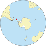
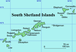
Deception Island isone of the South Shetland Islands of Antarctica,lyingabout 60 miles (150 km) north of the Antarctic Peninsula across the Bransfield Strait.
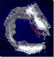
The island is ring-shaped (roughly circular with with a flooded interior), from 7-10 miles across. The island is an active volcano with a drowned breached crater which provides a sheltered harbor, named Port Foster (an oval 5x3 miles, 8x5 km). This harbor was popular in the early nineteenth century with seal hunters. It was known as Williams Harbor among British sealers and Yankee Harbor among American sealers (not to be confused with today's Yankee Harbor on nearby Greenwich Island). The narrow entrance to the harbor (feet, meter wide) is known as Neptune's Bellows.
 Deception Island. (Source)
 The island covers 38 miles² (98.5 km²), of which just over half is glaciated. The highest point on the island is Mount Pond at 1,890 feet (550 meters) high. It is also known as Monte Cambell and Monte Estanque [1].
Eruptions have occurred frequently in the past; most recently in 1970. Volcanic vents (Maars) exist at various places on the island [2].
The climate is polar maritime" with temperatures ranging from +11°C to -28°C. However, because of volcanic activity and numerous vents, the island exhibits several "microclimates" where far higher temperatures have been measured.
The island's plant life is rich in comparison to most of Antarctica, with 18 species of moss or lichens not found elsewhere on the continent.
The first known sighting of the island occurred in January, 1820 by a British expedition led by Edward Bransfield and piloted by William Smith.
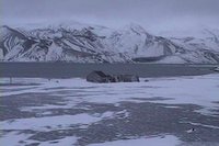
It is thought that American seal hunterNathaniel Palmer was the first to discover the harbor in late 1820as a haven for sealhunters. Later it was also used by whaling ships and as the site for a whaling station. Whaler's Cove, just inside the harbor entrance is the site of an abandoned whaling station[3].
The ice near to the whaling station was used as a landing strip by Hubert Wilkins for the first flights over antarctica in 1928.
While the Island has been claimed by the United Kingdom, Chile and Argentina, it comes under the jurisdiction of the Antarctic Treaty System (1959). Sovereignty is neither recognized nor disputed by the signatories. The Antarctic Treaty System limits military activity and promotes environmental protection and scientific and other peaceful activities. Alternative names include Yaraslav Island (Russia - It was named by the Bellinghausen expedition in 1821), Teil Island, and Isla Decepción.
Permanent research stations on the islands established by the British in the 1940s and 1960s were abandoned because of the volcanic eruptions. Today, summer research stations are maintained by Spain (Gabriel De Castilla[4]) and Argentina (Decepción station), both at at Fumerole Bay {ref|4}}.
Because of the high risks associated with volcanic eruptions, there is no permanent human presence on the island, but the hot springs make it an increasingly popular tourist stop during the austral summer.
References
Further Reading
- Deception Island
- Antarctica: Exploring the Extreme: 400 Years of Adventure,Marilyn J. Landis, Chicago Review Press, 2001
- Below the Convergence: Voyages Towards Antarctica, 1699-1839, Alan Gurney, W.W. Norton and Company, 1997
- The Discovery of the South Shetland Islands, 1819-1820: The Journal of Midshipman C. W. Poynter, R. J. Campbell (editor), Hakluyt Society, 2001
- Antarctica Observed, A.G.E. Jones, Caedmon of Whitby, 1982
- Visualizer
- USGS Geographic Name Information Service
Citation
Saundry, P. (2009). Deception Island. Retrieved from http://editors.eol.org/eoearth/wiki/Deception_Island- ↑ Deception Island, Teresa K. Chereskin, Scripps Istitute of Oceanography] accessed December 4, 2008


