Cocos Island moist forests
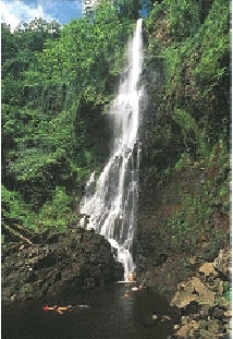
Cocos Island, Costa Rica Photograph by Avi Klapfer
Cocos Island is the only island in the eastern Pacific with very moist tropical flora and fauna, and the only Pacific oceanic island off Central America. In addition to the very moist tropical forest, this small island has a tropical cloud forest, the highest parts of which are undisturbed, and represent the only ecosystem of this type on an eastern Pacific island. The various [[ecosystem]s] and microclimates provide numerous niches with relatively high levels of insular endemism (nearly 30% of plant species and nearly 20% of insect species). The small islands and rocks around Cocos Island and within this ecoregion also maintain important nesting colonies of migratory seabirds such as the brown booby (Sula leucogaster), red-footed booby (Sula sula), Fregata minor, Gygis alba and Anous stolidus. The high biological wealth and endemism present in the coastal and oceanic ecosystems of the island should also be noted. The island’s conservation status is good, although introduced species threaten the balance of natural processes.
Location and General Description
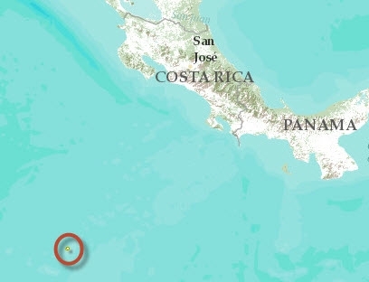 Cocos Island in the central eastern Pacific Ocean (5º32’N-86º59’W) lies 523 kilometers (km) southwest of Cabo Blanco, in Costa Rica; the country to which it has belonged since 1869, and 665 km northeast of the Galapagos Islands, in Ecuador. This small island measures 7.6 km long and 4.4 km across with a surface area of approximately 24,000 hectares (ha). There are also small islets nearby such as Dos Amigos, Rafael and Juan Bautista.
The climate is strongly influenced by the equatorial counter-current, flowing in an easterly direction. It is warm, with an average annual temperature of 23.6 ºC, and extremely wet, with average annual rainfall higher than 6,000 millimeters. It rains throughout the year, although slightly less during the months of January, February and March and to a lesser extent in late September and October. The island represents the only submarine volcano that has emerged from the mountain range of the Cocos tectonic plate, which extends in a southwesterly direction from Costa Rica nearly to the Galapagos archipelago. It is primarily composed of strata of solid lava (basalts) in a well-defined columnar structure. The island probably formed from a hot spot some two million years ago, during the late Pliocene. The topography is irregular, with maximum elevations of 634 meters (m) in Cerro Iglesias and abundant waterways, cliffs, cataracts and caves. The largest rivers are the Genio and the Pittier, that empty into Wafer Bay. The soils can be classified as entisols that are highly acidic, fragile and easily eroded, particularly by high rainfall levels.
The island has dense vegetative cover classified as moist tropical forest; there are 235 known species of plants and 70 of these, or nearly 30%, are endemic. Predominant endemic tree species include the huriki Sacoglottis holdridgei, Ocotea insularis and Cecropia pittieri. There are three principal plant formations. The first is in the coastal zone (up to an elevation of 50 m.), with species such as Erythrina fusca, Cocos nucifera, Annona glabra and various ferns. In the undergrowth, shrubs in the Rubiaceae and Solanaceae families are common and the herbaceous vegetation includes Cyperaceae, Poaceae, Leguminosae and Malvaceae. The second formation is in the mountainous area, starting at an elevation of 50 m continuing to 500 m. The most common canopy species in this formation include "palo de hierro" (Sacoglottis holdridgei), avocado (Ocotea ira) and the endemic Cecropia pittieri. The undergrowth is characterized by the presence of sedges such as Hypolitrum amplum, and various species of arborescent ferns including Alophila armata. There are numerous epiphytic plants such as orchids, ferns, bromeliads and mosses growing throughout the forest strata. A palm that is abundant and endemic on the island is Rooseveltia frankliniana. At the highest elevations starting at 500 m, we find the third type of plant formation, the tropical cloud forest, where Melastoma spp. are frequently found.
Biodiversity Features
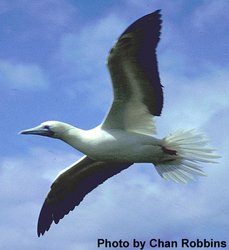 Red-footed booby. (Photograph by Chandler S. Robbins/ USGS)
 The high percentage of endemic plants (nearly 30%), linked to their relatively low biodiversity (235 species), is due to phenomena associated with oceanic islands. The biodiversity of oceanic islands is generally poor with combined characteristics that are known as "disharmonious biota", usually simplified yet exceptional. In addition to the 235 plant species, 85 species of fungi, 74 species of ferns and other cryptogams (pteridophytes, psilophytes and lycopodiophytes) and 128 species of mosses and hepaticas (briophytes) have been identified, this latter group has exceptional diversity. Some plant species have evolved adaptations that allow them to survive in a habitat devoid of a full faunal complement as that found in the mainland. An example is Mucuna urens, which has flowers that are clearly different from the continental plant because the island form is pollinated by an endemic finch rather than a bat, which do not exist on the island.
The diversity of fauna is also low but at the same time there is a high percentage of endemism. There are 362 known species of insects, 65 of which are endemic to the island (18% of the total), although it is estimated that the total number of insects on the island could be as high as 800 species. The most diverse groups are the Lepidoptera and Formicidae. There are also spiders, centipedes, millipedes, isopods and miriapods. The endemic spider, Wendilgarda galapagensis is worth noting as it represents an example of niche expansion in an invertebrate, showing greater variation on the island in terms of its habitat selection and web design and construction than continental species of the same genus. There is a total absence of amphibians on the island, as happens in other oceanic islands far from continental masses. The two existing species of land reptiles, the anolis lizard (Norops townsendii) and the gecko (Sphaerodactylus pacificus), are endemic. Of the seven species of land birds, the Cocos cuckoo (Coccyzus ferrugineus), the Cocos flycatcher (Nesotriccus ridgwayi) and the Cocos finch (Pinaroloxias inornata) are also endemic. This latter species belongs to a subfamily of finches that lives only on Cocos and the Galapagos Islands showing foraging specialization on the islands that may contribute to the high level of intra-species variation. Cocos Island is considered one of the 27 areas of avian endemism in Central America and the Caribbean because it has three species with limited range that are confined to this ecoregion alone. The five land mammals present on the island are introduced.
Current Status
The entire island was declared a National Park and Biological Reserve by the government of Costa Rica in 1978, a World Heritage Site by UNESCO in 1997 and a Wetland of International Importance. Most of the island natural habitat can be considered intact, despite the negative influence of introduced plants and animals. The low relative biodiversity and isolation of this ecoregion make it particularly vulnerable to disturbances.
Types and Severity of Threats
After two failed attempts to settle the island, the island has remained free of permanent human intervention. The first settlers introduced different agricultural plant species as well as domestic animals and these continue to represent serious threats to the maintenance of the natural [[ecosystem]s]. The crops introduced on the island include guava groves, coffee plantations and cocoa plantations. Their spread has adverse effects on the natural equilibrium of the park’s ecosystems. Most of these effects are caused by coffee plants (Coffea arabica) that have invaded certain areas of the undergrowth, particularly around Wafer Bay. Of the mammal species introduced, wild boars (Sus scrofa) have the worst impact because, more than other animals, boar alter plants in the undergrowth, affect the spread of many plants and destroy their root systems, accelerating soil erosion. In the long run, the affect could be as far reaching as damaging the coral reefs through siltation.
Justification of Ecoregion Delineation
This ecoregion was identified as unique and distinct from the mainland by the presence of numerous endemic species, including three endemic bird species and by its great distance and subsequent isolation from the mainland.
Additional information on this ecoregion
- For a shorter summary of this entry, see the WWF WildWorld profile of this ecoregion.
- To see the species that live in this ecoregion, including images and threat levels, see the WWF Wildfinder description of this ecoregion.
- World Wildlife Fund Homepage
Further Reading
- Alpízar, H., y L. Robles. Arquitectura para la conservación de la Isla del Coco. San José, Costa Rica: Tesis de grado, Universidad de Costa Rica.
- Caribbean Environmental Programme (CEP) 1996. Status of Protected Area Systems in the Wider Caribbean Region. CEP Technical Report No. 36
- Cortés, F. 1986. Coco Island: Management and development plan. San José, Costa Rica: Service of National Parks.
- Eberhard, G.W. 1989. Niche expansion in the spider Wendilgarda galapagensis (Araneae, Theridiosomatidae) on Cocos Island. Revista de Biología Tropical 37:163-168.
- Government of Costa Rica. 1996. Coco’s Island marine and terrestrial conservation area: Nomination for inclusion in the World Heritage List of natural properties. San José, Costa Rica: Government of Costa Rica.
- Harcourt, C., and J. Sayer, editors. 1996. The Conservation Atlas of Tropical Forests: The Americas. New York City: Simon & Schuster. ISBN: 0133408868
- IUCN. 1982. IUCN Directory of Neotropical Protected Areas. Dublin: Tycooly International Publishing Limited.
- Mercadeo y Tecnología, y J. Cortés. 1998. Vida en el bosque tropical del Neotrópico. Documental sobre la vegetación de la Isla.
- Montoya, M. 2001. La biota en una isla oceánica como Isla del Coco. Ambientico 88.
- Plaza, R. 1998. Determinación de la capacidad de carga turística terrestre en el Parque Nacional Isla del Coco, Cosa Rica. San José, Costa Rica: Tesis de grado, Universidad de Costa Rica.
- Strattersfield, A.J., M.J. Crosby, A.J. Long and D.C. Wege. 1998. Endemic Bird Areas of the World: Priorities for Biodiversity Conservation. BirdLife International, Cambridge, UK. ISBN: 1560985747
- Tosi Jr., J.A. 1969. Republica de Costa Rica: mapa ecológico. Map 1:750,000. Tropical Science Center, San Jose, Costa Rica.
- Tournon, J. and G.E. Alvarado. 1997. Carte géologique de Costa Rica: notice explicative. Échelle: 1:500.000. San José, Costa Rica: Editorial Tecnológica de Costa Rica.
- UNEP-WCMC, 1997. World Heritage Site: Isla del Coco Marine and Terrestrial Conservation Area, Costa Rica.
- Wege, D. C., and A. J. Long. 1995. Key Areas for Threatened Birds in the Neotropics. Washington, D.C., USA: Birdlife International, Smithsonian. ISBN: 0946888310
| Disclaimer: This article is taken wholly from, or contains information that was originally published by, the World Wildlife Fund. Topic editors and authors for the Encyclopedia of Earth may have edited its content or added new information. The use of information from the World Wildlife Fund should not be construed as support for or endorsement by that organization for any new information added by EoE personnel, or for any editing of the original content. |