Central China loess plateau mixed forests
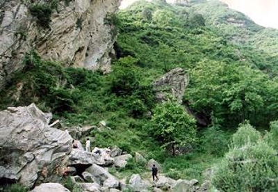
West of the Yellow River Basin and the North China Plain lies a plateau of wind-blown dust and glacial till up to 200 meters (m) thick. High winds and lack of vegetation contribute to the dust storms for which northern China is infamous, and account for the distinctive color of the Yellow River and the Yellow Sea. Vegetation on the central China loess plateau consists of mixed deciduous broadleaf forests in the northern and eastern areas closer to the sea. Because the loess plateau is well-suited to agriculture, natural forests in most areas were largely replaced centuries ago by agricultural cropland and pasture. In spite of the region’s almost complete transformation, small population of rhesus macaque (Macaca mulatta), musk deer (Moschus berezovskii), giant salamander (Megalobatrachus davidiana), and Koklass pheasant (Pucrasia macrolopha) still persist.
Location and General Description
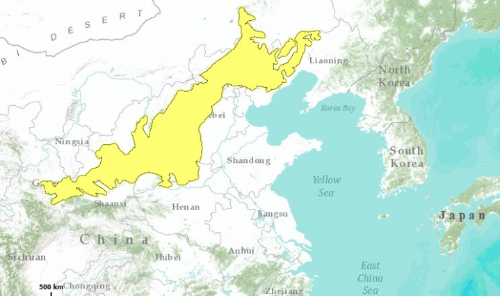
The Central China Loess Plateau lies to the northwest of the Yellow River Basin (also known as the North China Plain) and forms a transition zone to the steppes and desert regions of Inner (southeastern) Mongolia. The loess plateau extends northeast to southwest for more than 1,000 kilometers (km) and is several hundred kilometers wide. In general, the depth of loess blanketing the landscape increases from the northeast where it merely fills the basins between rocky hills to the southwest where it constitutes the hills themselves. This gradient means that the ecoregion includes rocky mountainous habitats as well as unconsolidated loess material. Because loess soils are high in nitrogen, potassium and phosphorus, and because they retain water effectively, they are productive despite the region’s seasonally dry climate.
Vegetation on the central China loess plateau consists of mixed deciduous broadleaf forests in the northern and eastern parts that face the sea. This changes gradually northwestward to low steppe vegetation in the portion that lies adjacent to Inner Mongolia. Because the loess plateau is well-suited to agriculture, natural forests in most areas were largely replaced centuries ago by agricultural cropland and pasture. With the loss of forest cover, erosion has increased so that today erosion has affected 45 percent of the area, with an average annual soil loss of 3,720 tons per km2. During recent decades, trees and other kinds of vegetation have been planted in an effort to reduce the amount of erosion, but these plantations have not been intended to restore the natural forest.
Original vegetation in the northern part of the loess plateau consisted of temperate, deciduous broadleaf forests dominated by oak (Quercus spp.) with associated species consisting of birch (Betula spp.), maple (Acer spp.) and linden (Tilia spp.) at the higher elevations. The elms (Ulmus spp. and Celtis spp.), ash (Fraxinus spp.), Hovenia spp., and Pistacia spp. are dominant tree species at the lower elevations adjacent to the North China Plain. Higher elevations support forests with a strong boreal character comprised of birch, aspen (Populus tremula) and and willow (Salix spp.). Other boreal taxa such as spruce (Picea spp.) and mountain ash (Sorbus spp.) are also recorded in these high-elevation areas.
Today, secondary growth, a result of disturbances such as logging, cultivation, and grazing, is more widespread than the original forests described above. Disturbed areas support shrub vegetation such as hazel (Corylus spp.), Vitex negundo, Ostryopsis davidiana, and Spiraea pubescens. Where grazing is intense, thorny shrubs predominate. These include taxa such as Zizyphus sativa and Caragana spp. that are well-adapted to the seasonally dry conditions that occur here. Caragana is a plant that is also very important on the cool, semi-arid steppes of the Qinghai-Tibet Plateau.
Biodiversity Features
Although the original forest vegetation throughout this ecoregion is rather degraded, several nature reserves protect remnants of the climax forest. Not all of the reserves protect areas covered with loess, however. Much of the protected landscape consists of rocky hills, less suited for farming, that emerge from the loess plateau. The Lu Liang Mountains of central Shanxi Province contain the Pangquan Gou Nature Reserve (105 km2), a major breeding ground for the brown-eared pheasant (Crossoptilon mantchuricum). They also serve as a type location for north China larch (Larix principis-repprechtii). Three other protected bird species have been recorded from this area: black stork (Ciconia nigra), Mandarin duck (Aix galericulata) and golden eagle (Aquila chrysaetos). Another nature reserve, Luya Shan (215 km2), in the northeastern corner of the Luliang Mountains, provides additional habitat for brown-eared pheasant. Here conifer forests comprised of Picea spp. and Larix spp. grow with a relatively high cover of 31 percent.
At the southernmost edge of this ecoregion, near the Huang He (Yellow River) in southern Shanxi Province is Li Shan Nature Reserve (248 km2). Li Shan supports warm temperate forest that is reported to provide habitat for several rare vertebrates including Chinese [[population]s] of rhesus macaque (Macaca mulatta), musk deer (Moschus berezovskii), giant salamander (Megalobatrachus davidiana), and Koklass pheasant (Pucrasia macrolopha).
Current Status
Forests have been cleared throughout this ecoregion over the past few thousand years. The mid-twentieth century was a time of especially severe deforestation. This gradual conversion to agriculture has probably contributed to recent erosion. Afforestation efforts (mainly since the 1960’s) have been extensive, but are not directed toward restoration of original habitat. Plantation forests contain only a few tree species, many of which were not originally components of the forest in this region. Today, intact forest cover in Shanxi Province, where the loess plateau is well-developed, is estimated at only 5 percent, with more extensive areas of degraded forest. Luya Shan Nature Reserve is reportedly difficult to manage due to villagers living in the core area.
Types and Severity of Threats
As the government plans to intensify agricultural production in this area in the future, conservation goals for this ecoregion should include efforts to identify and conserve remaining patches of natural forest growing on loess soils. These landscapes could also serve as a model for afforestation using native species. Later, wildlife reintroduction programs might become feasible. Restoration of habitat in this ecoregion will also require conservation education and improved management of the nature reserves, preferably in a manner that is sensitive to the needs of the local people.
Justification of Ecoregion Delineation
The boundary is formed by the CVMCC Vegetation Map of China deciduous classes and temperate deciduous shrubs classes. Coniferous forests at higher altitudes are also included. The area is comparable to the Loess Plateau biogeographic subunit in the Oriental Deciduous Forests according to Mackinnon.
Additional Information on this Ecoregion
- For a shorter summary of this entry, see the WWF WildWorld profile of this ecoregion.
- To see the species that live in this ecoregion, including images and threat levels, see the WWF Wildfinder description of this ecoregion.
- World Wildlife Fund Homepage
Further Reading
- Chinese Vegetation Map Compilation Committee. 1979. Vegetation map of China. Map (1:10,000,000). Science Press, Beijing, China. ISBN: 7030089561.
- Laidler, L. and K. Laidler. 1996. China’s Threatened Wildlife. Blandford, London. ISBN: 0713723726.
- Liu Guobin. 1999. Soil conservation and sustainable agriculture on the Loess Plateau: challenges and prospects. Ambio 26(8).
- MacKinnon, J. 1996. Wild China. The MIT Press, Cambridge MA.ISBN: 0262133296.
- Mackinnon, J., M. Sha, C. Cheung, G. Carey, Z. Xiang, and D. Melville. 1996. A biodiversity review of China. World Wide Fund for Nature, Hong Kong.
- Zhao, J. editor. Zheng Guangmei, Wang Huadong, Xu Jialin. 1990. The Natural History of China. McGraw Hill Publishing Company, New York. ISBN: 0002190435.
| Disclaimer: This article is taken wholly from, or contains information that was originally published by, the World Wildlife Fund. Topic editors and authors for the Encyclopedia of Earth may have edited its content or added new information. The use of information from the World Wildlife Fund should not be construed as support for or endorsement by that organization for any new information added by EoE personnel, or for any editing of the original content. |

