Air masses (Pollution)
Contents
Air masses
Introduction Global airmasses. (Source: NOAA (Air masses) )
An air mass is a large body of air with generally uniform temperature and humidity. The area from which an air mass originates is called a "source region."
Air mass source regions range from extensive snow covered polar areas to deserts to tropical oceans. The United States is not a favorable source region because of the relatively frequent passage of weather disturbances that disrupt any opportunity for an air mass to stagnate and take on the properties of the underlying region. The longer the air mass stays over its source region, the more likely it will acquire the properties of the surface below.
The four principal air mass classifications that influence the continental United States according to their source region are:
- Polar latitudes - Located poleward of 60° north and south.
- Continental - Located over large land masses between 25°N/S and 60°N/S.
- Maritime - Located over the oceans between 25°N/S and 60°N/S
- Tropical latitudes - Located within about 25° of the equator.
As these air masses move around the earth they can begin to acquire additional attributes. For example, in winter an arctic air mass (very cold and dry air) can move over the ocean, picking up some warmth and moisture from the warmer ocean and becoming a maritime polar air mass (mP) - one that is still fairly cold but contains moisture. If that same polar air mass moves south from Canada into the southern U.S. it will pick up some of the warmth of the ground, but due to lack of moisture it remains very dry. This is called a continental polar air mass (cP).
The Gulf Coast states and the eastern third of the country commonly experience the tropical air mass in the summer. Continental tropical (cT) air is dry air pumped north, off of the Mexican Plateau. If it becomes stagnant over the Midwest, a drought may result. Maritime tropical (mT) air is air from the tropics which has moved north over cooler water.
Air masses can control the weather for a relatively long time period: from a period of days, to months. Most weather occurs along the periphery of these air masses at boundaries called fronts.
Fronts

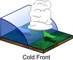
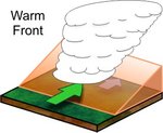
Fronts are the boundaries between two air masses. Fronts are classified as to which type of air mass (cold or warm) is replacing the other. For example, a cold front demarcates the leading edge of a cold air mass displacing a warmer air mass. A warm front is the leading edge of a warmer air mass replacing a colder air mass. If the front is essentially not moving (i.e. the air masses are not moving) it is called a stationary front.
Fronts don't just exist at the surface of the earth, they have a vertical structure or slope as well. Warm fronts typically have a gentle slope so the air rising along the frontal surface is gradual. This usually favors the development of widespread layered or stratiform cloudiness and precipitation along and to the north of the front. The slope of cold fronts are more steep and air is forced upward more abruptly. This usually leads to a narrow band of showers and thunderstorms along or just ahead of the front, especially if the rising air is unstable.

Cold fronts typically move faster than warm fronts, so in time they "catch up" to warm fronts. As the two fronts merge, an occluded front forms. In the occluded front, the cold air undercuts the cooler air mass associated with the warm front, further lifting the already rising warm air.
Fronts are usually detectable at the surface in a number of ways. Winds usually "converge" or come together at the fronts. Also, temperature differences can be quite noticeable from one side of the front to another. Finally, the pressure on either side of a front can vary significantly.

Here is an example of a location that experiences typical warm frontal passage followed by a cold frontal passage: Clouds (Clouds) lower and thicken as the warm front approaches with several hours of light to moderate rain. Temperatures are in the 50s with winds from the east.
As the warm front passes, the rain ends, skies become partly cloudy and temperatures warm into the mid 70s. Winds become gusty from the south. A few hours later, a line of thunderstorms sweeps across the area just ahead of the cold front. After the rain ends and the front passes, winds shift to the northwest and temperatures fall into the 40s and skies clear.
Reference
- National Weather Service— Air Masses.