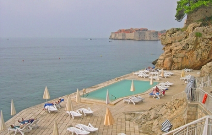
Adriatic Sea
Seas of the World  The Adriatic Sea is a branch of the Mediterranean Sea lying between 2 (50,590 miles2). The Adriatic has a maximum depth of 1233 metres (m) and an average depth of 252 m; although north of a line from Zadar, Croatia to Pescara, Italy, it is less than 100 m deep. The northern end of the sea is the Gulf of Venice and its southern limit is the Strait of Ontranto.
By European standards, the Adriatic is both warm (surface water temperature ranges from 8-13oC in winter to 22-25oC in summer) and low in turbidity; correspondingly, this sea is a popular tourist destination.
 True-color Moderate Resolution Imaging Spectroradiometer (MODIS) image from May 18, 2002. Source: NASA |
Contents
Geography
The Adriatic coastline is heavily indented and includes many islands. As a result the coastline is estimated to be 3737 km (2322 miles) long or 7912 km (4916 miles) when the island coasts are added.
Countries bordering the Adriatic are Italy to the west and north (1249 km), and Slovenia (45 km), Croatia (1775 km, although its straight line "coastal front" is just 526 km), Bosnia and Herzegovena (21 km), Montenegro (249 km) and Albania (396 km).
Important cities along the Adriatic include:
- Italian cities (from south to north) of: Brindisi, Bari, Pescara, Anconda, Ravenna, Venice, and Trieste;
- Croatian cities (from north to south) of Rijeka, Split, and Dubrovnik;
- The Albanian city of Durres
Nearby the Gulf of Venice, on the Po River, and 22 km inland, is the city of Adria which gave its name to the sea before siltation at the mouth of the river seperated it from the coast.

Bathrymetry
The Adriatic is a rectangular basin oriented in a NW-SE direction with a length of about 800 km and a width of about 200 km.
It can be divided into three sub-basins:
1. A northernmost shallow basin with the bottom sloping gently to the south and reaching at most 100 m. This basin extends to approximately a line from Zadar, Croatia to Pescara, Italy.
2. Three pits located along the transversal line off Pescara (one of which is known as the Jabuka Pit), with a maximum depth of 280 m. This basin extends south to the 170 m deep Palagruza Sill.
3. A southern basin called the South Adriatic Pit characterized by approximately circular isobaths, with a maximum depth of about 1200 m in the center.
The bottom rises toward the Strait of Otranto past the southern basin, with the strait having a maximum depth of 780 m, and average depth of 325 m, and a width of about 75 km.
Hydrology
There is an important mass of deep cold water in the Adriatic known as the Adriatic Bottom Water.
The meteorological forcing has been summarized by Artegiani etal. (1993) as:
Mainly during the winter, the Adriatic Sea region is under a continuous influence of passing mid-latitude meteorological perturbations and of the wind systems associated with them. The two main wind systems are the bora and the scirocco. The bora is a dry and cold wind blowing in an offshore direction from the eastern coast. The scirocco blows from the southeast (i.e. along the longitudinal axis of the basin) bringing rather humid and relatively warm air into the region. In particular, the bora produces appreciable buoyancy fluxes through evaporative and sensible heat loss, induces both wind-driven and thermohaline circulation, and, most importantly, is responsible for deep water formation processes.
This is one of the two regions within the Mediterranean where freshwater input exceeds evaporation (the other being the Black Sea). This is due mostly to outflow from the Po River in the north, which accounts for 1700 m3 s-1 of the 4000 m3 s-1 total river discharge in the Adriatic.
The flow between the Adriatic and the greater Mediterranean through the Otranto Strait is that of a typical dilution basin wherein low salinity water exits near the surface and high salinity water enters at depth. The Mediterranean inflow is of surface Ionian water and, in a deeper layer from 200-300 m, of Modified Levantine Intermediate Water (MLIW). This inflow occurs over a wide area along the eastern shore of the strait, with near-surface outflow concentrated in a thin layer along the western coast. The latter consists of relatively fresh water originating mostly from the northern Adriatic. The remainder of the outflow consists of Adriatic Bottom Water (ABW), a water mass formed in the southern basin that flows over the sill of the Otranto Strait into the Ionian Sea.
The mean basin-wide circulation is generally a cyclonic pattern with several smaller, more or less permanent gyres embedded therein. A topographically controlled cyclonic gyre sitting over the South Adriatic Pit partially isolates the northern Adriatic from Mediterranean influence. This gyre causes a bifurcation of the incoming MLIW, with part of it entering the northern basins over the Palagruza Sill, while the rest is entrained into the South Adriatic cyclonic circulation cell. The circulation regime varies seasonally and interannually in response to changes in the heating and wind regimes. Seasonally, the winter circulation is characterized by a prevalence of warmer Mediterranean inflow reinforced by southerly winds. In summer, there is a stronger outflow of fresher and warmer Adriatic water along the western coast supported by the Etesian winds.
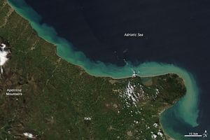
Sediment Flow
Clouds of tan and blue and green line Italy’s eastern shore in this natural-color image from April 6, 2010. The color is sediment billowing out from the shore into the Adriatic Sea. High concentrations of sediment are tan. As the dirt disperses, the water turn pale blue green.
The sediment probably comes from run off after spring rain showers or from melting snow in the Apennine Mountains. In the large image, which shows a broader area, some of the peaks are still capped in snow. Numerous rivers link the mountains to the coast. The rivers are pale, faint tan lines that cut across the green landscape.
The Moderate Resolution Imaging Spectroradiometer (MODIS) on NASA’s Aqua satellite captured this image. The large image is the highest resolution image available, 250 meters per pixel. The image is available in additional resolutions from the MODIS Rapid Response System. Source: NASA. Credit: NASA image courtesy Jeff Schmaltz, MODIS Rapid Response Team at NASA GSFC. Caption by Holli Riebeek.
Ecology
Differentiated from the rest of the Mediterranean Sea, the Adriatic Sea has distinctly higher biological productivity than the balance of the larger basin. Gyres and upwellings contribute to the Adriatic Sea’s high phytoplankton productivity. This primary productiviity is further enhanced by the shallowness of the Adriatic, giving rise to relatively high surface sea temperatiures. The highest levels of productivity occur along the [[coast]s], near major cities, and at river estuaries.
In the Adriatic Sea, coastal water pollution and eutrophication are the chief factors driving change in fisheries yields; overfishing is also an issue. Fish kills have occurred in the northern Adriatic as a result of noxious phytoplankton blooms and anoxic conditions.
See also: Mediterranean Sea large marine ecosystem
Further Reading
- Seas of the world on the Encyclopedia of Earth
- Maritime Briefing: The maritime boundaries of the Adriatic Sea by Gerald Henry Blake, Duško Topalovi, Clive H. Schofield, and Mladen Klemeni, University of Durham, 1996
- Physical Oceanography of the Adriatic Sea: Past, Present and Future by Benoit Cushman-Roisin , Miroslav Gacic, Pierre-Marie Poulain and , Antonio Artegiani (editors),Springer, 2001 (ISBN: 1402002254)
- A. Artegiani, M. Gacic, A. Michelato, V. Kovacevic, A. Russo, E. Paschini, P. Scarazzato, and A. Smircic. The Adriatic Sea hydrography and circulation in spring and autumn (1985-1987). DSR II, 40:-1180, 1993.
- Miljenko Buljan and Mira Zore-Armanda. Oceanographical properties of the Adriatic Sea. Oceanogr. Mar. Biol. Ann. Rev., 14:-98, 1976.
- T.S. Hopkins, 2001. Abiotic Variability and Biocomplexity in the Northern Adriatic, Some Research Perspectives, Biol. Mar. Medit. 2001, 8(1)
- M. Orlic, M. Gacic, and P. La Violette. The currents and circulation of the Adriatic Sea. Oceanologica Acta, 15:-124, 1992.
- Matthias Tomczak and J. Stuart Godfrey. Regional Oceanography: An Introduction. Pergamon, 1994.
- Artegiani etal. (1997a),
- A. Artegiani, E. Paschini, A. Russo, D. Bregant, F. Raicich, and N. Pinardi. The Adriatic Sea general circulation. Part I: Air-sea interactions and water mass structure. JPO, 27:-1514, 1997a.
- A. Artegiani, E. Paschini, A. Russo, D. Bregant, F. Raicich, and N. Pinardi. The Adriatic Sea general circulation. Part II: Baroclinic circulation structure. JPO, 27:-1532, 1997b.
- Pierre-Marie Poulain. Adriatic Sea circulation as derived from drifter data between 1990 and 1999. J. Marine Systems, 29:-32, 2001.


