Levantine Sea
Seas of the World  The Levantine Sea is most eastern unit of the Mediterranean Sea, and also the most saline portion of the Mediterranean Basin.
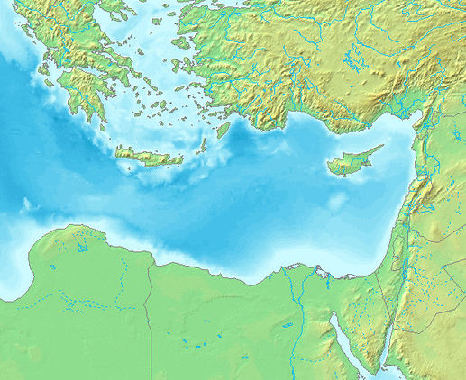
  The Levantine Sea occupies the Eastern Mediterranean.
The Levantine Sea, also known as the Levant Sea, is bounded by the countries of Libya and Egypt at the south; by Israel, Lebanon and Syria to the east; by Turkey at the north; and by the island of Crete and the Aegean Sea at the northwest. In Crete and Libya, this saline water body is usually termed the Libyan Sea.
The maximum depth within the Levantine Basin is approximately 4390 meters; this depth occurs in the Pliny Trench, situated about 80 kilometers south of the Greek island of Crete.
The Leviathan gas field is a significant resource located under the Levantine Basin.
Contents
Geography
The western bound leading to the open Mediterranean Sea is usually construed as a straight line running from the island of Gavdos, somewhat south of Crete, to Libya’s cape Ra’s al-Hilal. Cyprus is the biggest island within the Levantine Sea. The greatest depth of 4384 meters is found in the Pliny Trench, about 80 km south of Crete. The Levantine Sea stretches over an area of 320,000 km. The northern part of the Levantine Sea between Cyprus and Turkey is called Cilician Sea. Also in the north are two large bays: the Gulf of ?skenderun (northeast) and Gulf of Antalya (northwest).
Circulation and Hydrography
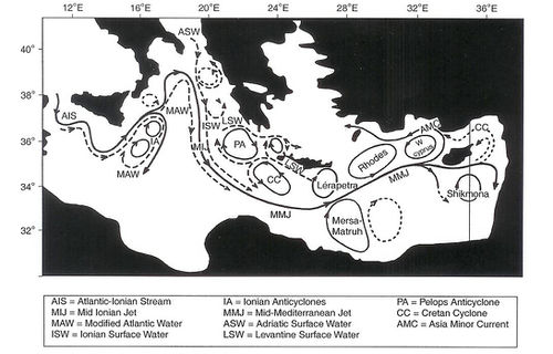
Meteorological and hydrological conditions within the Levantine Sea basin are generally favorable for the convergence and convective sinking of high salinity. The eastern Mediterranean generally, and the Rhodes Gyres more specificlly, are loci of formation of the Levantine Intermediate Water.
 Sub-basin and mesoscale features in the Eastern Mediterranean Sea. Source: Pierre-Yves Dar There are three chief sub-basin eddies within the Levantine Basin, which interact dynamically:
- Mersa Matruh Gyre anticyclonic;
- Shikmona Gyre anticyclonic; and,
- Rhodes Gyre cyclonic.
Furthermore, there are four embedded coherent eddies: (1) Anaximander eddy, (2) Antalya eddy, (3) Cilician eddy, and (4) Lerapetra eddy.
The bifurcating Mid-Mediterranean Jet-flow of the Central Levantine Basin Current and the Asia Minor Current (AMC) feed these gyres and eddies.
Three chief water masses in the northwest Levantine Sea are:
- Modified Atlantic Water (MAW), a water mass formed in the Atlantic Ocean that enters the Alboran Sea via the Sicily Channel and which features a salinity maiximum;
- Levantine Intermediate Water (LIW) which is the most saline water mass of the eastern Mediterranean Basin, and it is formed in late winter at several loci of the Levantine Sea as well as in the southern Aegean Sea; and;
- Eastern Mediterranean Deep Water (EMDW), a mass cooler and not as saline as the LIW.
The EMDW is formed in the Ionian Sea by the admixture of Adriatic Bottom Water (AdBW) that effluxes from the Otranto Strait. The layer that resides at 700 to 1600 metres in depth sandwiched between LIW and EMDW is named the Transitional Mediterranean Water (TMW). In the northern Levantine Sea the nutrient composition is characteristic of an oligotrophic region, the nutrient deficient surface water being separated from the deep and intermediate waters by a transitional layer about 100 to 200 metres thick.
Climate
The climate is characterized by warm, rainy winters and dry, hot summers. Precipitation amounts decrease from west to east, ranging from 1000-1250 millimeters (mm) around Antalya, 600-800 mm in Mersin, Adana, and Iskenderun Bay, 400 mm around Mesopotamia, and lower amounts in the Syrian basin. In the coastal plains of the southern part of the ecoregion, precipitation reaches 600-850 mm around Beirut, Akko, and Zefad, and decreases to about 400 mm in southern Israel.
The relatively harsh climatic conditions and the long history of human settlement constitute two major factors affecting the flora and fauna in this ecoregion. Macrobotanical evidences indicates that deleterious effects of human activities became evident in the region as early as 3000 BC. Since that time, high temperatures, low atmospheric humidity, and poor soil conditions have impeded the vegetation from recovering after human disturbances
Marine Ecosystem
The Levantine Sea has a narrow continental shelf. The entirety of the Mediterranean Sea large marine ecosystem presents a composite structure of environmental conditions, with local areas of upwelling, wind-driven currents, high water temperatures at least in some periods of the year, and nutrient inputs from rivers and human activities. The major inflow into the Mediterranean is nutrient-poor, oxygenated Atlantic surface water through the Strait of Gibraltar, resulting in generally well-oxygenated bottom waters. The highest levels of productivity occur along the coasts, near major cities, and at river estuaries. The lowest productivity levels in the Mediterranean Basin occurs in the Levantine Sea; moreover, the entire Mediterranean Sea is considered a Class III, low (<150 grams of Carbon per square meter per year) productivity ecosystem. The Mediterranean Basin has unusually high biodiversity for a temperate sea. Temperature stratification can occur during extended periods of calm seas, high temperatures, and inflows of freshwater. This separates the warmer, less saline surface water from the deeper, colder and more saline water, resulting in autumnal algal blooms and extended hypoxia or anoxia.
Terrestrial Margin Ecosystem
See main article: Eastern Mediterranean conifer-sclerophyllous-broadleaf forests
Stretching along the coastline of Syria, Lebanon and Israel the[[Eastern Mediterranean conifer-sclerophyllous-broadleaf forests] ]vegetation of this ecoregion can be organized into three main groups: broadleaf sclerophyllus vegetation (maquis); coniferous forests of Aleppo pine (Pinus halepensis) and Callabrian pine (Pinus brutia); and dry oak (Quercus spp.) woodlands and steppe formations. Here, although the Amanus Mountains and the Anti-Taurus Mountains in the north do not belong to this ecoregion, their presence is important because they serve as barriers between this region's western, eastern, and southern parts. Since they affect the distribution of humid weather, these geographical barriers have an impact on species composition and the physiognomy of the vegetation.
Maquis is dominant, especially in the northwestern part of the ecoregion and along the eastern coastal zone of the Levantine Sea. Olive (Olea europea), carob (Cerotonia siliqua), oak (Quercus coccifera), pistachio (Pistacia palestina), lentisk (P. lenticus), and Arbutus andrachne are the principal species of the maquis communities. In addition, however, more than 40 sclerophyllus species also occur here, including: Philyrea latifolia, Pistacia terebinthus, Calicotome villosa, Genista acantha, Rhamnus oleoides, Myrtus communis, Laurus nobilis, Styrax officinalis, and Spartium junceum.
Although the Olea-Ceratonia alliance in the coastal belt is greatly degraded, it still represents the climax community. The Ceratonia siliqua tree layer in particular is so degraded that it is only represented by a few individuals. Olea europea forms good communities around Antalya-Köprülü Kanyon and Adana-Feke.
One of the most widespread and important communities of this ecoregion is the Kermes oak (Quercus coccifera) community. Its high ecological tolerance and capacity to recover in degraded Pinus brutia forests make it one of the most dominant vegetation types. Another oak worthy of mention is the community of the endemic species Quercus aucheri located around Antalya-Kemer-Faselis.
The maquis formation in the southern part of the ecoregion has quite different features from the more common Mediterranean maquis formation. Due to a drier climate and higher temperatures, and since it is highly affected by the Irano-Turanian phytogeographic realm, the southern maquis formation has many deciduous species.
References
- Peter Saundry. 2011. Seas of the world. Topic Ed. C.Michael Hogan. Ed.-in-chief Cutler J.Cleveland. Encyclopedia of Earth
- Roberto Danovaro et al. 2010. Deep-Sea Biodiversity in the Mediterranean Sea: The Known, the Unknown, and the Unknowable. PLoS ONE 5(8)
- Paola Malanotte-Rizzoli, Valery N. Eremeev. 1999. The Eastern Mediterranean as a laboratory basin for the assessment of contrasting ecosystems (Google eBook) Springer. 521 pages
- E.Özsoy and H. Güngör. 1993. The Northern Levantine Sea Circulation Based on Combined Analysis of CTD and ADCP Data, In: P. Brasseur (editor), Data Assimilation: Tools for Modelling the Ocean in a Global Change Perspective, NATO ASI Seeries, Springer-Verlag, Berlin.
- H. ?. Sur, E.Özsoy and Ü. Ünlüata. 1992. Simultaneous Deep and Intermediate Depth Convection in the Northern Levantine Sea, Winter 1992, Ocean.
