Adriatic Bottom Water
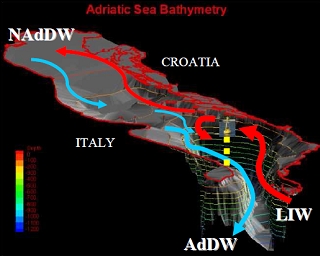
Adriatic Bottom Water (ABW) is a water mass – also known as Adriatic Deep Water – formed in the southern Adriatic Sea that flows south and exits into the Ionian Sea via the Otranto Strait and spreads over the Eastern Mediterranean bottom layer.
The temperature and salinity of ABW are approximately 13.3oC and 38.7 psu, respectively.
There are a couple of competing conjectures as to the origin of the ABW:
Some postulate that North Adriatic Deep Water flowing into the canyon in the Shelf of Bari mixes with Modified Levantine Intermediate Water (MLIW) to form ABW. However, othersposit that contribution of NADW is minor factor, and that the ABW is formed chiefly by the mixing of the surface water in the center of the South Adriatic Pit with the underlying MLIW during periods of deep convection.
Either way, mostresearch confirms that ABW represents the most important component of the bottom water of the entire eastern Mediterranean Sea.
Adriatic Sea
The Adriatic as a whole can be divided into three sub-basins:
- A northernmost shallow basin with the bottom sloping gently to the south and reaching at most 100 metres (m);
- Three pits located along the transversal line off Pescara (one of which is known as the Jabuka Pit), with a maximum depth of 280 m; and
- A southern basin called the South Adriatic Pit (separated from the middle basin by the 170 m deep Palagruza Sill) characterized by approximately circular isobaths, with a maximum depth of about 1200 m in the center. This unit holds the Adriatic Bottom Water.
The bottom rises toward the Strait of Otranto past the southern basin, with the strait having a maximum depth of 780 m, and average depth of 325 m, and a width of about 75 kilometers.
Further Reading
- A. Artegiani, M. Gacic, A. Michelato, V. Kovacevic, A. Russo, E. Paschini, P. Scarazzato, and A. Smircic. The Adriatic Sea hydrography and circulation in spring and autumn (1985–1987). DSR II, 40:1143–1180, 1993.
- M. Orlic, M. Gacic, and P. La Violette. The currents and circulation of the Adriatic Sea. Oceanologica Acta, 15:-124, 1992.
- Matthias Tomczak and J. Stuart Godfrey. Regional Oceanography: An Introduction. Pergamon, 1994.
- A. Artegiani, E. Paschini, A. Russo, D. Bregant, F. Raicich, and N. Pinardi. The Adriatic Sea general circulation. Part I: Air-sea interactions and water mass structure. JPO, 27:-1514, 1997a
- Vittorio Villasmunta, Corso basico di meteorologia,
- Gacic, M., Manca, B.B., Mosetti R., Scarazzato P., and Viezzoli, D., Deep Water Formation Experiment in the Adriatic Sea is being repeated again this Year, Istituto Nazionale di Oceanografia e di Geofisica Sperimentale, 1998