Arctic Cordillera ecoregion (CEC)
| Topics: |
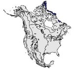
This ecological region occupies the northeastern fringe of the Northwest Territories and Labrador and contains the northernmost mountainous area in North America. The eastern Arctic mountains have some of the most spectacular alpine glacial scenery in the world. The harsh climate, rugged terrain and low biological productivity are among its distinguishing characteristics. With a population of approximately 1,050, this is the least populated Level I ecological region (Arctic Cordillera ecoregion (CEC)) in North America.
Physical Setting
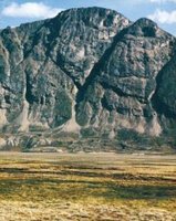
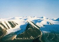
The vast mountain chain of deeply dissected Precambrian crystalline rocks forms the spine of this ecological region. It runs along the northeastern flank of Baffin Island, northward over eastern Devon Island and Ellesmere Island, as far as Bache Peninsula and southward to the Torngat Mountains in Labrador. Elevations range from sea level to over 2,000 meters (m) above sea level. Massive ice caps and valley glaciers mask many of the rugged mountains. The northwestern section takes in ice-covered Grantland and Axel Heiberg mountains, consisting mainly of long ridges of folded Mesozoic and Paleozoic strata, with minor igneous intrusions. To the northwest, these mountains pass abruptly into a narrow, seaward-sloping plateau, and to the east, with decreasing ruggedness, into the elevated dissected edge of Eureka Upland. Ice fields and nunataks are common. The ranges and ridges are interspersed with numerous steep-walled valleys, glaciers and fjords. Valley glaciers extend over much of the higher elevations and often extend to the foot of the mountains. The U-shaped valleys and deep fjords extend many kilometers inland. The valley walls are rocky or covered with colluvial and morainal debris. Almost 75 percent of the landscape is ice or exposed bedrock. As a consequence of continuous permafrost conditions, frozen soils prevail, with surface thawing taking place during the short summer.

The climate is extremely cold and dry in the north, while it is somewhat milder and more humid in the southernmost portions of the region. The mean summer temperature ranges from –6°C to –2°C. Summers are short and cool, and the growing season is enhanced by long periods of daylight. The mean winter temperature ranges from –35°C in the mountains of Ellesmere Island to –16°C in northern Labrador. Precipitation varies from 200 millimeters (mm) in the north to over 600 mm in Labrador.
Biological Setting
Because of the extremely cold, dry climate, along with the ice-fields and lack of soil materials, the high and mid-elevations are largely devoid of significant [[population]s] of plants and animals. In the more sheltered valleys at low elevations and along coastal margins, the vegetative cover is more extensive, consisting of herbaceous and shrub-type communities. Isolated “oases” of biological activity include sheltered stream banks and coastlines, and south-facing slopes watered by late melting snow. Lichens are associated with rock fields throughout.

The upper elevations are largely devoid of large terrestrial mammals. Polar bears are common in some [[coastal] areas] where biological productivity is much higher. Arctic hare, Arctic fox, ermine and the collared lemming are among the few species found throughout the area in limited numbers. Usually sheltered areas provide productive plant habitats. The adjacent marine environment is typified by walrus, ringed and bearded seals, narwhal, bowhead, and other species of whale. Large concentrations of seabirds congregate in the warmer coastal margins, including the northern fulmar, thick-billed murres, black-legged kitiwakes, common ringed plover, hoary redpoll and snow bunting.
Human Activities
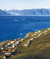
This is the most sparsely populated ecological region in North America. The total population is only 1,050, found primarily in the communities of Clyde River and Broughton Island. Except for hunting, trapping and fishing, the range of human activities is limited. Some tourism is promoted in places such as Auyuittuq National Park Reserve and Bylot Island.
| Disclaimer: This article is taken wholly from, or contains information that was originally published by, the Commission for Environmental Cooperation. Topic editors and authors for the Encyclopedia of Earth may have edited its content or added new information. The use of information from the Commission for Environmental Cooperation should not be construed as support for or endorsement by that organization for any new information added by EoE personnel, or for any editing of the original content. |