Wiregrass Ridge (Bailey)
This subsection is a steep mountainous area south-southeast of Orick. It is a narrow strip bounded on the east-northeast by the Grogan fault, which is along Redwood Creek, and on the west-southwest by the Bald Mountain fault. It has a temperate, humid climate. There is substantial oceanic influence on climate, including summer fog. MLRA 4b.
Contents
Lithology and Stratigraphy
This subsection is dominated by Jurassic and Cretaceous Franciscan sedimentary, minor volcanic, and metamorphic rocks, including the schist of Redwood Creek. They are intensely folded and faulted of the Eastern Belt. There are small areas of recent alluvium along Prairie and Redwood Creeks.
Geomorphology
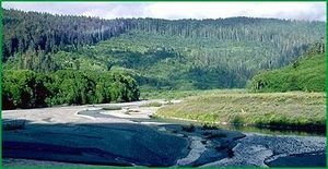
This is a subsection of mountains with rounded ridges, steep and moderately steep sides, and narrow canyons. Most of the mountains are elongated in north-northwest to northwest directions and have subequal summits with increasing elevation toward the interior. The valleys of Prairie and Redwood Creeks are broad enough near their mouths to contain appreciable floodplain. The subsection elevation range is from sea-level up to 4637 feet on Mt. Andy. Mass wasting and fluvial erosion are the main geomorphic processes.
Soils
The soils are mostly Typic Humitropepts and less extensive Orthoxic Tropohumults. The soils are leached free of carbonates and the older ones are strongly acid. The soil temperature regimes are predominantly isomesic. Soil moisture regimes are mostly udic.
Vegetation
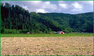
The predominant natural plant community is Redwood series. Red alder series is common in riparian areas.
Characteristic series by lifeform include:
- Grasslands: Introduced perennial grassland series, Pacific reedgrass series.
- Shrublands: Coyote brush series, Salal - California huckleberry series.
- Forests and woodlands: Black oak series, Red alder series, Redwood series, Tanoak series, Western hemlock series.
Climate
The mean annual precipitation is about 60 to 80 inches. Most is rain at lower elevations and some is snow at higher elevations. Mean annual temperature is about 40° to 53°F. The mean freeze-free period is about 225 to 300 days.
Surface Water
Runoff is rapid and many of the smaller streams are dry by the end of the summer. Natural lakes are absent. Brackish water lagoons are common along the coast.
Return to Northern California Coast