Willandra Lakes Region, Australia
Contents
- 1 Geographical Location
- 2 Date and History of Establishment
- 3 Area
- 4 Land Tenure
- 5 Altitude
- 6 Physical Features
- 7 Climate
- 8 Vegetation
- 9 Fauna
- 10 Cultural Heritage
- 11 Local Human Population
- 12 Visitors and Visitor Facilities
- 13 Scientific Research and Facilities
- 14 Conservation Value
- 15 Conservation Management
- 16 Further Reading
Geographical Location
The Willandra Lakes Region (34°S, 143°E) is a World Heritage Area located in the Murray Basin in southwestern New South Wales. The area is divided diagonally in a southwestern to northeastern direction by the boundary of Balranald Shire and Wentworth Shire. 34°S, 143°E
Date and History of Establishment
Only a small portion of Willandra Lakes Region is legally protected, namely Mungo National Park which was gazetted in 1979, under the New South Wales National Parks and Wildlife Act, 1974. The size of the national park was increased by 13,000 hectare (ha), to its current size, under a proclamation published in the Government Gazette No. 51 of 27 March 1986. Willandra Lakes Region was inscribed on the World Heritage List in 1981. The original boundary of the World Heritage Property, encompassing 600,000 ha, was modified and reduced to its current size in 1995.
Area

240,000 ha, including Mungo National Park (27,847 ha).
Land Tenure
Government of the State of New South Wales.
Altitude
Approximately 70 meters (m) at the center of the region.
Physical Features
The Willandra Lakes Region comprises a system of dry lakes formed during the lower Tertiary (Geologic time), when marine transgressions in the Murray Basin deposited calcareous sand, marl and limestone. These were overlain by sands and dunefields in the Quaternary (Geologic time). The region is characterized by linear dunes, whose west to east orientation reflects the controlling wind system. Although these relict features were stabilized by vegetation, they were reactivated around 18,000 Before Present (BP) to 16,000 BP and were subsequently re-established.
The interconnected lake basins were fed by a former tributary of the Lachlan River known as Willandra Billabong Creek. The six major lakes and numerous smaller depressions covered an area of 1,088 sq. kilometers (km), and ranged in size from ephemeral ponds to Lake Garnpung, which was over 10 m deep and over 500 sq. km. The formation of crescent lunette dunes on the eastern side of the lakes has been dated to at least 40,000 years to about 15,000 years ago, with an intensive period of dune building between 18,000 and 16,000 years ago.
Climate
Experiences a semi-arid climate.
Vegetation
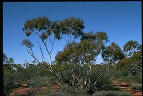
Comprises a semi-arid vegetation community, characterized by sparse, scattered scrub, grasslands and woodland interspersed with sandplains and dunes. Small mallee eucalpts Eucalyptus oleosa and E. dumosa dominate much of the woodland, whilst white cypress pine Callitris columellaris and associated understory of porcupine grass Trioda irritans occur on sandy areas.
Fauna
Some 20 mammalian species have been recorded, including red and grey kangaroos, echidnas and several species of bat.
Cultural Heritage
Numerous radiocarbon dates establish that humans exploited the region at least 30,000 years ago. Archaeological discoveries include a 26,000 year old cremation site; a 30,000 year old ochre burial site; the remains of giant marsupials; and grindstones or mortars from a period 18,000 years ago, which were used to crush wild grass.
Local Human Population
Approximately 40.
Visitors and Visitor Facilities
Annual visitation to Mungo National Park is approximately 38,000.
Scientific Research and Facilities
Considerable research has been undertaken. A Mungo workshop was held in 1989 which involved compiling research and the presentation of papers on archaeology, and geomorphology. The region contains the remains of hearths, some dated as being 30,000 years old, which because of their resistance to erosion, provide an ideal source for palaeomagnetic measurements. Research here has determined that there was a variation of 120° in earth magnetism some 30,000 years ago. Consequently, the area remains one of the benchmarks in studies of changes in earth magnetism. The 1996 Plan of Management provides a bibliography covering geology/geomorphology, biodiversity/ecology, archaeology, social value, history, linguistics and aboriginal history, management, unpublished reports, and theses and dissertations.
Conservation Value
The Willandra Lakes provide excellent conditions for recording the events of the Pleistocene Epoch, demonstrating how non-glaciated zones responded to the major glacial-interglacial fluctuations. They demonstrate the close interconnection between landforms and paedogenesis, palaeochemistry, climatology, archaeology, archaeomagnetism, radio-carbon dating, palaeoecology and faunal extinction.
Conservation Management
Of the Willandra Lakes Region, approximately 90% is divided into 16 pastoral stations, which are leased from the Crown and administered by the Department of Land and Water Conservation. The remaining land comprises Mungo National Park and is managed by the National Parks and Wildlife Service (NPWS). Administration of the whole region is jointly undertaken by these two state agencies.
Draft management plans have been completed for Mungo National Park and Willandra Lakes Region. The Commonwealth and New South Wales Governments have established a new administration and management planning arrangement for the World Heritage property. This includes the formation of a Ministerial Council, a Community Management Council and a Technical and Scientific Advisory Committee. A Strategic Issues Document has been completed, and was the first step in the development of a comprehensive management plan. A Plan of Management has been completed and was released in February 1996. A Regional Environmental Plan is also being prepared and will provide statutory effect to the Plan of Management.
Management Constraints
Protection and conservation of World Heritage values is addressed in the new Plan of Management. This document identifies the values of the area and specifies broad strategies to protect and conserve these values. Site specific activities within Mungo National Park are managed by the National Parks and Wildlife Service. Individual Property Plans are currently being developed for leasehold properties in the World Heritage Area and are expected to be completed by the middle of 1996. These plans will determine site specific activities for leasehold land. Detailed protocols for specific activities on all land within the World Heritage Area are also in the process of being developed and will be included into the Plan of Management.
Staff
No information.
Budget
No information.
Further Reading
- Anon. (1989). Information update on the cultural sites on the World Heritage List: Willandra Lakes Region of Western New South Wales. Department of the Arts, Sport, the Environment, Tourism and Territories, Canberra, Australia. 3 pp.
- Australian Heritage Commission (1980). Nomination of the Willandra Lakes Region for inclusion in the World Heritage List. 28pp.
- Fatchen, T.J. et al. (1992). A Draft Plan of Management for the Willandra Lakes Region. Department of Conservation and Land Management/National Park and Wildlife Service.
- Milne, A.K. and O'Neill, A.L. (1990). Mapping and monitoring land cover in the Willandra Lakes World Heritage region New South Wales, Australia. International Journal of Remote Sensing 11(11): 2035-2050.
- NPWS (1989). A Draft Plan of Management for Mungo National Park. National Parks and Wildlife Service of New South Wales, Sydney.
- Thorman, R. (1994). Willandra Lakes Region World Heritage Property Strategic Issues Document October 1994. Prepared for the Department of the Environment Sport and Territories. 53 pp.
- Tidemann, C.R. (1988). A survey of the mammal fauna of the Willandra Lakes World Heritage region, New South Wales, Australia. Australian Zoologist 24(4): 197-204.
- World Heritage Australia (1996). Willandra Lakes Region World Heritage Property: Plan of Management. Prepared for The Commonwealth Department of the Environment Sport and Territories. Includes bibliography.
| Disclaimer: This article is taken wholly from, or contains information that was originally published by, the United Nations Environment Programme-World Conservation Monitoring Centre (UNEP-WCMC). Topic editors and authors for the Encyclopedia of Earth may have edited its content or added new information. The use of information from the United Nations Environment Programme-World Conservation Monitoring Centre (UNEP-WCMC) should not be construed as support for or endorsement by that organization for any new information added by EoE personnel, or for any editing of the original content. |