Western Indian Ocean Islands and land resources
Contents
- 1 Introduction The extent of land area in the WIO island countries and the population (Source: FAOSTAT 2005, UNDP 2004, WRI 2005) The four island countries of the Western Indian Ocean (WIO) sub-region have a total land area of 59.2 million hectares (ha), 99 percent of which is Madagascar, the fourth largest island country in the world. Large parts of the sub-region are mountainous, rugged and dry. (Western Indian Ocean Islands and land resources)
- 2 Endowments and opportunities
- 3 Challenges faced in realizing opportunities for development
- 4 Further reading
Introduction The extent of land area in the WIO island countries and the population (Source: FAOSTAT 2005, UNDP 2004, WRI 2005) The four island countries of the Western Indian Ocean (WIO) sub-region have a total land area of 59.2 million hectares (ha), 99 percent of which is Madagascar, the fourth largest island country in the world. Large parts of the sub-region are mountainous, rugged and dry. (Western Indian Ocean Islands and land resources)
Endowments and opportunities
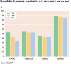 Western Indian Ocean countries: agricultural areas (as a percentage of total land area)
(Source: FAO 2003)
The main use of land is agriculture, although this has been steadily declining due to pressures from population growth and industrial development. As shown in the figure to the right, only in Madagascar and the Seychelles is the majority of land still used for agriculture. Agriculture contributes 3 percent and 6 percent of the GDP for the Seychelles and Mauritius, respectively, and 35 percent and 41 percent of the GDP for the Comoros and Madagascar, respectively.
The pattern of agriculture varies between the islands depending on climatic conditions for producing particular crops. The islands, however, remain net importers of cereals and staples such as rice and potatoes. Agricultural expansion and tourism were the main growth factors for Madagascar, Mauritius and the Seychelles.
Challenges faced in realizing opportunities for development
Population growth in WIO countries puts pressure on land. Population growth in Madagascar is predicted to be 2.5 percent per annum for the period 2003-2015: with the current population at 17.6 million this will give an increase to 23.8 million by 2015. In 2003, population density in Madagascar was 29.9 people per km2. In contrast, population density in Mauritius was 604.5 people per km2 – the highest in Africa, with the population expected to grow at 0.8 percent per annum.
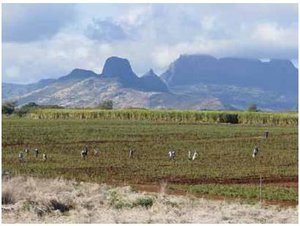 Sugar cane fields, Mauritius.
(Source: A. Mohamed)
In Madagascar, frequent drought conditions and seasonal floods from cyclones create food emergencies. Climate change will also increase the pressure on land resources, through less predictable weather conditions and the impact of sea-level rise on the coastal regions, especially in the smaller islands.
The WIO islands are challenged to respond to the NEPAD policy to combat land degradation. This is being done through the Indian Ocean Commission’s (IOC) Environment Programme which calls upon each of the four countries to develop and implement action plans to promote sustained livelihoods and mitigate the past impact of land degradation on other resources. In Madagascar, an environmental awareness programme supports the national conservation strategy, focusing on habitat and biodiversity protection, the creation of a national environmental fund with research projects on land mapping and management, environmental education, training and institutional support.
The sub-region should also develop irrigation; over one million hectares of land has potential for irrigation. In a sub-region where droughts are prevalent, often destroying crops and exacerbating food insecurity, irrigation could be a key factor in enhancing food security.
Enhancing and extending property rights are key challenges for promoting development and conservation. Mauritius and the Seychelles have established more equitable mechanisms for distribution of land with effective protection of land rights. In Mauritius, 90 percent of the land is privately-owned and more than 85 percent of people live in owner-occupied property with government registered deeds. By contrast, in Madagascar, landownership has been without enforceable land registration, creating difficulties in its use as collateral for investment. This is now changing and land registration is being introduced as part of a general policy to improve land use, to reduce land degradation and short-term exploitation, and to promote the development of investment.
Controlling and managing pollution is important for the tourism sector which is an important part of the economy.
Further reading
- FAO, 2003. Forestry Outlook Study for Africa – African Forests: A View to 2020. African Development Bank, European Commission and the Food and Agriculture Organization of the United Nations, Rome.
- FAO, 2005. State of the World’s Forests 2005. Food and Agriculture Organization of the United Nations, Rome.
- UNDP, 2004. Human Development Report 2004: Cultural Liberty in Today’s Diverse World. United Nations Development Programme, New York.
- UNDP, 2005. Human Development Report 2005: International Cooperation at a Crossroads – Aid,Trade and Security in an Unequal World. United Nations Development Programme, New York.
- UNEP, 2006. Africa Environment Outlook 2
|
|
| Disclaimer: This article is taken wholly from, or contains information that was originally published by, the United Nations Environment Programme. Topic editors and authors for the Encyclopedia of Earth may have edited its content or added new information. The use of information from the United Nations Environment Programme should not be construed as support for or endorsement by that organization for any new information added by EoE personnel, or for any editing of the original content. |