Water profile of Thailand
Contents
Geography and Population
 Map of Thailand. (Source: FAO)
 Thailand covers an area of 513,120 square kilometers (km2) in Southeast Asia. Administratively, the country is divided into 72 changwats (provinces), 4 regions, and the Bangkok Metropolitan area. The four regions correspond approximately to the physiographical regions of Thailand: the northern region is mountainous with dense forests; the northeast is dry and consists of a plateau which borders the Mekong River; the central region is an extensive plain subject to flooding; and the southern part consists of a peninsula.
About 26.79 million hectares (ha) are considered as suitable for agricultural production, and in 1995 the cultivated area was estimated at 20.45 million ha, or 40 percent of the total area. Of this total, 17.09 million ha, or 84 percent of the total cultivated area, were under annual crops (mainly paddy rice) and the remaining 3.36 million ha were under permanent crops.
The total population was estimated at 58.70 million inhabitants in 1996 (80 percent rural). The annual population growth rate was estimated at 1.5 percent in 1993. The population density is about 114 inhabitants/km2.
The agriculture sector accounted for 11.5 percent of gross domestic product (GDP) in 1991, and agricultural exports represented 23 percent of total export earnings. In 1996, 55 percent of the total labor force was employed in the agriculture sector.
Climate and Water Resources
Climate
The climate is mainly governed by the alternation between the southwest monsoon, which brings heavy rainfalls (from May to October), and the northeast monsoon, which is comparatively dry and cool (from October to February). The transitional period is characterized by heavy thunderstorms.
The average annual rainfall is estimated at 1,485 millimeters (mm). It ranges from 1,100 mm in the central plain and the northeast of the country to 4,000 mm in the southern peninsula near the Andaman Sea.
Water Resources
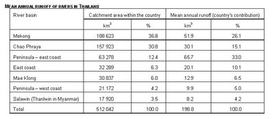 Table 1: Mean annual runoff of rivers in Thailand. (Source: FAO)
 Thailand can be divided into seven river basins, but in the literature it is generally divided into 25 sub-basins. Table 1 shows the characteristics of the seven major river basins and indicates the total surface water resource of the country, i.e., 198.8 cubic kilometers per year (km3/year).
Aquifer recharge from rainfall is estimated at 41.9 km3/year (about 5-6 percent of the total precipitation). Approximately 30.7 km3/year are estimated to return to the river system and are included in the surface water resources. The total internal water resources of Thailand are therefore estimated at 210 km3/year.
International Rivers and Agreements
Thailand shares three rivers with its neighbors:
- The Mekong River forms the border with Lao People's Democratic Republic (Lao PDR) in the north and east. About 18 percent of the total Mekong catchment area is located in Thailand. Thailand has been a member of the Mekong River Commission since its inception in 1957, and the commission is located in Bangkok. The latest international agreement concerning the lower Mekong River was signed in April 1995 by the four riparian countries: Thailand, Lao PDR, Cambodia, and Vietnam. This agreement concerns cooperation for the sustainable development of the lower Mekong River basin, but does not propose any sharing of water between the riparian countries.
- The Salawin River is on the northwestern border with Myanmar. No agreement has yet been signed, but a working group is assessing the irrigation and hydropower potential of the Salawin River and its tributaries.
- The Kolok River, on the southern border with Malaysia.
The Mekong and Salwin rivers constitute an additional external resource for Thailand which has been estimated as half the discharge of the rivers deducted by the contribution of the countries, i.e., 200/2 (half the Salwin discharge) - 8.156 (contribution of Thailand to Salwin) + 324.45/2 (half the Mekong discharge) - 51.9 (contribution of Thailand to Mekong in the border reach) = 199.9 km3/year.
Total Renewable Water Resources
By adding the internal and external resources together, the total renewable water resources are estimated at approximately 410 km3/year.
Lakes and Dams
The total dam capacity is estimated at 85 km3, which is about 43 percent of the annual runoff. However, a lot of dams have been overdesigned compared with the annual recharge obtainable. There are four categories of dams in Thailand:
- Large dams with a hydropower component are built by the Electricity Generating Authority of Thailand (EGAT), the Royal Irrigation Department (RID), or the Department of Energy Development and Promotion and managed by the EGAT. Their total capacity is estimated at 53.46 km3. Hydropower generation is important in Thailand as its 21 hydropower plants account for 18 percent of installed capacity and 5 percent of energy production. However, all these dams are multipurpose dams, and the irrigation component receives priority over the other components.
- Large dams, with no hydropower component, and therefore mainly destined for irrigation, are operated by the RID. Their total capacity was estimated at 31.4 km3 in 1995.
- Small dams, which cost about US$200,000, are developed by the Office of Accelerated Rural Development under the Ministry of Interior for irrigation, livestock, and domestic purposes.
- Small dams of around 100,000 m3 each, developed by the Land Development Department of the Ministry of Agriculture and Co-operatives. They cost about US$120,000 each and are used for agricultural and domestic purposes. Their total capacity is estimated at 0.1 km3. Each year, about 200 such dams are constructed or rehabilitated.
Water Withdrawal
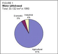 Figure 1: Water withdrawal in Thailand. (Source: FAO)
 The total water withdrawal was estimated at 33.13 km3 in 1990, of which 91 percent was for agricultural purposes (Figure 1). It is reported that domestic and industrial water withdrawals are increasing substantially every year.
Wastewater treatment is not common. Industrial wastewater is generally discharged into rivers and canals. About 833 million m3 of wastewater were produced in 1992. In 1995, some 35 million m3 of wastewater were treated. Numerous wastewater treatment projects are being developed in the Bangkok metropolitan area. There is no reuse of treated wastewater in Thailand.
Irrigation and Drainage Development
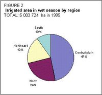 Figure 2: Irrigated area in wet season by region. (Source: FAO)
 The irrigation potential for the wet season can be roughly estimated at 12 million ha, considering both soil and water availability but excluding basin transfers. The total area suitable for irrigation is estimated at 16 million ha.
Irrigation through river diversion and from reservoirs started in the north seven centuries ago. In modern times, canal construction for irrigation started at the beginning of the century, in parallel with the creation of the RID. The aim was to maintain water in canals for irrigation and navigation, and to drain paddy fields during periods of flooding. Irrigation has traditionally been supplementary irrigation for the wet season. It is only recently that schemes have been designed for dry season irrigation.
The area equipped for wet season irrigation was estimated at 5,003,724 ha in 1995. Thailand develops 120,000 ha of irrigation each year (2 percent of the equipped area; Figure 2).
These irrigated areas can be divided into five categories (Figure 3):
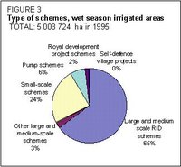 Figure 3: Types of schemes, wet season irrigated areas. (Source: FAO)
 - Large and medium-scale schemes (3,381,460 ha in 1995). Most of these schemes (around 650 schemes covering an irrigated area of 3,255,124 ha, or 96 percent) have been designed constructed and managed by the RID since their inception. They are mainly concentrated in the central plain within the Chao Phraya river system, which is called the rice bowl of Thailand. Some of them are pump schemes. The remaining 4 percent (or 65 projects covering 126,336 ha) have not been implemented fully by the RID, but only partially as they rely on dams constructed by the EGAT.
- Small-scale schemes. These schemes are also called private schemes. They may have been designed and built by the RID, by other departments, by non-governmental organizations (NGOs), or by the private sector. They should be farmer driven and managed, but farmers often require RID assistance for maintenance once the cost exceeds US$4,000. The total area of these 7,246 schemes is about 1.21 million ha.
- Pump schemes. These schemes have been implemented mainly in the northeast (50 percent of such irrigated areas) and north (35 percent) by the Department for Energy Development and Promotion, and are still managed with its assistance. The equipped area for wet season irrigation was about 318,630 ha in 1995. Only 58,240 ha (18.2 percent) were also irrigated during the dry season, of which 22 percent was for rice cultivation.
- Royal development projects. These projects have been implemented and managed by the RID after a personal decision of the king. They are supervised by the Office of the Co-ordinating Committee for Royal Development Projects. They are generally small scale and are spread throughout the country, mainly in remote areas. Some 347 projects cover a total area equipped for irrigation of 79,039 ha.
- Self-defense village projects. These are irrigated schemes implemented in military-sensitive areas, and managed by the RID. Their total equipped area for wet season irrigation is 16,377 ha in 171 projects.
In 1988, the area actually irrigated was estimated at 91 percent of the equipped area. All schemes are irrigated by surface irrigation: sprinkler and drip irrigation are at an experimental stage only on fruit trees. Generally, surface water is used, but in the Sukhotai region, some 6,758 ha (in 1990) rely on pumping groundwater for irrigation. The potential for irrigation by groundwater was estimated at 200,000 ha in 1985, though the latest estimate for groundwater irrigation is about 12,000 ha.
Early systems were designed to operate at full capacity only in the wet season. The canal capacities and control regulators are inadequate for the increasing demand for dry season irrigation. Furthermore, irrigation water demand has to compete with demand from other sectors. This becomes a sensitive issue during the dry season. A certain flow of water must be maintained for navigation, to prevent saltwater intrusion, and to supply water for domestic and industrial purposes in the Bangkok area. In the dry season, water resources can no longer meet the increasing water demand from all sectors, and particularly for the irrigation subsector which needs to withdraw more and more water because of the development of dry season irrigation. This water competition has led to poor agricultural performance in recent dry seasons.
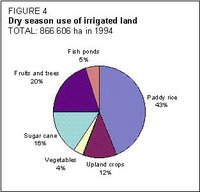 Figure 4: Dry season use of irrigated land. (Source: FAO)
 Dry season irrigation is practiced on 18 percent of the equipped area. Figure 4 shows the different crops grown on irrigated land in the 1993-1994 dry season. Part of the irrigated land is used as fish ponds during the dry season.
Small-scale projects are those which can be completed within one year and without land compensation. Initially their cost is generally less than US$400,000. The schemes which cannot be completed within one year or which need land compensation are considered medium scale. They are classed as large scale if there is a storage capacity of more than 100 million m3 or if they can irrigate at least 80,000 rais (12,800 ha). Generally, large-scale projects cost more than US$8 million, but this figure is not considered a criteria.
The main irrigated crop is paddy during the wet season, and its average yield for the wet season was 3.5 t/ha in 1993-1994.
On average, the RID spends US$45/ha/year for operation and maintenance (O&M). Normally, the RID is responsible for the maintenance of main and secondary canals, while the tertiary and field canals are the responsibility of farmers. Water User Groups (WUGs) have not yet been set up on a wide scale, except in the north where farmers were used to forming groups in order to repair and maintain the traditional weirs.
In the northeast of the country, 10 percent of the irrigated land is affected by salt. The presence of the salt-bearing nature of the soil parent material has been identified as the primary cause for this. Other activities such as irrigation could be classed as secondary causes for accelerating this locally. Many programs have been launched in order to correctly manage cash crops and paddy on saline soils. Salinization is now reported to be affecting large areas in the coastal parts of the central plain.
The main water-borne diseases are acute diarrhea (affecting 1.48 percent of the population), dysentery (0.14 percent), and enteric fever (0.03 percent). Malaria, as a water-related disease, affects 0.12 percent of the population.
Institutional Environment
At present, 38 ministerial departments under 10 ministries, 1 independent agency and 6 national committees are involved in water resources development, with responsibilities for water policy, irrigation, domestic and/or industrial water supply, fisheries, flood alleviation, hydropower generation, navigation, or water quality.
The National Water Resources Committee (NWRC), under the Office of the Prime Minister, is responsible for setting a policy to develop water resources throughout the country.
The National Economic and Social Development Board is responsible for economic planning.
The Department of Mineral Resources, under the Ministry of Industry, monitors groundwater resources, while surface water monitoring is mainly carried out by the Department of Energy Development and Promotion under the Ministry of Science, Technology and Environment, and the RID, which has its own network.
Many departments or agencies are involved in water supply for domestic or industrial purposes. The main one is the Metropolitan (or Provincial, outside Bangkok) Waterworks Authority. Wastewater treatment and water quality are mainly the responsibility of the Ministry of Science, Technology and Environment.
Large dams are operated either by the RID or by the EGAT, while small dams have been developed by the Land Development Department or the Office of Accelerated Rural Development (under the Ministry of Interior).
The Harbour Department is in charge of protecting inland waterways, and of issuing licenses for navigation.
Irrigation is managed by the RID for public schemes, or by the Department of Energy Development and Promotion for the electric pumped schemes. The RID is the supervising agency for private irrigation.
A groundwater act adopted in 1987 defines the responsibilities, rights, and duties of each of the various parties involved. In May 1998, a national water resources act was awaiting cabinet approval. This act should establish the NWRC as the coordinating agency for water resources development.
Although work began some years ago on a national water resources mater plan for water resources development in the 25 river basins, this work has come to a standstill due to lack of funds.
Trends in Water Resources Management
There are numerous water issues in Thailand. Bangkok faces problems of both too much and too little water. Flooding occurs frequently in the wet season due to low average ground level, high tides, and inadequate drainage. The Metropolitan Waterworks Authority is unable to supply water to meet all domestic and industrial demand. As a result, in the outskirts of Bangkok, private and industrial abstraction of groundwater exceeds the safe yield of the aquifer. This accelerates the rate of land subsidence (5-10 cm/year), which in turn aggravates the problem of flooding. Indeed, subsidence has caused some parts of the drainage systems to be below the normal water level and has rendered them ineffective.
The minimal discharge to maintain a water level of 1.7 m for navigation (this means 300 m3/s released in the navigation channel from Nakhon Sawan to the Chao Phraya dam, and 80 m3/s downstream of the dam) cannot be maintained due to large amounts of water diverted from the river for dry season irrigation in the northern and central regions. This reduced the volume of inland waterway transport fivefold between 1978 and 1990. The volumes of water released by the Bhumipol and Sirikit dams are increasingly important to prevent saltwater intrusion, even if they do not meet the navigation demand.
A lot of sites for dams have been identified in order to supply more water to the Chao Phraya River. However, nearly all the suitable sites for large-scale projects have been already exploited. The remaining undeveloped potential sites are either in heavily populated areas or in national park reserves. The resettlement of population and environmental issues are so sensitive that no decision has been taken concerning such dams, even though detailed design studies have been ready for more than 15 years in some cases. The Kaeng Sua Then and the Nam Choan projects have been a cause of conflict between developers and conservationists. It seems increasingly clear that there will be less scope for the development of such large-scale projects in the future.
There is a great need for water (Society and water resources) in the central region for both irrigation and urban water supply. Most of the water used in the central region comes from the northern region. This follows a set of rules established when the main needs were in the central region. In the last few years, there has been an increasing demand for water, especially in the irrigation sector, in the northern region. In the national master plan, the RID has identified 463 projects to be carried out in the period 1997-2006, covering an irrigated area of approximately 1.53 million ha with a storage capacity of 12 km3 to be developed for a total estimated cost of US$3,600 million. If the observed trend continues, and if all projects are implemented, a point will be reached in the near future where water released from the northern region, after satisfying requirements there, will not be sufficient to meet the irrigation water demand in the central region.
To address this problem, the Government has launched many programs to both reduce demand and increase the resources available. To reduce demand, the RID will encourage and increase water use efficiency both at farm and scheme levels. Furthermore, the implementation of water fees after the adoption of the new water law should encourage farmers to reduce wastage. The ongoing national economic and social development stresses the need for a more efficient use of water, and in particular the importance of collecting water fees in irrigated agriculture to avoid wastage. Agricultural water fees should cover only O&M costs, while for the other sectors (domestic and industrial) the fees should also take account of the construction and maintenance costs of water distribution systems.
To increase the available resources, inter-basins transfer projects are being studied and implemented. One such project already exists, diverting water from the Mae Klong River to the Chao Phraya central plain. Other more politically sensitive projects, such as diversion of water from the Mekong, Mae Kok, and Mae Ing rivers to the Yom and Nan rivers, are still at the level of feasibility studies. Groundwater use for irrigation is also a possibility. However, the experiments carried out by the RID have not yielded satisfactory results to date, except in the Sukhotai region where the aquifer has an important yield. Desalination or re-use of treated wastewater have still not been envisaged.
In order to solve the problem of competition between sectors, some studies have been carried out in order to establish a water rights market where all parties would be able to trade water rights. This would stabilize water demand but would have important negative consequences on agriculture.
Water resources development lacks a comprehensive planning and coordination of all the actions carried out in the sector by the different agencies. As proposed in the draft water law, the promotion of the NWRC as the leading agency in terms of water policy definition would address this issue. Furthermore, a committee on water allocation by river basin should be established as a forum for all water users, and to develop seasonal water allocation plans. The master plan for water resources development will provide a framework for all activities carried out by the various agencies.
Further Reading
- Water Resources and Freshwater Ecosystems: Thailand. Earthtrends.
- Population and Socioeconomic Situation in the Chao Phraya Basin. UNESCO.
- Irrigation. US Library of Congress.
| Disclaimer: This article is taken wholly from, or contains information that was originally published by, the Food and Agriculture Organization. Topic editors and authors for the Encyclopedia of Earth may have edited its content or added new information. The use of information from the Food and Agriculture Organization should not be construed as support for or endorsement by that organization for any new information added by EoE personnel, or for any editing of the original content. |