Water profile of Syria
Contents
Geography and population
Syria, with a total area of 185,180 km2, is bordered in the north by Turkey, in the east and southeast by Iraq, in the south by Jordan, in the south-west by Israel and in the west by Lebanon and the Mediterranean Sea. Administratively, the country is divided into 14 governorates, one of which being the capital Damascus.
The country can be divided into 4 physiographic regions:
- the coastal region between the mountains and the sea;
- the mountains and the highlands extending from north to south parallel to the Mediterranean coast;
- the plains, or interior, located east of the highlands and including the plains of Damascus, Homs, Hama, Aleppo, Al-Hassakeh and Dara'a;
- the Badiah and the desert plains in the south-eastern part of the country, bordering Jordan and Iraq.
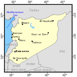 Map of Syria. (Source: FAO-Forestry)
 In 1993, the cultivable land was estimated at 5.94 million ha, or 32% of the total area of the country. The cultivated land was estimated at 4.94 million ha, which is 83% of the cultivable area. Of this area, 4.27 million ha consisted of annual crops and 0.67 million ha consisted of permanent crops. About 62% of the cultivated area is located in the three northern governorates Aleppo, AlReqqa and Al-Hassakeh, representing only 33% of the total area of the country.
The total population is 14.6 million (1995), of which 48% is rural. Actual population growth is 3.3%. In 1993, agriculture employed around 22.5% of the total labor force, accounted for nearly 28% of gross domestic product (GDP) and 60% of non-oil exports.
Climate and water resources
Climate
Syria's climate is Mediterranean with continental influence: cool rainy winters and warm dry summers, with relatively short spring and autumn seasons. Large parts of Syria are exposed to high variability in daily temperature. The maximum difference in daily temperature can be as high as 32°C in the interior and about 13°C in the [[coast]al region]. Total annual precipitation ranges from 100 to 150 mm in the north-west, 150 to 200 mm from the south towards the central and east-central areas, 300 to 600 mm in the plains and along the foothills in the west, and 800 to 1,000 mm along the coast, increasing to 1,400 mm in the mountains. The Average annual rainfall in the country is 252 mm giving 46.6 km3.
Water resources
There are 16 main rivers and tributaries in the country, including 6 main international rivers:
- the Euphrates (Al Furat), which is Syria's the largest river. It comes from Turkey and flows to Iraq. Its total length is 2,330 km, of which 680 km are in Syria;
- the Afrin in the north-western part of the country, which comes from Turkey, crosses Syria and flows back to Turkey;
- the Orontes (El-Ass)) in the western part of the country, which comes from Lebanon and flows into Turkey;
- the Yarmouk in the south-western part of the country with sources in Syria and Jordan and which forms the border between these two countries before flowing into the Jordan River;
- the El-Kebir with sources in Syria and Lebanon and which forms the border between them before flowing to the sea.
- the Tigris, which forms the border between Syria and Turkey in the extreme north-eastern part.
The natural average surface runoff to Syria from international rivers is estimated at 28.73 km3/year. If we include 15.75 km3 of water entering with the Euphrates, as proposed by Turkey, and 0.43 km3 of water entering with the Orontes, as agreed with Lebanon, this total becomes 18.11 km3/year. The Tigris, which is the second most important river in the country, borders the country to the east and has a mean annual flow of 18 km3. Total natural average outflow from Syria is 31.975 km3/year, of which an agreement exists for 9.2 km, resulting in a total of actual external surface water resources for Syria of 17.91 km3/year (27.11 km3/year - 9.2 km3/year). A breakdown of surface water entering, bordering and leaving the country is given in the Table below.
| Major rivers entering, bordering and leaving Syria | ||||||
| Name of river |
Inflow into Syria (km3/year) |
Outflow from Syria (km3/year) | ||||
| from | natural |
actual |
to |
natural | agreement | |
| Euphrates* |
Turkey | 26.29 |
15.75 |
Iraq | 30 | 9 |
| Tributaries of Euphrates |
Turkey |
1.74 |
1.74 | - | ||
| Afrin |
Turkey | 0.19 |
0.19 | Turkey | 0.25 | |
| Orontes, El Kebir |
Lebanon | 0.51 |
0.43 | 1.2 | ||
| Yarmouk |
- | - | Jordan | 0.4 | 0.2 | |
| Baniyas |
- | - | Israel | 0.125 | ||
| Sub-total |
28.73 |
18.11 | 31.975 |
9.2 | ||
| Bordering Tigris |
50% of total |
9 |
9 | |||
| Total |
Inflow | 37.73 | 27.11 | Outflow | 31.975 |
9/2 |
| *Turkey has unilaterally promised to secure a minimum flow of 15.75 km3/year at its border with Syria | ||||||
Although figures for water resources are very difficult to obtain due to the lack of reliable data, it can be estimated that water resources generated from rain falling within the country amount to 7 km3/year. Groundwater recharge is about 4.2 km3/year, of which 2 km3/year discharges into rivers as spring water. Total groundwater inflow has been estimated at 1.35 km3/year, of which 1.2 km3 is from Turkey and 0.15 km3 from Lebanon. Although not quantified, the amount of groundwater flowing into Jordan may be significant.
Dams and lakes
There are 141 dams in Syria with a total storage capacity of 15.8 km3. The largest dam is located at Al-Tabka on the Euphrates. It forms the Al-Assad lake with a storage capacity of 11.2 km3. Medium-sized dams include the Al-Rastan (225 million m3), the Mouhardeh (50 million m3) and the Taldo (15.5 million m3). There are some 20 dams classified as small, the largest of which is the Dara'a, with a storage capacity of 15 million m3. The majority of these dams are located near Homs and Hama.
Apart from the Al-Assad lake, there are five lakes in Syria, the largest being lake Jabboul near Aleppo with a surface area of about 239 km2. Lake Qattineh near Homs is the main perennial lake in Syria.
Water withdrawal
Total annual water withdrawal in Syria in 1993 was estimated at 14.41 km3/year, of which agricultural use accounted for 94.4% (3.7% is withdrawn for domestic use and 1.9% for industrial use). The assessment of agricultural water use is based on the assumption that the maximum water requirement is about 13,450 m3/ha per year. The treatment of domestic wastewater is carried out mainly in the towns of Damascus, Aleppo, Homs and Salamieh. The total amount of treated wastewater was estimated at 0.37 km3/year in 1993, which represents 60% of the total produced volume of 0.61 km3/year. All treated wastewater is reused.
International rivers and agreements
As mentioned above, as far as the Euphrates River is concerned, Turkey unilaterally decided to secure a minimum flow of 500 m3/s (15.75 km3/year) to enter Syria, although more has been demanded. According to an agreement between Syria and Iraq (1990), Syria agrees to share the Euphrates water with Iraq on a 58% (Iraq) and 42% (Syria) basis, which corresponds to a flow of 9 km3/year at the border with Iraq when using the figure of 15.75 km3/year from Turkey. Up to now, there has been no global agreement between the three countries concerning the Euphrates waters. An agreement was signed in 1955 between Syria and Jordan regarding the allocation of the water of the Yarmouk River, and was further revised in 1987. A recent agreement between Lebanon and Syria on the Orontes River has led to a share of 80 million m3/year for Lebanon and the remainder for Syria.
Irrigation and drainage development
Estimates on irrigation potential, based solely on soil resources, lead to a figure of around 5.9 million ha, which is roughly equal to the cultivable area. Considering the water resources available at present, irrigation potential is estimated at 1,250,000 ha. The exact figure, however, depends on how Syria reaches agreements with neighboring countries on the sharing of river waters (Water resources) in the future.
In 1993, the total area equipped for irrigation was estimated at 1,013,273 ha, which is 81% of the above irrigation potential. Irrigation is mainly developed in the north-eastern part of the country and more than one-third of the irrigated areas are located in the Al-Hassakeh governorate.
Surface irrigation is reported to be practiced on 981,273 hectares (ha). The predominant system of surface irrigation practiced is basin irrigation. Traditionally, irrigation in Syria has relied on flooding for cereals, furrow irrigation for vegetables and basin irrigation for fruit trees. Sprinkler irrigation is practiced on 30,000 ha, mostly in the Homs, Aleppo and Al-Hassakeh governorates. It has been developing on a wider scale recently, mainly because of groundwater scarcity, which has encouraged farmers to develop water-saving techniques, and because of equipment becoming available on the local market. Micro-irrigation is practiced on 2,000 ha.
In 1993 it was estimated that 60.2% of the area was irrigated from groundwater and 39.8% from surface water (gravity-fed or pumped from the rivers and lakes). The use of groundwater for irrigation has been expanding rapidly in the last five years because irrigation from groundwater is cheaper than irrigation by gravity. Since pumped water is free, the only investment expense required is the well and a suitable pump. Farmes obtain credit at preferential rates of interest to purchase fuel and imported pumps at subsidized prices. A second factor explaining the increase in irrigation from groundwater is the large number of farmers with small farm holdings. The latest available data estimate that over 75% of the farmers have holdings of less than 10 ha. On average, it is estimated that a household has 3.5 ha of irrigated land. Since most private farmers want secure and independent access to a supply of water (Society and water resources), they often dig their own wells. In 1994, the total number of wells in the country was estimated at 122,276 of which 53,453 were not licensed.
Of the total area of 1,013,273 ha equipped for irrigation, 349,820 ha are involved in government irrigation projects and 78% of this land is also equipped for drainage (see the Table below). It is estimated that 105,000 ha of these government irrigated areas need rehabilitation.
Government projects
There is a wide variation in cropping patterns in the irrigated areas, depending on the water resources available and the agro-climatological conditions. Strategic crops such as wheat and cotton are concentrated in the northern and eastern part of the country. More than 50% of the wheat and cotton produced comes from the Al-Hassakeh governorate, in the north-eastern part of the country. The production of winter vegetables is centered in the [[coast]al region], while summer vegetables are produced mainly in the internal plains, especially in the central and southern regions. In 1993, of the total area equipped for irrigation of 1.01 million hectares, about 0.12 million ha were planted with fruit trees and olives, while 0.89 million ha were used for annual crops. The cropping intensity for annual crops reached 121%, leading to a total cropped area of annual crops of about 1.08 million ha of which 0.19 million ha with double cropping (winter and summer), 0.49 million ha planted during the winter only and 0.21 million ha planted during the summer only.
| Size | Criteria |
Total area in ha |
As% of total |
| Large | > 20,000 ha |
257,860 |
74 |
| Medium | 47,840 | 14 | |
| Small | > 2,000 ha |
44,220 | 12 |
| Total | 349,890 | 100 |
The average yield for irrigated wheat was estimated at 4 tons/ha in 1993, varying between 2.5 and 5.2 tons/ha over the different governorates. The yield for rainfed wheat varied between 1.3 tons/ha for standard varieties and 2 tons/ha for high productivity varieties. The average yield of irrigated cotton was 3.1 tons/ha. Irrigated barley is mainly used as fodder crop with yields reaching 15 tons/ha.
The average cost of surface irrigation development varies between US$3,800/ha for small, 6,600/ha for medium and 7,600/ha for large schemes. The average operation and maintenance cost varies between US$60 and 85/ha per year for gravity and US$155 and 238/ha per year for pumping. However, private farmers using water from government schemes pay only US$26/ha per year. The current capital cost of installing 1 ha of micro-irrigation is estimated at US$1,000 for locally manufactured equipment and US$1,400 for imported equipment. There is no fee charged for irrigation water, only for operation and maintenance.
Drainage is mainly developed in the governorates bordering the Euphrates River. In the Al-Reqqa governorate, for instance, 62% of the irrigated area is drained. About 24% of the total drained area is power drained. The drainage systems are generally mixed systems of surface and subsurface drainage. In 1993, 60,000 ha of irrigated land were estimated to be affected by salinization. Some 5,000 ha in the Euphrates basin have been abandoned due to waterlogging and salinity problems. In the new irrigation scheme, open drainage systems have been installed on 90% of the irrigated land. Only a small area has been equipped with subsurface drains.
Unit costs for irrigation development have increased considerably in the last two decades and this is one of the reasons why since the 1970s attention has also been given to drainage and irrigation rehabilitation, mainly in the Euphrates valley where irrigation through pumping from the river has developed rapidly since the 1950s. Appreciable progress has been made in restoring large irrigated areas which went out of cultivation due to waterlogging and salinity especially in the lower and middle parts of the Euphrates valley.
Institutional environment
The Ministry of Irrigation is in charge of irrigation, dams, planning, research, operation and maintenance and pollution control. The Directorate of Irrigation is involved in water resources studies and surveys, water legislation and sharing international waters. There are three other departments under the responsibility of the Ministry of Irrigation: the Euphrates Basin Development Authority, the Euphrates Basin Land Reclamation Authority and the General Company of Major Water Resources Studies.
The Ministry of Irrigation is in charge of groundwater monitoring and the issuing of licenses for groundwater well drilling. In some areas with a high concentration of wells, such as parts of the Aleppo and Salamieh areas, the water table is dropping. The Ministry is exploring means of increasing the recharge of the shallow aquifers.
There are 4 other organizations involved in the water sector in Syria:
- the Ministry of Agriculture and Agrarian Reform, Directorate of Irrigation and Water Uses;
- the Ministry of Housing and Public services, Directorate of Water Supply and Waste Water;
- the State Planning Commission, Section: Irrigation and Agriculture Sector;
- the State Environmental Affairs Commission, Section: Water Environment Safety Sector.
Trends in water resources management
The agriculture sector is a major source of income, foreign exchange and labor in Syria. The irrigated area produces over 50% of the total value of agricultural production on about 18.6% of the cultivated land. A large part of the wheat production, as well as all major industrial crops including cotton, tobacco and sugar beet are produced on irrigated farms. The development and utilization of water so far has been carried out on an ad hoc basis, mainly responding to various demands. The need to increase food production has resulted in the construction of dams for irrigating lands under their command; and attractive prices for food crops, particularly for wheat recently, have resulted in a rapid increase in wells and the over exploitation of groundwater. In addition, an increase in population and the proliferation of industries in major cities have contributed to further exploitation of the limited water resources.
Under the latest development plans, between 60 and 70% of public investment in agriculture was allocated to irrigation development, in particular for the construction of the Taqba dam and the establishment of the Assad reservoir.
Irrigated agriculture in the Damascus basin has to compete for both land and water with the residential and industrial expansion of the city. Irrigated agriculture has already been seriously reduced in the Damascus basin in recent decades.
Irrigation development to a large extent depends on how Syria reaches agreements with neighboring countries on the sharing of river waters (Turkey, Lebanon, Jordan and Iraq). Identifying and implementing policies, programs, projects and techniques to improve water use efficiency and to better control surface water and groundwater exploitation are important challenges facing Syrian policy-makers. Future projects have been planned by the government for the development of major schemes: 91,000 ha in the Euphrates basin, 150,000 ha in the Khabour (tributary of the Euphrates) basin with the construction of a reservoir north of Al-Hassakeh, 150,000 ha in the Tigris basin by pumping from the Tigris river and 72,000 ha in the Orontes basin (AlGhab).
Further reading
- Central Bureau of Statistics. 1993. Statistical abstract 1992. Damascus, Syria.
- Directorate of Irrigation and Water Use. 1993. Water requirements for the agricultural plan 199394. Damascus.
- ESCWA (Economic and Social Commission for Western Asia) / FAO l MAAR (Ministry of Agriculture and Agrarian Reform). 1995. Evaluation of agricultural policies in the Syrian Arab Republic (policy analysis matrix approach). Damascus, Syria.
- ESCWA/FAO/MAAR. 1995. National Farm Data Handbook 1994. United Nations, New York. FAO. 1993. Irrigation sub-sector review. Mission Report. Rome, Italy.
- Ministry of Agriculture and Agrarian Reform. 1993. Annual plan for agricultural production 1993-94. Damascus, Syria.
- Ministry of Agriculture and Agrarian Reform. 1993. Balance of land utilization for 1993.
- Soumi, George. 1993. Management and development of water resources and their use rationalization. Report to the Technical Conference of the Arab Agricultural Engineers Federation in Tunis.
- UNDP/FAO. 1994. Improved management of water resources for agricultural use (phase II). SYR/90/001. Damascus, Syria.
| Disclaimer: This article is taken wholly from, or contains information that was originally published by, the Food and Agriculture Organization. Topic editors and authors for the Encyclopedia of Earth may have edited its content or added new information. The use of information from the Food and Agriculture Organization should not be construed as support for or endorsement by that organization for any new information added by EoE personnel, or for any editing of the original content. |