Water profile of North Korea
Contents
Geography and population
Located on the northern part of the Korean peninsula in the far east of Asia, the Democratic People's Republic of Korea (DPR Korea) has a total area of 120,540 km2. It is bounded in the north by China, in the northeast by the Russian Federation, in the east by the Sea of Japan, in the south by the Republic of Korea and in the west by the Yellow Sea and the Korea Bay. There are nine provinces and three cities under central authority, including the capital city Pyongyang.
 Map of Democratic people's Republic of Korea. (Source: FAO-Forestry)
 Some 80% of the total area of the country consists of mountains and uplands. The average height of the highlands in the northeast is 1,000 meters (m) above sea level. Based on topographic features and land-use, the country can be divided into four zones:
- the northeast, where high mountain area represents 21% of the territory, is essentially a forest area with practically no agriculture;
- the hilly areas surrounding the high mountains in the north and the central chain of mountains (40% of the territory) with large areas under forest are suitable for the cultivation of scattered plots of potato, wheat, barley and vegetables. They also have some pasture land;
- the east coast (22% of the territory). Most of the area is sub-mountainous or hilly, but it also includes some lowlands where rice is cultivated. In addition to forest and pasture, there are slopes suitable for maize and vegetable cultivation;
- the western plains, mainly devoted to rice cultivation, represent 17% of the territory.
Only 20% of the country is cultivable, which represents 2,410,800 hectares (ha). In 1994, cultivated land amounted to 2,000,000 ha, of which about one-third was for rice and one-third for maize. In the 1980s it was estimated that DPR Korea had about 38,000 cooperative farms (kolkhoz) and 180 state farms (sovkhoz), the former cultivating more than 90% of the total cultivated land. However, since the mid-1990s, there has been a tendency by the Government to advocate the gradual transfer of the cooperative farms to state farms.
In 1996, the population was estimated at 22,466,000 inhabitants (about 39% rural), with a growth rate of about 1.9%. The average population density is 186 inhabitants/km2, ranging from 44 inhabitants/km2 in Ryanggang province to 1,177 inhabitants/km2 in Pyongyang. The contribution of agriculture (including fishing and forestry) to gross national product (GNP) was estimated at 27% in 1990, which was lower than in the 1980s as a result of the industrialization of the country. About 33% of the economically active population was engaged in agriculture in 1996.
Climate and water resources
Climate
The country has a continental climate with four distinct seasons. Long winters bring cold clear weather interspersed with snow storms as a result of north and northwest winds from Siberia with temperatures ranging from -20 to -40° C. The average snowfall is 37 days during the winter. The weather is harsh in the northern mountainous regions. Spring and autumn are marked by mild temperatures and variable winds. Summer tends to be short, hot, humid and rainy because of the south and southeast monsoon winds that bring moist air from the Pacific Ocean. The average summer temperature is 25° C.
The average annual precipitation is 1,054 millimeters (mm), ranging from 810 to 1,520 mm. About 60% of all precipitation occurs between June and September.
Water resources
Most of the rivers run west to the Yellow Sea (Korea Bay). They rise in the mountain ranges of the north and east of the country. There are five river basin groups:
- the Yalu River basin, which flows southwest from the Changbai mountain range to the Korea Bay. The Yalu River forms the border with China;
- the Tumen River basin, which flows east from the Changbai mountain range to the Sea of Japan. The Tumen River forms the border with China and further downstream with the Russian Federation;
- the Taedong River basin is internal and is the largest one within the country. The Taedong River flows west to the Korea Bay near Pyongyang;
- the west coast river basin, which comprises many small streams rising in the northern and eastern mountain ranges; and
- the east coast river basin.
The internal renewable surface water resources are estimated at 66 km3/year. By analogy with the Republic of Korea (approximately the same area and precipitation), groundwater resources are estimated at 13 km3/year, most of which (12 km3/year) constitute the base flow of the rivers. The internal renewable water resources are therefore estimated at 67 km3/year.
As the Yalu and Tumen rivers form the border with China, half of the average discharge of these rivers (10.135 km3/year) is, by convention, considered as external resources of DPR Korea. The total renewable water resources of DPR Korea are therefore estimated at 77.1 km3/year.
Lakes and dams
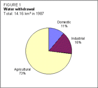 Figure 1: Water withdrawal of Democratic People's Republic of Korea. (Source: FAO-Forestry)
 The West Sea Barrage involving an 8-kilometer (km) dam across the Taedong River was completed in June 1986. It consists of a main dam, 3 locks and 36 sluices, and is believed to be the longest dam in the world. Another major dam has been built on the Yalu River.
About 60% of electricity generation is provided by hydropower, with an installed hydropower capacity in operation estimated at 5,000 megawatts (MW).
Water withdrawal
The total water withdrawal was estimated at about 14.16 km3/year in 1987, of which 73% is used for agriculture (Figure 1).
Irrigation and drainage development
Irrigation development in DPR Korea has always been a major objective in the agriculture sector. In 1976, as a way of increasing the arable land area, the authorities launched a 'nature re-making programme' with the following objectives:
- to complete the irrigation of non-paddy lands;
- to reclaim 100,000 ha of new land;
- to build 150,000-200,000 ha of terraced fields;
- to reclaim tidal land;
- to conduct work on forestation and water conservation projects.
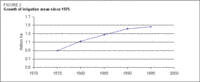 Figure 2: Growth of irrigation areas since 1975. (Source: FAO-Forestry)
 The 1987-93 plan target was to reclaim some 300,000 ha of tidal land. In 1989, a project was initiated to build a 400-km-long canal by diverting the flow of the Taedong River along the west coast. As part of the irrigation system, the canal would provide water to rural areas and newly reclaimed tidal land in South Hwanghae and South Pyongan provinces.
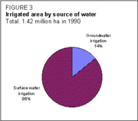 Figure 3: Irrigated area by source of water. (Source: FAO-Forestry)
 By late 1990, a total of 800 km of large and small irrigation waterways had been completed. In December 1995, the Kangryong Waterway (40 km) was the latest to be constructed. In early 1994, there were about 40,000 km of irrigation waterways together with 1,770 reservoirs and 26,000 pumping stations for irrigation purposes (Figure 2).
In 1990, about 200,000 ha were irrigated from groundwater resources (Figure 3). In 1995, the total land area under irrigation was estimated at 73% of the cultivated area (about 1.46 million ha). The irrigated land includes plains, terraced fields and tidal land. About 46% of this area consists of paddy fields.
Although no figures are available, the main irrigation technique is surface irrigation, while sprinkler and micro-irrigation were introduced on non-paddy fields in the late 1980s.
Institutional environment
At national level, the agriculture sector is directed by the Agriculture Commission. The Agriculture Commission is in charge of the planning, management and technical direction of production.
The Department of Irrigation and Drainage, within the Agricultural Commission, has the tasks of providing technical assistance to farmers and of developing irrigation techniques. At provincial level, the Agricultural Commission is represented by the Provincial Rural Economy Committee (PREC). The PREC is directly responsible for the production and management of the state farms and supervises agricultural production through District/County Cooperative Farm Management Committees (CCFMCs). The country has over 200 districts and counties where the CCFMCs are entrusted with the planning, production and management of cooperative farms. The CCFMCs also directly supervise state enterprises concerned with agricultural production (i.e., farm machinery and implement factories, tractor stations and irrigation offices).
Trends in water resources management
The Government has adopted two strategies to meet its future cereal requirements:
- to increase production by using high yielding varieties (HYVs), and through more efficient, environmentally sound soil and crop management practices;
- to increase the area of cultivated land by reclaiming tidal lands.
In view of the shortage of arable land and the loss of land through natural disasters such as those caused by the 1995 floods, DPR Korea has undertaken rehabilitation work, as data provided by the Agricultural Commission indicate (Table 1).
| Table 1. Rehabilitation works undertaken after 1995 floods | |||
|---|---|---|---|
| Facilities | Damaged | Recovered | In need of recovery |
| Reservoirs | 102 | 54 | 48 |
| Pumping stations | 2,804 | 2,711 | 93 |
| Embankments | 6,528 km | 2,569 km | 3.959 km |
| Irrigation canals (inside plots) | 1,974 km | 1,974 km | |
| Irrigation structures (dikes, flood gates, etc.) | 3,760 | 2,653 | 1,107 |
According to an Food and Agriculture Organization (FAO) report, the agriculture sector faces the following challenges and constraints:
- shortage of arable land and increasing cost of land reclamation;
- massive rise and fall of river/lake levels caused by heavy rainfalls and drought at critical points in the crop cycle.
Strategic options aiming at achieving sustainable food security by improving agricultural production systems could be based on:
- reconstructing flood-stricken areas;
- developing hilly mountainous land and reclaiming tidal land;
- modernizing irrigation systems through increased investment;
- improving anti-flood forestation.
Further Reading
- Water profile of Democratic People's Republic of Korea, Food and Agriculture Organization.
- World Factbook: North Korea, Central Intelligence Agency.
| Disclaimer: This article is taken wholly from, or contains information that was originally published by, the Food and Agriculture Organization. Topic editors and authors for the Encyclopedia of Earth may have edited its content or added new information. The use of information from the Food and Agriculture Organization should not be construed as support for or endorsement by that organization for any new information added by EoE personnel, or for any editing of the original content. |