Water profile of Liberia
Contents
- 1 Geography, Climate, and Population
- 2 Economy, Agriculture, and Food Security
- 3 Water Resources and Use
- 4 Irrigation and Drainage Development
- 5 Water Management, Policies, and Legislation Related to Water Use in Agriculture
- 6 Environment and Health
- 7 Perspectives for Agricultural Water Management
- 8 Further Reading
Geography, Climate, and Population
Liberia, located in West Africa, covers an area of 111,370 square kilometers (km2). It borders Sierra Leone to the northwest, Guinea to the north, Cote d’Ivoire to the northeast and east, and the Atlantic Ocean to the south and southwest. Its north-south extent is about 465 kilometers (km) and its Atlantic Ocean coastline is about 520 km long. The terrain comprises mostly flat to rolling coastal plains, rising to rolling plateau and low mountains in the northeast. The coastline is characterized by lagoons, mangrove swamps, and river-deposited sandbars. The country can be divided according to elevation into four main physical regions parallel to the coast: i) coastal plains up to 100 meter (m); ii) hills from 100 to 300 m; iii) plateaus from 300 to 600 m; and iv) mountainous areas above 600 m. In 2002, the cultivated area was estimated at 600,000 hectares (ha), of which arable land covers 380,000 ha, while 220,000 ha are covered by permanent crops (Table 1).
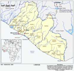 Map of Liberia. (Source: FAO)
 Liberia’s climate is tropical hot-humid. Winters are dry with hot days and cool to cold nights; summers are wet and cloudy with frequent heavy showers. The rainy season lasts from April to November and average annual rainfall is estimated at 2,391 millimeters (mm), with a spatial variation from 2,000 to 5,000 mm. Although this is much higher than the quantity of water required for crop growth, an acute water deficit is experienced anyway during a 3 to 5 month period, particularly in the uplands.
Total population in 2004 was 3.5 million, of which 52 percent were rural (Table 1). Population density was 31 inhabitants/km2.
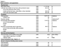 Table 1. Basic statistics and population. (Source: FAO)
 Liberia is in a post-war period facing serious political, financial, administrative, and organizational problems. Ten years of conflict have led to multiple internal displacements of hundreds of thousands of people, disrupted supply of basic social services, increased the vulnerability of women and children to extreme poverty, hunger, disease, and HIV/AIDS. Poverty is widespread.
Access to education is limited. An estimated 80 percent of schools, health service structures, water wells and sanitation facilities have been either destroyed or abandoned since 1998. No up-to-date water supply and sanitation coverage data are available, but those still functioning are in alarming and worrying conditions in almost all counties in Liberia. As a result, morbidity and mortality rates remain high and may possibly deteriorate further as [[population]s] returning to these areas are expected to increase and thereby overstretch the already either only partly functioning or malfunctioning health and social infrastructures.
Economy, Agriculture, and Food Security
Before the outbreak of civil war, agriculture accounted for about 40 percent of the gross domestic product (GDP) and Liberia had been a producer and exporter of basic products - primarily raw timber and rubber. The rubber industry generated over US$100 million export earnings annually. By the end of 1996, real GDP was as low as 10 percent of its pre-war level. However, from 1997 it increased, reflecting a post-war surge in rice, timber and rubber production, and in 2002, reached US$442 million. Nonetheless, in 2004, a still unsettled domestic security situation was slowing the process of rebuilding the social and economic structure of the country. In 2000, agriculture and forestry contributed over 90 percent of export earnings, mainly from rubber, timber, cocoa, and coffee.
Agricultural activities are still considerably reduced and food insecurity is worsening, as the areas considered to be the "food basket" of Liberia are still inaccessible. Rice production in 1995 was only 23 percent of the pre-civil war level. Cassava production has also been falling, possibly by as much as 50%. Low productivity of land and labor, shifting cultivation and low livestock production remain the main characteristics of traditional farming in Liberia. Rainfed agriculture is the predominant system. Use of water control technology is exceptional and consists mainly of unregulated manual irrigation, using watering cans.
Liberia is far from being food self-sufficient, with net cereal imports and food aid as a percent of total consumption being 44.1% for the period 1998-2000. The variation in domestic cereal production between 1992-2001 (average percent variation from mean) was 44.5%.
Water Resources and Use
Water Resources
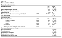 Table 2. Water sources and use. (Source: FAO)
 Liberia can be divided into two kinds of river systems:
- The major basins, which drain 97 percent of the territory in a general northeast-southwest direction. Of these, the six major rivers, originating in Sierra Leone, Guinea or in Côte d’Ivoire, are the Mano, Lofa, Saint Paul, Saint John, Cestos, and Cavalla, and together drain 65.5 percent of the country;
- The short coastal watercourses, which drain about 3 percent of the country.
Internal renewable surface water resources are estimated to be 200 cubic kilometers per year (km3/year) and internal groundwater is estimated to be 60 km3/year; all of the latter is believed to be drained by watercourses. Thus, the total internally produced renewable water resources become 200 km3/year, while an additional 32 km3/year comes from Guinea and Côte d’Ivoire, bringing the total renewable water resources to 232 km3/year. Liberia is one of the African countries with the highest amount of renewable water resources per inhabitant: more than 71,000 cubic [[meter]s] (m3/year).
Water Use
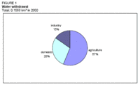 Figure 1. Water withdrawal. (Source: FAO)
 Total water withdrawal in the year 2000 was estimated at 106.8 million m3. The main water user was agriculture with 60 million m3/year (57 percent), followed by the domestic sector with 30.4 million m3/year (28 percent) and industry with 16.4 million m3/year (15 percent) (Table 2 and Figure 1).
International Water Issues
Liberia shares [[river]s] with all its neighboring countries:
- The Mano and Mugowi Rivers with Sierra Leone;
- The Makone, Lofa, Via, Nianda, and Mani Rivers with Guinea;
- The Cavalla River with Côte d’Ivoire, which forms a large part of the border between the two countries.
Irrigation and Drainage Development
Evolution of Irrigation Development
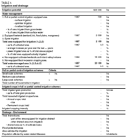 Table 3. Irrigation and drainage. (Source: FAO)
 The irrigation potential in Liberia is estimated at 600,000 ha, consisting mainly of freshwater swamps. No up-to-date information on irrigated areas in Liberia is available. In 1987, the total water managed area was 20,100 ha (Table 3 and Figure 2), comprising:
- About 100 ha equipped for full or partial control irrigation, consisting mainly of small development projects supported through international or bilateral cooperation;
- 2,000 ha of equipped wetlands and inland valley bottoms, mainly cropped with rice;
- 18,000 ha of non-equipped cultivated wetlands, swamps, and inland valley bottoms.
FAO’s Special Program for Food Security (SPFS) 2000-2002 had the following aims:
- Developing 50 ha of small swamps, complete with drainage/irrigation channels and required water control structures;
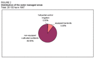 Figure 2. Distribution of the water managed areas. (Source: FAO)
 - Training of farmers and extension staff in the utilization and repair of treadle and petrol pumps;
- Training of farmers and extension staff in water control practices at field level, irrigated field maintenance and improved cultivation methods (particularly rice and vegetables);
- Demonstration of low-cost small-scale irrigation technologies on 10 ha using treadle pumps and petrol pumps, and of water management practices with the participation of farmers and extension workers.
Role of Irrigation in Agricultural Production, the Economy, and Society
The main irrigated crop is rice. It is grown in the swamps in addition to the upland rice. Shifting cultivation in the uplands is still the main technique: the secondary forest is cleared and burned, and upland rice is cropped during one or two years combined with different food crops (cassava, common groundnuts, or vegetables). Afterwards, the area returns to bush fallow for 8-10 years. This system is the preferred mode of farming in Liberia and has the advantage of maintaining the ecological system in equilibrium. However, this system cannot be applied in areas where a higher population density prevents the restoration of soil fertility due to too short a fallow period. In those areas, swamp rice is cultivated in addition to upland crops.
While in the mid-1980s about 235,000 ha of rice were cultivated, this figure dropped to 120,000 ha in 2003, leading to a decrease in total rice production from about 290,000 tonnes in the mid-1980s to 110,000 tonnes (t) in 2003. In 1995, the yield of upland rice was estimated to be 1.3 t/ha, while yields of swamp rice were about 1.6 t/ha, and yields in equipped wetlands and swamps reached more than 2 t/ha.
Gender and land tenure with regard to water management has been a well-known problem for projects in Liberia.
Water Management, Policies, and Legislation Related to Water Use in Agriculture
Institutions
The National Water Resources and Sanitation Board was created in 1981 in order to coordinate the activities of the different institutions or corporations involved in the management of water resources. Before the conflict, the main institutions involved were:
- The Liberia Water and Sewer Corporation (LWSC), in charge of the water supply systems in the urban areas;
- The Ministry of Agriculture, in charge, inter alia, of irrigation;
- The Ministry of Health and Social Affairs, in charge of sewerage;
- The Liberia Electricity Corporation, in charge of hydro-electric energy production;
- The Ministry of Rural Development in charge of water supply in rural areas;
- The Hydrology Service of the Ministry of Land, Mines, and Energy.
Environment and Health
Main environmental problems in Liberia are tropical rain forest deforestation, soil erosion, loss of biodiversity, and pollution of coastal waters from oil residue and raw sewage. Water-borne diseases such as diarrhea, dysentery, cholera, and infectious hepatitis are common.
Perspectives for Agricultural Water Management
With only about 3% or about 20,000 ha of a potential 600,000 ha of swampland cultivated with rice before the war, water control and soil management measures remain the most suitable vehicle for future development. Water deficiency in the dry season, poor drainage, flooding of lowlands and the hazard of water erosion are all problems that need to be addressed.
The development of swamp rice cultivation will become necessary with increasing population and population density. It has been estimated that with an intensification of swamp rice cultivation, it could be possible for Liberia to become self-sufficient in rice, which is the staple food crop. The urban demand for rice is also rapidly expanding.
Successful swamp rice production development in Liberia requires: i) application of improved swamp rice cultivation technologies; ii) high labor inputs, which can conflict with upland farming needs; iii) availability of modern inputs (improved cultivars, good quality seed, fertilizers); and iv) a change of mentality amongst farmers, who should consider rice as a means of increasing cash income and not just as a subsistence crop.
Further Reading
- FAO. 1986. Liberia, report of an agricultural sector review mission. Report 85/86 CP-LIR.8
- FAO. 2000a. Special report FAO/WFP crop and food supply assessment mission to Liberia.
- FAO. 2000b. Special Programme for Food Security, water control and intensification components. TCP/LIR/8923 (D) and TCP/LIR2802 (D). Project Documentation.
- Water Profile of Liberia, Food and Agriculture Organization.
- World Factbook: Liberia, Central Intelligence Agency.
| Disclaimer: This article is taken wholly from, or contains information that was originally published by, the Food and Agriculture Organization. Topic editors and authors for the Encyclopedia of Earth may have edited its content or added new information. The use of information from the Food and Agriculture Organization should not be construed as support for or endorsement by that organization for any new information added by EoE personnel, or for any editing of the original content. |