Water profile of Bhutan
Contents
Geography and population
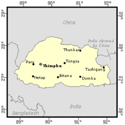
 Map of Bhutan. (Source: FAO-Forestry)
 Bhutan is a Himalayan landlocked country with a total area of 47,000 km2. For administrative purposes, it is divided into 20 dzongkhag (districts). The country is almost entirely mountainous, with flat land limited to the broader river valleys and along the foothills bordering the Indian subcontinent. Altitudes range from 7,500 meters (m) at the summit of Kula Kangri on the northern border to about 200 m at the Indian border in the south. Bhutan has three major landform features: the southern foothills, the inner Himalayas and the higher Himalayas.
Owing to the extremely rugged mountainous terrain, only 3.6% of the total area, or 169,108 hectares (ha), is cultivated, of which 17,092 ha are under permanent crops. There is little room for expansion of acreage under agricultural production.
In 1996, the total population was estimated at 1.81 million by the United Nations, although the latest official estimates give a figure of 600,000 inhabitants for 1990. About 93% of the total population is rural. The current population growth rate is estimated at 3.1%, which is one of the highest in the region. With an average of 38 inhabitants/km2, the population density is relatively modest by regional standards. However, when expressed in terms of hectares of cultivated area, the population density is one of the highest in the world. The population is unevenly distributed with the highest population densities at the lower altitudes. About 95% of the population lives in the southern subtropical zone or in the central mid-mountainous zone, mainly in the relatively gentle sloping areas of the river valleys.
The agriculture sector accounted for 38.6% of gross domestic product (GDP) in 1993. In 1996, around 94% of the labor force was engaged in the agriculture sector. In 1993, hydropower made up 8% of GDP (25% of export earnings).
Climate and water resources
Climate
Bhutan has perhaps the greatest diversity of climate of any country of its size in the world, ranging from hot and humid subtropical conditions in the south to the perpetual ice and snow of the high Himalayas.
The main climatic factor is the southwest monsoon which lasts from mid-June to September, bringing with it some 60-90% of the annual precipitation, depending upon the region. Precipitation ranges from 2,500 mm/year (even 5,000 mm/year in localized areas) in the south to 500-1,000 mm/year in the inner valleys, and to less than 500 mm/year above 4,000 m. Average precipitation is roughly estimated around 4,000 mm/year. In the dry season, rainfall is erratic and limited, and the peak demand for supplementary irrigation would be in April and May.
Nearly every valley in Bhutan has a swiftly flowing river or stream, fed either by the perennial snows, the summer monsoon or both.
River basins
Except for a small river in the extreme north of the country which flows north, all rivers flow south to India. The river basins are oriented north-south and are, from west to east, the Jadalkha, Torsa, Raidak, Sankosh, Mao Khola/Aie, Manas and eastern river basins, this last basin being composed of the Bada and Dhansiri rivers. Only the Torsa River has its primary source outside Bhutan, in India. Although it has not been measured, this inflow is negligible in comparison to the internal renewable water resources which are estimated at 95 km3/year. Because of the mountainous character of the country, the groundwater resources in Bhutan are probably limited and are drained by the surface water network. They cannot in any case be considered as an additional resource.
Lakes and dams
The only dam in the country is the Chukha hydropower dam. Some dams could be constructed in the near future for hydropower purposes. There is no wastewater treatment in Bhutan, but two wastewater collection and treatment projects are being implemented in the cities of Thimphu and Phuntsoling.
Most rivers are deeply incised into the landscape, a fact which greatly limits the possibilities for run-of-the-river irrigation. On the other hand, Bhutan has a large potential for hydropower development, which is presently estimated at an exploitable 12,000 megawatts (MW) out of a theoretical capacity of 20,000 MW. The total power generation capacity in 1994 was 344 MW, of which 325 MW from the Chukha hydropower plant. Hydroelectricity represents 96% of the country's electricity generating capacity and 99.9% of its electricity generation.
About 87% of the electricity generated within Bhutan is exported to India. A number of hydropower projects are now under construction or negotiation.
Water withdrawal
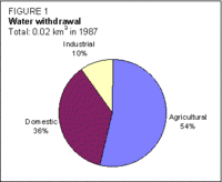
The total water withdrawal was estimated at 20 million m3 in 1987 (Figure 1), which is a minimal fraction of the resources (0.02%).
Irrigation and drainage development
 Figure 1: Water withdrawal of Bhutan. (Source: FAO-Forestry)
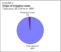
  Figure 2: Origin of irrigation water. (Source: FAO-Forestry)
 Irrigated agriculture in Bhutan can be almost equated to paddy cultivation which takes place during the summer-autumn period. Indeed, wherever irrigation water is available on arable lands below 2,600 meters, farmers have traditionally chosen to grow rice.
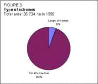
Irrigation systems in Bhutan are typically less than 100 ha in extent. Only two large-scale systems have been developed by the Government in recent years: the Taklai Irrigation scheme (1,350 ha) and the Geylegphug Lift Irrigation scheme (800 ha), though neither of them is in operation. However, the Taklai scheme is being rehabilitated and will be in operation soon. There is little possibility of further development of large schemes due to the geographical conditions. Two types of small-scale schemes can be found:
- valley bottom schemes, located on relatively gently sloping terraces beside the major rivers. Water is usually reliably provided by purely gravity fed channels from secondary rivers;
- hill schemes, located at higher elevations, on more steeply sloping land where tertiary streams and rivers are the sources of water.
It is estimated that there may be 1,500-1,800 irrigation schemes in the country. River diversion is the source of water for all Bhutanese schemes, except in the Geylegphug lift irrigation scheme (Figure 2).
 Figure 3: Types of irrigation schemes. (Source: FAO-Forestry)
 Generally, the diversion structures are not permanent, and in a large number of rehabilitated schemes part of the project consists of improving the intake structure to make it permanent.
The irrigated areas are called wetland in the local classification. This means that they have been terraced for basin irrigation. These areas were estimated at 27,020 ha by an agronomic survey, but a study based on a remote sensing approach gave a figure of at least 38,734 ha in 1995 (Figure 3).
In summer, almost all wetland is under paddy cultivation. Double cropping of paddy is limited to the lowest altitudes where the winter temperatures allow its cultivation. Where paddy cannot be cultivated, wheat, buckwheat, mustard and potato are cropped on wetland areas during the winter season. The wetland areas can be cropped during the winter season, though watering of these winter crops is generally limited to one irrigation at the time of land preparation. Table 1 lists the irrigated crops on the 27,020 ha of wetland which were known before the re-estimate.
To a limited extent, farmers have started to irrigate horticultural crops, including orchards, using hose pipes and surface irrigation methods.
| Table 1: Crops on irrigated areas | |||||
|---|---|---|---|---|---|
| Crop | Summer | Winter irrigated | Winter not irrigated | ||
| Paddy | 27,020 ha | 380 ha | --- | ||
| Maize | --- | --- | 1,600 ha | ||
| Wheat and barley | --- | 4,900 ha | |||
| Buckwheat and millet | --- | --- | 1,400 ha | ||
| Mustard | --- | --- | 400 ha | ||
| Potato | --- | 500ha | --- | ||
| Others | --- | --- | 200 ha | ||
| Total | 27,020 ha | 9,380 ha | |||
Irrigation schemes can be classified according to their origin:
- indigenous irrigation systems, which have evolved with little or no government assistance. No technical assistance has been provided, and the maximum involvement of government may have been the provision of a few bags of cement;
- assisted farmer-initiated irrigation systems, which have been constructed by the beneficiaries, but which have received technical and other government assistance on one or more occasions to restore or improve the system;
- government initiated irrigation systems, which have been constructed under the government assistance program.
All three categories of schemes are managed by farmers. The level of government assistance had, until recently, little or no bearing on the development of Water User Groups (WUGs). Government assistance for strengthening local organizations and formalizing them into Water User Associations (WUAs) started only after the adoption of the national irrigation policy in 1992.
Irrigation canals have an acute sedimentation problem. Sedimentation is generally caused by sand accumulation from subsidiary sources and runoff into irrigation canals during heavy monsoon rains. Generally, sand and silt traps are constructed and periodically flushed to alleviate this problem.
The average cost of irrigation development varies widely depending upon the region. The National Irrigation Policy states that the maximum capital investment per hectare for the main canal development should be US$630 and US$950 for renovation schemes and new schemes respectively, while it should be US$160/ha for the development of the distribution system.
As most of the schemes are terraces, no drainage network has been constructed.
Institutional environment
There is no institution specifically responsible for water resources. Because of the high hydropower potential, the Department of Power has recently been given responsibility for hydrological and meteorological data collection.
The Irrigation Agency consists of irrigation offices at three levels:
- Central level: the Irrigation Section of the Research, Extension and Irrigation Division under the Ministry of Agriculture, which is responsible for the coordination of all sector activities, including policy formulation, monitoring and evaluation;
- Regional level: the Project Facilitation Offices, which provide technical, logistic, communication and accounting support for two International Fund for Agricultural Development (IFAD)-financed projects covering three and six districts of Bhutan;
- District level: the District (Dzongkhag) Irrigation Offices, which are fully responsible for the planning and implementation of all irrigation facilities in their district.
A National Environmental Commission has received the mandate to formulate a strategy to ensure that all aspects of the utilization of natural resources and the possible pollution of the environment are taken into consideration in development policies as well as in concrete development projects.
The Land Law (1979) allows all types of agricultural land to be converted to wetland but prohibits wetland from being changed (Land-use and land-cover change) to other forms of land use. This was consistent with the Government's policy at the time, which aimed to achieve complete self-sufficiency in rice. Land is privately registered in accordance with the Land Law which sets the maximum limit a person can own at 10 hectares (ha) (except for orchard and pasture where there is no limit). All non-registered land is considered forest land, owned by the Government and subject to the Forest Act.
A national irrigation policy was adopted in 1992. It focuses mainly on the management aspects of irrigation and particularly on the importance of the strengthening local organizations and formalizing them in WUAs.
Trends in water resources management
Until the 1970s, all irrigation schemes had been constructed and maintained by the beneficiaries themselves. With the start of the Government's irrigation development program in the late 1960s and early 1970s, many schemes were built or improved with external assistance while management remained in the hands of the water users. With the new irrigation policy adopted in 1992, government assistance to the irrigation sector has been redefined, with three basic principles: meaningful farmer participation; support to WUAs; and multidisciplinary teamwork. The emphasis is on scheme renovation rather than new irrigation development, and the whole process of public intervention has been carefully and precisely elaborated in view of the three principles (11 steps from farmers' requests and preliminary investigations to monitoring through to the end of construction).
After two years of implementation, the irrigation policy has been discussed in view of the forthcoming 8th Five Year Plan (1997-2002), which states the crucial role of irrigation for rice production with a view to achieving at least 70% of self-sufficiency in all major grains by 2002, and for crop diversification and intensification with a view to increasing Bhutan's revenue base and to raising rural incomes.
Three immediate objectives have been set:
- to raise the productivity of existing rice-based irrigation schemes through sustainable improvements in water delivery and management;
- to increase rural incomes by diversifying the range of irrigated crops on wetland as well as dryland;
- to rationalize the irrigation assistance program with a view to increasing the role of water users and the private sector, and to reduce recurrent government investments in irrigation schemes.
A revision, improvement and expansion of the national irrigation policy will thus be necessary, and are planned within the framework of a proposed irrigation program strengthening project.
Further reading
- Water profile of Bhutan, Food and Agriculture Organization.
- World Factbook: Bhutan, Central Intelligence Agency.
- Asian Development Bank & Ministry of Agriculture. 1994. Technical assistance to the Kingdom of Bhutan for the irrigation action plan, main document. Report TA 1956-BHU prepared by Hunting Technical Services Ltd. in association with Mott MacDonald Ltd. Thimphu.
- FAO. 1992. Western watershed conservation and management project. Socio-economic and farming systems study. Report 89/92 ADB-BHU 5 prepared by FAO Investment Centre for the Asian Development Bank. Rome.
- Hokkaido Engineering Consultants Co. 1992. The Paro Valley agricultural development project, basic design report (Phase III). Report prepared for JICA and the Ministry of Agriculture. Thimphu.
- Irrigation Section, Ministry of Agriculture. 1990. Irrigation policy exercise, main document. Thimphu.
- Irrigation Section, Ministry of Agriculture. 1995. Role of the irrigation programme in the 8th five year plan and beyond. Discussion papers presented at the Irrigation Policy Workshop held in Paro, 7-9 December. Thimphu.
- Kinzang Wangchuk, Ministry of Agriculture. 1995. Irrigation management transfer in Bhutan. In Irrigation management transfer in Asia published by FAO/RAPA. Bangkok.
- Land Use Planning Project. 1995. Land cover figures for Bhutan, working figures. Thimphu.
- Royal Government of Bhutan. 1995. Bhutan round table meeting, Volume 1: The progress of the seventh plan. Thimphu.
- UNDP. 1993. Bhutan power system master plan. Terminal report. Project BHU/87/025. Thimphu.
- World Bank. 1983. Bhutan: development in a Himalayan kingdom. Report 4307-BHU. Washington, D.C.
- World Bank. 1994. Bhutan: country economic memorandum. Report 13495-BHU. Washington, D.C.
| Disclaimer: This article is taken wholly from, or contains information that was originally published by, the Food and Agriculture Organization. Topic editors and authors for the Encyclopedia of Earth may have edited its content or added new information. The use of information from the Food and Agriculture Organization should not be construed as support for or endorsement by that organization for any new information added by EoE personnel, or for any editing of the original content. |