Water profile of Libya
Contents
- 1 Geography, Climate, and Population
- 2 Economy, Agriculture, and Food Security
- 3 Water Resources and Use
- 4 Irrigation and Drainage Development
- 5 Water Management, Policies, and Legislation Related to Water Use in Agriculture
- 6 Environment and Health
- 7 Perspectives for Agricultural Water Management
- 8 Further Reading
Geography, Climate, and Population
The Libyan Arab Jamahiriya has a total area of about 1.76 million square kilometers (km2). It is bordered in the north by the Mediterranean Sea, in the east by Egypt and Sudan, in the south by Chad and Niger, and in the west by Algeria and Tunisia. Four physiographic regions can be distinguished:
- The Coastal Plains that run along the Libyan coast and vary in width;
- The Northern Mountains that run close to the coastal plains and include the Jabal Nafusah in the west and the Jabal al Akhdar in the east;
- The Internal Depressions that cover the center of the Libyan Arab Jamahiriya and include several oases;
- The Southern and Western Mountains.
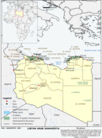 Map of Libya. (Source: FAO)
 About 95 percent of the country is desert. The cultivable area is estimated at about 2.2 million hectares (ha) which is 1.2 percent of the total area of the country. Permanent pastures account for 13.3 million ha, annual crops for 1.8 million ha and permanent crops for only 0.3 million ha (Table 1).
The climatic conditions are influenced by the Mediterranean Sea to the north and the Sahara desert to the south, resulting in an abrupt transition from one kind of weather to another. The following broad climatic divisions can be made:
- The Mediterranean coastal strip with dry summers and relatively wet winters;
- The Jabal Natusah and Jabal Akhdar highlandd experiencing a plateau climate with higher rainfall and humidity and low winter temperatures, including snow on the hills;
- Moving southwards to the interior, pre-desert and desert climatic conditions prevail, with torrid temperatures and large daily thermal variations. Rain is rare and irregular and diminishes progressively towards zero.
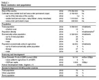 Table 1. Basic statistics and population. (Source: FAO)
 Annual rainfall is extremely low, with about 93 percent of the land surface receiving less than 100 millimeters per year (mm/year). The highest rainfall occurs in the northern Tripoli region (Jabal Nafusah and Jifarah Plain) and in the northern Benghazi region (Jabal al Akhdar), these two areas being the only ones where the average annual rainfall exceeds the minimum value (250-300 mm) considered necessary to sustain rainfed agriculture. Rainfall occurs during the winter months, but great variability is observed from place to place and from year to year. Average annual rainfall for the country as a whole is 26 mm (Table 2).
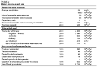 Table 2. Water: sources and use. (Source: FAO)
 Total population was about 5.7 million in 2004, including some 0.8 million non-Libyans. Of the total population only 13 percent is rural. The annual population growth rate for the period 1995-2000 was estimated at 2.2 percent. However, growth appears only in the urban areas, with the rural population showing a negative growth of 1.3 percent. The average population density of about 3 inhabitants/km2 varies between 150 inhabitants/km2 in the northern regions to less than 1 inhabitant/km2 elsewhere. In 1995, 54 percent of the Libyan population lived in the western coastal area (Jifarah plain and Misratha area). The eastern coastal area (Al Jabalal Akhbar) is the second area of population concentration with 21 percent. This means that 75 percent of the population is concentrated over 1.5 percent of the total area of the country. In 2002, 72 percent of the population had access to improved drinking water sources (72 percent of the urban population and 68 percent of the rural population). About 97 percent of the urban population and 96 percent of the rural population had access to improved sanitation services.
Economy, Agriculture, and Food Security
Total Gross Domestic Product (GDP) was US$19,100 million (current US$) in 2002, with an estimated growth rate of 3.2 percent per year. The Libyan economy depends primarily upon revenues from the oil sector, which contributes practically all export earnings and about 25 percent of GDP. The non-oil manufacturing and construction sectors, which account for about 20 percent of GDP, have expanded from processing mostly agricultural products to include the production of petrochemicals, iron, steel, and aluminum. Agriculture contributes to about 9 percent of GDP and provides employment for about 5 percent of the total economically active population. While 25 percent of the total economically active population are women, in the agricultural sector they account for 67 percent of the labor force. The unemployment rate is about 30 percent.
Given the arid nature of much of the Libyan Arab Jamahiriya, irrigated farming systems have always been of crucial importance in generating much of the country’s agricultural output. About 50 percent of the cereal production and about 90 percent of the fruit and vegetable production originates from irrigated agriculture. With very limited renewable water resources, the Libyan Arab Jamahiriya relies heavily on imports to satisfy food requirements. In 2000 the import of cereals, sugar and oil represented a contribution of 68 percent to the national calorie budget. The degree of need satisfaction and quality of diet at household or individual level varies. In the current situation, food security at national level has been achieved, but at the same time food self-sufficiency is not feasible.
Water Resources and Use
Water Resources
|
| ||
|
|
|
|
| Wadi Mejenin | 58 | 10 |
| Wadi Kaam | 111 | 13 |
| Wadi Ghan | 30 | 11 |
| Wadi Zaret | 8.6 | 4.5 |
| Wadi Lebda | 5.2 | 3.4 |
| Wadi Qattara | 135 | 12 |
| Murkus | 0.15 | 0.15 |
| Bin Jawad | 0.34 | 0.34 |
| Zaza | 2 | 0.8 |
| Derna | 1.15 | 1 |
| Abu Mansur | 22.3 | 2 |
| Wadi Tabrit | 1.6 | 0.5 |
| Wadi Dakar | 1.6 | 0.5 |
| Wadi Jarif | 2.4 | 0.3 |
| Wadi Zahawuiyah | 2.8 | 0.7 |
| Wadi Zabid | 2.6 | 0.5 |
| Total | 384.74 | 60.69 |
Total mean annual runoff calculated or measured at the entrance of the wadis in the plains (or spreading zones) is roughly estimated at 200 million cubic meters (m3/year), but a large part of it evaporates or recharges the underlying aquifers. Therefore, the regular renewable surface water resources are estimated at 100 million m3/year. Currently there are 16 dams in operation with a crest higher than 10 meters (m). No new dams are under construction, but rehabilitation of the Wadi Qattara main dam and reconstruction of the secondary dam have just been started. A number of new dams are planned, but construction has not yet begun as a result of financial restraints. The total storage capacity of these dams is 385 million m3 with an average annual storage capacity of about 61 million m3 (Table 3).
The total average annual design storage does not necessarily correspond to an additional water resource. As an example, the actual flow records (1982-1991) of Wadi Ghan indicate an average storage of only 3.99 million m3/year, as opposed to the design figure of 11 million m3/year. Moreover, certain dams have been damaged and are not in a position to store the amount of water they were designed for (Wadi Qattara). It is estimated that the real average water resource made up by the existing dams does not exceed 30 to 40 million m3/year.
Currently, aquifers are recharged only in the northern regions: Jabal Nafusah and Jifarah Plain in the northwestern zone and Jabal al Akhdar in the northeastern zone. Renewable groundwater resources are estimated at 500 million m3/year. South of 29°C North latitude, an important development of Palaeozoic and Mesozoic continental sandstone enabled water to be stored safely during the long period of the late Quaternary, before the climate turned extremely arid. Most water used in the Libyan Arab Jamahiriya comes from these huge fossil reserves. The main characteristics of groundwater occurrence in four systems which are relatively independent from each other are as follows:
- The Western Aquifer system including three interconnected sub-systems:
- The Murzuq basin;
- The Jabal Hasawnah, which is going to play an important role in the future as a water source for the western water transport system;
- The Al Hamadah al Hamra system including the Jabal Nafusah Suf-Ajjin-Tawurgha sub-basin, the Ghadamis sub-basin and the Al Hamadah al Hamra system.
- The Jifarah Plain system.
- The As Sarir Al Kufrah basin system.
- The Al Jabal al Akhdar system.
There have been several attempts during the last 25 years to introduce and expand sea water desalination plants and wastewater treatment facilities. A number of desalination plants of different sizes have been built near large municipal centers and industrial complexes. However, so far restrictions have been imposed by the high cost of energy and spare parts. The contribution of the existing desalination plants is almost negligible and exclusively used for domestic and industrial purposes. The existing operating capacity of installed plants is about 65 million m3/year, but the total water produced is only between 20 and 30 million m3/year since most of the desalinization plants are not in good operating condition. The present level of wastewater treatment is estimated at about 40 million m3/year. All treated wastewater is used for agricultural purposes.
Water Use
|
| ||||||
|
|
Water abstraction in million m3/year | |||||
| 1975 | 1980 | 1985 | 1990 | 1995 | 2000 | |
| Al Jabal Akhdar | 134 | 205 | 255 | 339 | 290 | 334 |
| Al Kufrah - As Sarir | 224 | 295 | 487 | 526 | 560 | 575 |
| Jifarah | 567 | 600 | 780 | 860 | 1,070 | 1,060 |
| Hamada el Hamra | 132 | 299 | 418 | 431 | 417 | 405 |
| Murzuq | 430 | 1,055 | 1,181 | 1,306 | 1,519 | 1,754 |
| Jabal Hasawna | 0 | 0 | 0 | 0 | 0 | 140 |
| Total | 1,487 | 2,454 | 3,120 | 3,462 | 3,855 | 4,268 |
Table 4 presents the groundwater abstraction per area during the period 1975-2000. The total abstraction of 4,200 million m3/year is about 8 times the annual renewable groundwater resources and therefore the Libyan Arab Jamahiriya depends heavily on fossil groundwater. The coastal aquifers are the only ones that are being recharged by rainfall but uncontrolled groundwater development from these aquifers exceeds the annual replenishment. This has caused a severe water level decline and seawater encroachment, which makes the coastal groundwater resources almost unusable because of their high salinity.
|
| |||||||
|
|
|
|
Agriculture |
| |||
| Transport from GMRP | Local production | Agricultural projects | Private agriculture | Total | |||
| Al Jabal al Akhdar | 0 | 127 | 0 | 207 | 207 | 334 | |
| Al Kufrah - As Sarir | 94 | 12 | 117 | 204 | 148 | 352 | 575 |
| Jifarah | 0 | 140 | 0 | 920 | 920 | 1,060 | |
| Hamada el Hamra | 0 | 36 | 209 | 160 | 369 | 405 | |
| Murzuq | 0 | 58 | 0 | 271 | 1,425 | 1,696 | 1,754 |
| Jabal Hasawna | 140 | 0 | 140 | ||||
| Total | 234 | 373 | 117 | 684 | 2,860 | 3,544 | 4,268 |
This situation has accelerated the process of water transfer through the implementation of "The Great Manmade River Project" (GMRP), which is designed to transport eventually 2,300 million m3 of fossil water from the Libyan South, where a huge amount of fossil groundwater has been stored since the late Quaternary, to the North, where the water is urgently needed. The project is ongoing and consists of five phases, of which Phase I and II are currently being implemented. For Phase I, two well fields in the As Sarir - Al Kufrah Basin have been designed to convey 730 million m3 of water per year to the coastal areas extending from Binghazi to Sirt. The first well field is located in the Sarir area and produces currently 94 million m3 of water, which is 25-30 percent of its capacity. The second well field is located near the village of Tazirbu, some 200 kilometers (km) south of the Sarir well field, and is under construction. Phase II consists of several well fields in the Jabal Hasawna area, designed to transport some 910 million m3 of water per year to the Jifarah plain around Tripoli. The first wells are now in operation and produce about 140 million m3 of water per year. The GMRP is designed mainly to serve irrigated agriculture, but until now the water has been used almost exclusively for domestic and industrial use in the major cities of the country.
Of the total water withdrawal of 4,268 million m3, about 83 percent is used for agricultural purposes, 14 percent for domestic use and 3 percent for industrial use (Table 2, Table 5 and Figure 1). More than 30 percent of the present domestic water demand is supplied by the GMRP. Most of the industrial water is used for the oil industry (injection, processing and some domestic use).
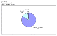 Figure 1. Water withdrawal. (Source: FAO)
 According to the assumptions made about water productivity in agriculture, the total water requirement to support basic food self-sufficiency and to meet the domestic water demand of the 12 million Libyans in the year 2025 is estimated to range between 10.5 and 16.4 cubic kilometers per year (km3/year), compared to 4.3 km3/year at present. When the GMRP is fully operational, the total amount of water available for all uses, assuming that the present groundwater production equipment will be maintained until 2025, will be in the order of 6.5 km3/year and will thus barely cover 50 percent of the total water requirement.
Irrigation and Drainage Development
Evolution of Irrigation Development
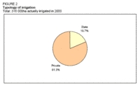 Figure 2. Typology of irrigation. (Source: FAO)
 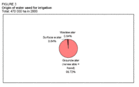 Figure 3. Origin of water used for irrigation. (Source: FAO)
 Irrigation potential has been estimated at 750,000 ha. However, the development of this potential would have to rely mainly on the use of fossil water. Considering renewable water resources, it is estimated that a maximum of 40,000 ha could be irrigated in the coastal areas.
There are three different categories of farming in the irrigation sub-sector (Figure 2):
- Private irrigation, generally on 1-5 ha plots, which receives substantial state support for water equipment, energy, and agricultural inputs. This type of farming is mostly concentrated in the traditional development areas, i.e. the Jifarah Plain, the Jabal al Akhdar, and the Murzuq Basin, and the actually irrigated area covered about 257,000 ha in 2000.
- Large-scale state farming, mainly located in the southern areas, where new irrigation schemes have been set up based on highly productive deep wells supplying water to blocks divided into small plots and cultivated by small-scale farmers.
- Large-scale state farming, mainly located in the desert areas (usually pivot systems), operated by state technicians and workers.
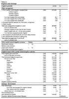 Table 6. Irrigation and drainage. (Source: FAO)
 The total water managed area is approximately 470,000 ha, all equipped for full or partial control irrigation (Table 6). On almost the entire area sprinkler irrigation is practiced, because of the sandy soils prevailing in most areas of the Libyan Arab Jamahiriya. The costs of installing sprinkler irrigation on a farm amount to about US$10,000/ha. It was estimated that of the total area of 470,000 ha, 316,000 ha was actually irrigated in 2000 (Table 7). About 99 percent is irrigated using groundwater, while the remaining 1 percent is irrigated by treated wastewater and surface water (Table 6 and Figure 3).
Because of the importance of private irrigation, representing some 81 percent of the net irrigated area in the Libyan Arab Jamahiriya, the figure of 316,000 ha should be considered a rough estimate, probably underestimated. With a cropping intensity that varies from 1.3 to 1.5 according to the area, the total harvested irrigated area (winter + summer irrigation) is estimated to range from 440,000 to 500,000 ha.
|
| ||||
|
|
|
| ||
| State schemes | Private irrigation | Total | ||
| Al Jabar al Akhdar | 0 | 24,000 | 24,000 | 100.0 |
| Al Kufrah - As Sarir | 18,500 | 8,500 | 27,000 | 31.5 |
| Jifarah | 0 | 142,000 | 142,000 | 100.0 |
| Hamada el Hamra | 22,000 | 15,000 | 37,000 | 40.5 |
| Murzuq | 18,500 | 67,500 | 86,000 | 78.5 |
| Total | 59,000 | 257,000 | 316,000 | 81,3 |
Role of Irrigation in Agricultural Production, the Economy, and Society
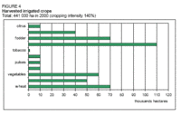 Figure 4. Harvested irrigated crops. (Source: FAO)
 Yields from rainfed as well as irrigated agriculture are generally low. Apart from the aridity of the climate which reduces rainfed yields, this is due to prevailing shallow, coarse soils with limited natural fertility and high erosion risks. The average yield of irrigated wheat and barley is much lower than the yields obtained in other Mediterranean countries. The yields for irrigated fruits, vegetables, and oil crops are generally also lower than in the surrounding countries but for these crops the differences are smaller. Apart from the crops mentioned in the Table 8, it is known that large areas of fodder (mainly berseem) are cultivated and irrigated in the winter.
It is estimated that at least 80 percent of agricultural production depends on irrigated agriculture. There are no statistics of cropped areas subdivided by rainfed or irrigated agriculture but a rough estimate of harvested crops under irrigation is given in Table 6 and Figure 4.
|
| ||
|
|
Yield in kg/ha | |
| rainfed | irrigation | |
| Wheat | 650 | 1,400 |
| Barley | 450 | 750 |
| Millet | 1,200 | - |
| Dates | 2,800 | 8,600 |
| Potatoes | - | 7,300 |
| Pulses | 600 | 1,500 |
| Citrus | - | 10,500 |
| Apples | 8,300 | 20,000 |
| Grapes | 2,300 | 10,400 |
| Vegetables | 6,700 | 13,000 |
| Olives | 700 | 2,200 |
| Groundnuts | - | 1,800 |
Food security is felt as a moral imperative for the Libyan leaders and huge efforts were made in the 1970s and 1980s to develop irrigated agriculture based on local water resources, and in the 1990s to create the conditions for the rehabilitation and development of the coastal agriculture through water transport from the south to the north. However, food security is distinctly different from food self sufficiency which is now impossible and will be more and more difficult to achieve in the Libyan Arab Jamahiriya. A debated question is whether irrigation, mostly the one based on costly water transfer, remains justified in a situation of water scarcity where the only source of water is non-renewable groundwater and where economic returns from other sectors (oil industry) would allow an easy access to the international food market.
Status and Evolution of Drainage Systems
In the Libyan Arab Jamahiriya, only about 2 percent of the irrigated land is estimated to be equipped with some form of drainage. This is mainly due to the lack of experience in the concept of drainage and the high cost of drainage installation. Moreover, most of the area under irrigation has sprinkler irrigation. The installation costs of sub-surface drainage systems are several times higher than the average international installation costs.
Water Management, Policies, and Legislation Related to Water Use in Agriculture
The responsibility for all water resources assessment and monitoring rests with the General Water Authority (GWA) which was established in 1972. The GWA is composed of six General Directorates: Planning, Follow-up and Statistics, Water Resources, Dams, Irrigation and Drainage, Soils, and Finance and Administration. It is concerned with the supervision of irrigation and drainage projects. Furthermore, it performs research and studies aimed at improving the irrigation network and it organizes on-the-job training programs for its staff. It has a documentation center and has recently established a system for data storage and retrieval linked to GIS. It also has a central laboratory equipped for various analyses related to water and soils.
The Secretariat of Agriculture and Animal Wealth is responsible for the development of irrigated agriculture and the implementation of major projects. A special Authority, called "The Great Manmade River Water Utilization Authority", is responsible for the use for agricultural purposes of the water transported from the desert to the coast. The Secretariat of Municipalities takes care of the water supply to urban settlements. At present, no water fees are imposed on users of water for irrigation purposes.
Environment and Health
In the last decade private agriculture developed rapidly. Especially along the coast this led to uncontrolled development of the coastal aquifers exceeding the annual replenishment. This caused a severe water level decline and seawater encroachment, making the coastal groundwater resources almost unusable because of their high salinity. Currently, groundwater abstraction from private farms corresponds to 47 percent of the total abstraction and is the main sector of water use, but it almost completely lacks a water resources monitoring system.
An inadequate sanitation system in the urban agglomerations (mostly in Jabal Akhdar but also around most of the cities of the south) leads to severe pollution of the shallow aquifers around the cities. Important water abstraction, either for local agricultural projects or for water transport to the coast, will cause a significant water level decline in the aquifer, due to the non-renewable character of the water sources. This will slowly induce the disappearance of natural vegetation which is still important in the Wadi ash Shati or Ghadamis oases.
Improper irrigation and drainage practices have resulted in substantial degradation of soil in the southwestern part of the Libyan Arab Jamahiriya. The planned use of transport water for irrigation along the coast of Sirt where brackish aquifers exist at a shallow depth may also result in waterlogging and salinity problems if appropriate irrigation and drainage techniques are not applied.
Perspectives for Agricultural Water Management
Irrigation development in the Libyan Arab Jamahiriya is linked to the implementation of the project to transport fossil water from the aquifer below the desert. Through the GMRP, consisting of five phases, the total volume of water to be transferred and redistributed within the country will amount to about 2 km3/year for a period of at least 50 years:
- Phase 1, completed recently, is expected to supply the north-central and northeastern zones extending from Benghazi to Sirt with a total of 700 million m3/year at a continuous flow rate of 2.0 million m3/day. Water will be produced by two well fields, Sarir and Tazirbu.
- Phase 2, under construction, will deliver 800 million m3/year at a rate of 2.5 million m3/day to the northwestern part of the country (Jifarah Plain) from more than 500 wells, distributed in several well fields located in the northern and north-eastern part of the Murzuq basin.
- Phase 3 will add about 500 million m3/year to Phase 1 at a rate of 1.6 million m3/day from an additional well field within the Kufra basin.
- Phases 4 and 5 will not involve any additional water production. Instead, the conveyance lines of Phase 1 will be extended farther to the east to reach Tobruk, and farther to the west to link with the Phase 2 pipelines.
Part of the water transported will be used for the water supply of the major cities on the coast: Tripoli, Benghazi, Sirt, and Misratah. The urban water demand is growing rapidly and will need to be met increasingly by the transfer of water from irrigated agriculture to domestic use. This is clearly the case in the Jifarah Plain (including Jabal Nafusah) where the domestic water demand in the year 2025 will be in the order of 2 million m3/day, which is almost the whole amount of the planned water transport from Jabal Hasawna. This means that the planned use of the GMRP water for agriculture will have to be progressively but drastically reduced, even when taking into account a further increase in reuse of wastewater. The only way to prevent this from happening would be through expanding the use of desalination technology.
Further Reading
- International Small Hydro Atlas.
- Kershman, S.A. 2000. 25 years of experience in operating thermal desalination plants. In: Desalination 136 (2001) 141-145.
- Pallas, P. 1980. Water resources of the Socialist People’s Libyan Arab Jamahiriya. In: The Geology of Libya. Proceedings of the Second Symposium on the Geology of Libya. Academic Press, London.
- Saad A. Alghariani. 1993. Satisfying future water demands of northern Libya.
- Salem, O.M. 1992. The Great Manmade River project. In: Water Resources Development, 8(4).
- Water Profile of Libya, Food and Agriculture Organization.
- World Factbook: Libya, Central Intelligence Agency.
| Disclaimer: This article is taken wholly from, or contains information that was originally published by, the Food and Agriculture Organization. Topic editors and authors for the Encyclopedia of Earth may have edited its content or added new information. The use of information from the Food and Agriculture Organization should not be construed as support for or endorsement by that organization for any new information added by EoE personnel, or for any editing of the original content. |
