Victoria Falls National Park, Zimbabwe
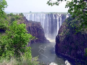
Victoria Falls on the Zambezi River. @ C.Michael Hogan
The Victoria Falls National Park (17°58'S, 25°55'E) is a World Heritage Site in Zimbabwe.
Contents
- 1 Geographical location
- 2 Date and history of establishment
- 3 Area
- 4 Land tenure
- 5 Altitude
- 6 Physical features
- 7 Climate
- 8 Vegetation
- 9 Fauna
- 10 Local human population
- 11 Visitors and visitor facilities
- 12 Scientific research and facilities
- 13 Conservation value
- 14 Conservation management
- 15 IUCN management category
- 16 Further reading
Geographical location
In the extreme west of Matabeleland North Province (Hwange District), on the southern bank of the Zambezi River, which forms the border with Zambia. The park is bounded by the river, by the Hwange Communal Area to the south (separated by a game fence), and by the road and railway to the west. 17°58'S, 25°55'E
Date and history of establishment
The Victoria Falls Special Area was proclaimed under Government Notice 318 in 1937. Victoria Falls was proclaimed a National Monument in 1935, and in 1937 the Victoria Falls Reserve (an area extending some five miles from the falls) came under the control of the Historic Monument Commission. This reserve was combined with the Victoria Falls Game Reserve to form the Victoria Falls National Park by Proclamation 25 of 1952. The area was subdivided in 1979 to form the contiguous Victoria Falls and Zambezi National Parks. National Monument status was proclaimed in terms of the Monuments and Relics Act by Government Notice 640 of 1970.
Victoria Falls National Park, together with Mosi-Oa-Tunya National Park, were inscribed on the World Heritage List in 1989.
 Mosi-oa-tunya / Victoria Falls, Zambia (Source: Embassy Lusaka Special Self-Help Coordinator Natalie Messelt 2003)
 Area
1,900 hectares (ha). The World Heritage site covers 6,860 ha. Contiguous to Zambezi National park (56,200 ha) through a narrow riparian strip, and the Matetsi-Kazuma Pan-Hwange (Wankie) complex, forming a total contiguous conservation area in Zimbabwe of over 1,846,700 ha excluding forest reserves, and to the Mosi-Oa-Tunya National Park (6,880 ha) in Zambia.
Land tenure
Government (the last private lands were acquired in 1972).
Altitude
915 meters (m) (at the top of the falls).
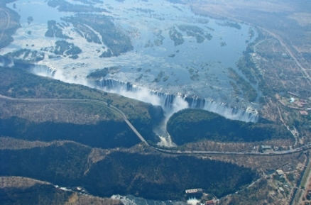
Physical features
The park contains the western half of the Victoria Falls, and the Zambezi River for several kilometers (km) below the falls. The falls are the most significant feature of the park, and when the Zambezi is in full flood (usually February or March) the falls form the largest curtain of falling water in the world (hence the African name 'Mosi-Oa-Tunya' - the smoke that thunders). During these months, over 500 million liters or water per minute go over the falls, which are 1,708 m wide, and drop 99 m at Rainbow falls in Zambia. At low water in November flow can be reduced to around 10 million litres/minute, and the river is divided into a series of braided channels that descend in many separate falls.
Below the falls the river enters a narrow series of gorges which represent locations successively occupied by the falls earlier in their history. Since the uplifting of the Makgadikgadi Pan area some two million years ago, the Zambezi River has been cutting through the basalt, exploiting weak fissures, and forming a series of retreating gorges. Seven previous waterfalls occupied the seven gorges below the present falls, and the Devil's Cataract in Zimbabwe is the starting point for cutting back to a new waterfall that will eventually leave the present lip high above the river in the gorge below.
Climate
Annual rainfall is 600-700 millimeters (mm), but the spray thrown up by the falls is partly responsible for sustaining the rain forest opposite the falls. Mean annual temperature is 20°C (14°C in June, 25°C in October).
Vegetation
Dominant types are riverine communities associated with the upper Zambezi River, the Victoria Falls rainforest and open grassland which constitutes a type locality for several species. Scrub on the shallow basaltic soils adjacent to the gorges gives way to Kalahari woodland on the deeper aeolian sands. The riverine 'rainforest' within the waterfall splash zone is of particular interest, a fragile ecosystem of discontiuous forest on sandy alluvium, dependent upon maintenance of abundant water and high humidity resulting from the spray plume. Tree species within this forest include Acacia nigrescens, Afzelia quanzensis, ebony Diospyros mespiliformis, ivory palm Hyphaene venticosa, muchiningi Mimusops zeyheri, African olive Olea africana, date palm Phoenix reclinata, waterbroom Syzygium guineense barotsense, muskili Trichilia emetica, and Cape and strangler figs Ficus spp. Herbaceous species include Sebaea pentandra, Lobelia kirkii and Gladiolus unguiculatus, while amongst the dense fern growth is found Cheilanthes farinosa.
Fauna
 Heuglin's Robin (Source: University of Maryland)
 A number of large mammals are seen here, all of which occur in the Zambezi National Park. The rich avifauna (400 species in the Victoria Falls region as a whole) includes a wide range of waterbirds along the river above the falls, and birds such as Heuglin's robin Cossypha heuglini, Knysna turaco Tauraco corythaix, and trumpeter hornbill Bycanistes bucinator in the falls 'rainforest' area. The Taita falcon Falco fasciinucha (scarce but widespread in eastern and central Africa) breeds in the gorges, as do black stork Ciconia nigra, black eagle Aquilla verreauxi, peregrine falcon Falco peregrinus and augur buzzard Buteo rufofuscatus augur. Victoria Falls forms a geographical barrier between the distinct fish faunas of the upper and middle Zambezi River, with fish species including breams Oreochromis mossambica, T. macrochir, T. andersoni, Serranochromis robustus, Sargochromis condringtoni, chessa Distichodus schenga, tigerfish Hydrocynus vittatus, and barbel Clarias gariepinus.
Local human population
Ethnic composition of the people living in the falls area outside the parks is a mixture of recent immigrants and long-term occupants. The Tonga people have been living in the area for at least seven centuries, latterly with Subiya, Leya, Toka and Totela (and with smaller numbers of Nanzwa, Yeyi and Mbukushu). More recent immigrants included Lozi, Kololo, Ndebele and English language speakers.
Visitors and visitor facilities
These are well developed with hotels available in Victoria Falls town, which is readily accessible by road, rail or air. There are good paths to the Falls and through the 'rainforest', including a walk with steps cut into the cliff, which descends to a viewing platform a third of the way down into the gorge.
Scientific research and facilities
Research is carried out by local Parks and Wild Life Department scientists on protection of all riparian vegetation including the '{C}{C}{C}rainforest'. Basic plant and animal monitoring programs are carried out. The park is part of the Zambezi-Matetsi complex for research purposes, with laboratories at Isidumuka, 89 km south of Victoria Falls.
Conservation value
The Mosi-Oa-Tunya/Victoria Falls National Park is one of the world's most spectacular waterfalls. The falls and associated gorges are an outstanding example of river capture and the erosive forces of the water still continues to sculpture the hard basalts.
Conservation management
The park is managed in accordance with the national parks policy and regulations, there is a specific policy document for the Victoria Falls-Matetsi complex. Killing, disturbance or removal of or damage to wildlife is prohibited (although fishing without license is allowed), and livestock and domestic animals are excluded. The park is divided into two Wild Areas separated by the road and railway linking Zambia and Zimbabwe across the Victoria Falls Bridge. Access is currently unlimited. Large mammals are being encouraged in the Gorges Wild Area while ensuring that any increase does not adversely affect the perennial vegetation. Development has been confined to paved or gravel paths, entrance gates, and limited interpretative displays.
Management constraints
Victoria Falls town lies next to the park and is a major visitor destination. The town and intense visitor throughput caused drainage and erosion problems, now successfully rehabilitated at considerable cost. The road, railway and low-flying aircraft cause some adverse auditory and visual impacts, although the road and railway are largely outside the park boundary except where the road and rail links between Zambia and Zimbabwe bisect the park, and then cross the river in a spectacular bridge over the second gorge (Falls Bridge). The 'rainforest' is vulnerable to disturbance by trampling, which allows penetration by ruderal species such as Lantana camara.
Staff
Administered by a ranger with a complement of scouts and general workers under the direction of the Warden, Victoria Falls (undated information).
Budget
No information.
IUCN management category
- III (Natural Monument)
- Natural World Heritage Site - Criteria ii, iii
Further reading
There is an extensive literature covers the archaeology, history, geology, fauna and flora of Victoria Falls and environs with more specific reports and papers dealing with planning development, the management of the biological resources, and reclamation of the Falls rain forest area.
- Newman, M. (1987). Victoria Falls: a visitor's guide to the Victoria Falls. Victoria Falls Publicity Association, Victoria Falls.
- Phillipson, D.W. (Ed.) (1975). Mosi-oa-Tunya. A handbook to the Victoria Falls Region. Longman. ISBN: 0582641675.
- Zambia/Zimbabwe (1988). Nomination of Victoria Falls/Mosi-Oa-Tunya as a WorldHeritage Site. Ministry of Tourism, Zambia, and Ministry of Natural Resources and Tourism, Zimbabwe.
| Disclaimer: This article is taken wholly from, or contains information that was originally published by, the United Nations Environment Programme-World Conservation Monitoring Centre (UNEP-WCMC). Topic editors and authors for the Encyclopedia of Earth may have edited its content or added new information. The use of information from the United Nations Environment Programme-World Conservation Monitoring Centre (UNEP-WCMC) should not be construed as support for or endorsement by that organization for any new information added by EoE personnel, or for any editing of the original content. |
1 Comment
Peter Howard wrote: 02-02-2011 19:43:24
Readers may want to visit the African Natural Heritage website to view a selection of images and map of the Readers may want to visit the African Natural Heritage website to view a selection of images and map of the Victoria Falls National Park world heritage site, and follow links to Google Earth and other relevant web resources: http://www.africannaturalheritage.org/Victoria-Falls-Zimbabwe-and-Zambia.html