US Forest Service wildflower map
US Forest Service wildflower map
US Forest Service releases
updated wildflower map
Hundreds of national forest locations in the USA are listed as viewing areas
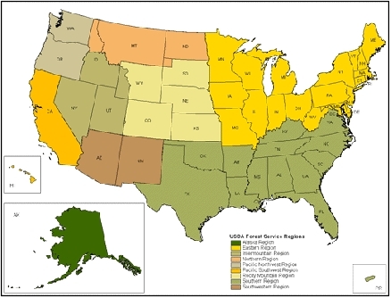
The U.S. Forest Service has released an updated online wildflower map with hundreds of locations on national forests for prime wildflower viewing, making it easier than ever to enjoy the USA’s great outdoors. The wildflower map includes 317 wildflower viewing areas on National Forest System lands and can be referenced by specific states, individual national forests and geographic regions.
“This updated map provides visitors a quick guide to find locations and best viewing times for the spectacular natural beauty of wildflowers on national forests,” said Forest Service Chief Tom Tidwell. “This is one more way folks can experience the bounty of natural surroundings.”
For many rural communities, the tourist revenue generated by thousands of wildflower festivals and events held each year helps support local economies. According to recent research, viewing and photographing wildflowers and trees is the fastest growing nature-based outdoor activity.
A narrative for each location describes the viewing area’s botanical habitat, the types of wildflowers that can be found by season, and recommendations for the best time of year to visit. Information on safety advisories such as animal habitats, clothing recommendations, insect or plant cautions, and traffic and parking tips are included. Directions to the site, the closest town and contacts for more information are also offered.
The map is part of the agency’s Celebrating Wildflowers web site which includes more than 10,000 plant images and information about the aesthetic, recreational, biological, medicinal, and economic values of native plants. Feature sections focus on the role of pollinators, overviews of flower types, and spotlights on rare and interesting plant communities. An ethnobotany page highlights how people of particular cultures and regions make use of indigenous plants. Educational activities for kids and resources for teachers also are available.
The mission of the U.S. Forest Service is to sustain the health, diversity, and productivity of the nation's forests and grasslands to meet the needs of present and future generations. Recreational activities on our lands contribute $14.5 billion annually to the U.S. economy. The agency manages 193 million acres of public land, provides assistance to state and private landowners, and maintains the largest forestry research organization in the world.
USDA works with state, local and Tribal governments and private landowners to conserve and protect our nation’s natural resources – helping preserve our land, and clean our air and water. President Obama launched the America’s Great Outdoors initiative in 2010 to foster a 21st century approach to conservation that is designed by and accomplished in partnership with the American people. During the past two years, USDA’s conservation agencies— the U.S. Forest Service, the Natural Resources Conservation Service, and the Farm Service Agency—have delivered technical assistance and implemented restoration practices on public and private lands. We are working to better target conservation investments: embracing locally driven conservation and entering partnerships that focus on large, landscape-scale conservation.
April 2, 2012
Contact:
- Press Office: (202) 205-1134
