Tundra ecoregion (CEC)
| Topics: |
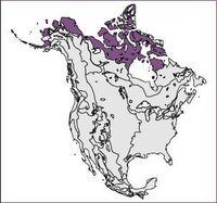
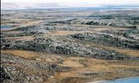
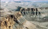
This is the largest Arctic Level I ecological region (Tundra ecoregion (CEC)) on the continent. It covers northern Alaska, Yukon, the Arctic islands of Canada, portions of the mainland of the Northwest Territories, and northern Québec. The region has a reputation of being a desolate, cold, dry and desert-like setting but in reality, the landscape is diverse, ranging from vast grassland-like plains to stark, bold mesas; from ice covered lakes to snow-free uplands; and the climate ranges from long, dark, cold winters to short, cool summers with long periods of daylight (Solar radiation). Spring and summer bring a sudden greening of the landscape. This ecological region is sparsely populated with 26,000 people. Major activities include hunting, fishing and trapping.
Physical Setting
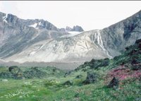
The Arctic islands circumscribe a variety of oceanic conditions. In the far north, the waters are icefast, even through the summer periods. Towards the south, open waters are more common in the summer, but pack ice usually persists offshore. The permafrost is continuous and may extend to depths of several hundred meters. Mostly underlain by Precambrian granitic bedrock with some areas of flat-lying Palaeozoic and Mesozoic sedimentary bedrock, the terrain consists largely of broadly rolling uplands and lowlands. Much of it is mantled by discontinuous shallow and deep morainal deposits, except near the coasts, where fine-textured marine sediments occur. Strung out across the landscape are long, sinuous eskers, reaching lengths of 100 kilometers (km) in places. The undulating landscape is studded with innumerable lakes and wetlands in the Canadian Shield section of the ecological region. Soils are frozen, with a shallow and wet thaw layer in the summer.
This region experiences long, cold winters and short, cool summers. Mean annual temperature ranges from –17°C in the northern islands to –7°C in northern Quebec. Summer mean temperatures range from –1.5°C in the north to 6°C in the south, producing a short growing season. The short summer growing season is enhanced by long periods of daylight (Solar radiation). Winters pass in darkness. The mean winter temperature ranges from –31°C in the north to –17.5°C in northern Quebec. The annual precipitation varies from 100 millimeters (mm) to 500 mm, the lowest in Canada. Snow may fall any month of the year and usually persists on the ground for at least 10 months (September to June).
Biological Setting
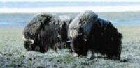
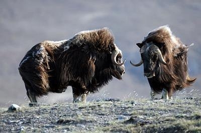
This ecological region represents a major area of transition between the Taiga (North American taiga) forest to the south and the treeless Arctic tundra to the north. It is characterized by dwarf shrubs that decrease in size moving north, with very low and flattened plants being most characteristic of the northern and central locales. Major river valleys support scattered clumps of stunted spruce trees. Typical shrubs include dwarf birch, willows, and heath species commonly mixed with various herbs and lichens. Wetlands are common in the low-lying areas, mainly supporting sedge and moss covers. A wide variety of mammals thrive in this ecological region. The region includes the major summer range and calving grounds for Canada’s largest caribou herds, the barren ground caribou in the west and the woodland caribou in the east. The Peary caribou are found only in the high Arctic islands. Other mammals include grizzly bear, musk ox, Arctic fox, Arctic hare, polar bear, wolf, moose, Arctic ground squirrel and lemming. The area is also a major breeding and nesting ground for a variety of migratory birds. Representative species include snow, Brant and Canada goose; yellow-billed, Arctic, and red-throated loons; whistling swans; oldsquaw ducks; gyrfalcons; willow and rock ptarmigan; red-necked phalarope; parasitic jaeger; snowy owls; hoary redpoll and snow bunting. In the adjacent marine environment, typical species include walrus,[seal, beluga whale and narwhal. In the summer months, California gray whales migrate here to feed.
Human Activities

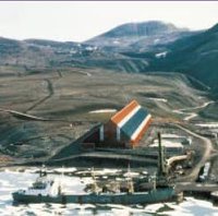
Hunting, trapping and fishing remain important activities in the local economy. Some areas targeted for hydrocarbon development and several mining enterprises are active. Construction and some tourism, as well as the management and delivery of government services, are the other principal activities. Inuit form about 80 percent of the sparse population of 26,000. Iqualiut on Baffin Island is the largest center, with a population of 3,600. Other major centers include Baker Lake, Cambridge Bay, Pangnirtung, Tuktoyaktuk, Rankin Inlet and Coppermine.
| Disclaimer: This article is taken wholly from, or contains information that was originally published by, the Commission for Environmental Cooperation. Topic editors and authors for the Encyclopedia of Earth may have edited its content or added new information. The use of information from the Commission for Environmental Cooperation should not be construed as support for or endorsement by that organization for any new information added by EoE personnel, or for any editing of the original content. |