Tulare Basin (Bailey)
Contents
Lithology and Stratigraphy
This subsection contains Quaternary lacustrine sediments. They are fine-grained deposits derived from both the southern Sierra Nevada and the southern Coast Ranges.
Geomorphology
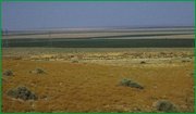
This subsection is on a level lake basin. It is covered by water in wet years, but it was covered by a permanent lake before tributary water was diverted for irrigation. The subsection elevation range is from 180 to about 200 feet. Lacustrine processes have dominated in the past, but fluvial and eolian processes are now important.
Soils
The soils are mostly Vertic Haplaquolls, but also Sodic Endoaquerts, Typic Endoaquepts, and Fluvaquentic Endoaquolls. The soils are poorly drained. Shrink and swell upon drying and wetting and upward movement of soluble salts are the most evident pedogenic processes. Soil temperature regimes are thermic, and soil moisture regimes are aquic.
Vegetation
The predominant natural plant community are Emergent aquatic communities and Saltgrass series.
Characteristic series by lifeform include:
Climate
The mean annual precipitation is about 6 to 7 inches; it is all rain. Mean annual temperature is about 60° to 62° F. The mean freeze-free period is about 250 to 275 days.
Surface Water
This subsection is a basin that is a sink for water from the southern ends of the Sierra Nevada and the Coast Ranges. It is covered by water in wet years, but it was covered by a permanent lake before tributary water was diverted for irrigation.