Tristan da Cunha
| Topics: |
Source: NASA
The Tristan da Cunha Island Group (37° 06' S, 12° 18' W) is an archipelago of five volcanic islands resting on the east slope of the mid-Atlantic ridge, midway between Africa and South America. It is part of the British Overseas Territory of Saint Helena which consists of Saint Helena and Ascension Islands, and the island group of Tristan da Cunha. Tristan da Cunha lies 2,300 nm southwest of Saint Helena.
|
|
|
|


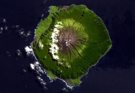
Queen Mary's Peak on Tristan da Cunha is the highest island mountain in the South Atlantic and a prominent landmark on the sea lanes around southern Africa.
Tristan Island is the youngest island in the group, at one million years, and is still considered volcanically active with its most recent eruption occurring in 1961-62.
The island is 41 km2 and has a volcanic cone that reaches 2,062 meters (m) with a base circumference of 34 km. The volcano is often snow-capped and has a crater lake.
The coast is characterized by sea cliffs of up to 600 m in height, occasionally broken by low coastal strips. Above the cliffs, a 600-900 m plateau of sorts surrounds the base of the volcano.
The island’s small settlement, called Edinburgh, is on the northwest coast.
Other islands in the group, Nightingale Island and Inaccessible Island, are eroded volcanic cones once similar in size to Tristan Island. Two small islands near Nightingale are named Stoltenhoff Island and Center, or Middle, Island.
Often referred to as the "Remotest Island in the World", Tristan Island has an unusual human history. The island group was discovered by Portuguese Admiral Tristado d'Ancunha in 1506, and was visited by sealers and whalers during the 18th century.
The British formally annexed the islands, and a small community was founded in the early 1800’s. It was garrisoned by the British in 1816 to prevent any attempt to rescue Napoleon from Saint Helena.
The island’s population had reached almost 300 in 1961, when a [[volcanic] eruption] forced the islanders to evacuate. After a period in England, the majority of the islanders chose to return to Tristan in 1963. The island’s current population has a remarkable continuity with its founding members. Tristan Islanders speak a distinct dialect of English that reflects their origins in Georgian England but is also laced with a few early Americanisms.
Gough Island (40°21'S, 09°53'W) lies approximately 425 km southeast of Tristan da Cunha, consisting of one main island and several offshore islets and rocks. Most of these are within 100 m of the main island, and the largest support vascular plants and breeding birds. Volcanic in origin, the Gough Island group covers 65 km² and has a high point of 910 m, at Edinburgh Peak.
The islands’ most recent volcanic activity occurred about 2,400 years ago; Gough was part of the same volcanic mass as the Tristan formations. Gough Island is composed of a central plateau with several mountain peaks, and the [[coast]line] is marked by cliffs of 300 m to 450 m in height with narrow boulder beaches and no sheltered harbor; the only area below 200 meters (m) altitude is at the southern end of the island.
Tristan Island, being the only permanently inhabited island in this group, has experienced the greatest degree of environmental degradation. Pressures have resulted from agriculture, overgrazing by sheep, tree removal, fire, and the introduction of exotic species. The exploitation of natural resources on Tristan was critical for human survival until the middle of this century, and some native species were almost or completely exterminated. The small community on the island has since taken several locally based measures to reverse this trend. The Island Council passed the first Protection Ordinance in 1950, and in 1994, Inaccessible Island was declared a nature reserve. This island is globally important for its endemic terrestrial species, including the flightless rail, as well as being a breeding site for many seabird species. The islanders retain the right to collect driftwood and guano from the uninhabited island.
Gough Island was exploited by sealers in the late 18th and early 19th centuries, with sealers camping on the island for considerable periods of time. They existed on seabirds and their eggs, fish, wild plants, and cultivated potatoes, which are no longer present on the island. Whaling occurred in the waters of Gough Island between 1830 and 1870, though the island remained uninhabited.
The island has been visited by scientists periodically since 1811, and meteorologists have inhabited the island since 1956. South Africa leases a site for a meteorological station on Gough Island. The meteorological station, with its associated facilities and helicopter landing site, is the only man made structure on the island.
In 1995, Gough Island and its territorial waters to three nautical miles were inscribed on the World Heritage List, only the third natural British site to be included. Justification for the listing included the fact that Gough is the largest scarcely modified cool temperate island ecosystem in the South Atlantic Ocean; for its huge fur seal and rockhopper penguin populations, endemic landbirds, plants and invertebrates; and its importance as a seabird colony.
Gough and Inaccessible Islands have been designated World Heritage Sites.
Ecologically, the islands are included within the Tristan Da Cunha-Gough Islands shrub and grasslands ecoregion.
Gough Island is one of the most important seabird colonies in the world. About 20 species of seabirds breed on the island. The Tristan Island group supports many of the same bird species as well as claiming a few unique populations. BirdLife International has classified both Tristan da Cunha and Gough as important Endemic Bird Areas. Land birds on Gough Island have been protected under the Tristan da Cunha Wildlife Protection Ordinance since 1950; the Tristan da Cunha Conservation Ordinance of 1976 then declared the island and its waters a wildlife reserve.
Only two native breeding mammals occur on the Tristan-Gough Islands. Subantarctic fur seal (Arctocephalus tropicalis) are abundant, and southern elephant seal populations (Mirounga leonina) have been increasing. Populations of these as well as local marine mammals, southern right whale (Eubalaena glacialis australis) (EN) and dusky dolphin (Lagenorhynchus obscurus), have fluctuated greatly in recent history due to hunting.
Geographic Coordinates: 37 15 S, 12 30 W
Area: 98 sq km
Coastline: 40 km
Maritime Claims:
Natural Hazards: Active volcanism. The island volcanoes of Tristan da Cunha (elev. 2,060 m) and Nightingale Island (elev. 365 m) experience volcanic activity; Tristan da Cunha erupted in 1962 and Nightingale in 2004.
Terrain: sheer cliffs line the coastline of the nearly circular island; the flanks of the central volcanic peak are deeply dissected; narrow coastal plain lies between The Peak and the coastal cliffs. The highest point is Queen Mary's Peak (2,060 m).
Climate: temperate marine; mild, tempered by trade winds (tends to be cooler than Saint Helena)
Dependency status: overseas territory of the UK

Source: Wikimedia Commons