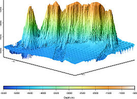
Topography
Topography is the description of the shape and features of some unit of space relative to the dimension of altitude. The most common form of displaying topography is in the form of an elevation contour map. Acquisition of topographic data may occur by onventional surveying, aerial photography, satellite imagery or, in the case of the underwater environment, by sonar or depth sensing equipment. While topography most commonly refers to surface features of the Earth, it can equally be applied to any celestial body like a moon, asteroid or planet.
Topographic information was used by ancient Chinese and Greek civilizations to add relief details to their maps. In modern times, topographic data is often collected from satellites and other spacecraft to produce precise landform characterization. Topographic maps are commonly used by civil engineers, architects and environmental scientists. Information from these maps can be used to help plan the location of a human-made reservior, design a highway, determine the layout of a golf course, map vegetation, or managing a watershed.
Contents
Data Collection
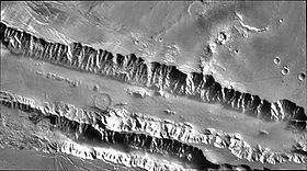
Collection of topographic data has historically been carried out by terrestrial surveying techniques, with early surveys being crude and expensive. As late as 1900, most topographic surveys in the western United States relied on expeditions with pack mules and boats.[1] By the end of the 19th century, the cost advantages of using terrestrial aerial photography from balloons for data collection become apparent and quickly made the use of this method widespread. The twentieth century ushered in advances in the use of aerial platforms for gathering topographic information from aircraft and satellites.[2] The routine use of satellite platforms to collect topographic information began with the Landsat program of NASA.[3] Subsequent missions of other spacecraft collected imagery to describe the topography of the Earth's moon and other planets in our solar system.
Conventional surveying employs simple ground based devices including astrolabe, alidad, and leveling instrument. Initial aerial photography was carried out using small propeller driven aircraft early in the second decade of the 20th century. On August 14, 1959, NASA tested the idea of satellite surveillance of Earth landforms. Photogrammetry, started in the 19th century, is the technique of making measurements from photographic data. Stereophotogrammetry is a more specialized method in which two photographs are taken from different viewing aspects, the results being analzed to yield three-dimensional or topographic relief detail of the subject area. Stereophotogrammetry is routinely used to construct accurate modern topographic maps.
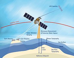
In the case of ocean topography, NASA has developed technology for accurate mapping sea surface height to within two centimeters, allowing the detection of wave heights, ocean currents, and the development of El Nino and La Nina events.
Displaying Topography
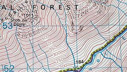
There are a variety of techniques for display of topographic data,[4] the main classes being: (a) Pictorial representation; (b) Numerical presentation (c) Contour lines; (d) Gray scale shading or color gradation; (e) Three dimensional rendering; and (f) Photographic images.
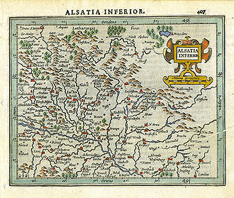
Historically, ancient maps displayed topographic data in pictorial form, with some of the earliest maps deriving from the Han Dynasty in China, where tombs at the Mawangdui archaeological site have yielded silk maps with topographic symbols. A few centuries later, the Greek academic Ptolemy is thought to have produced some of the earliest topographical symbols.[5] Some of the earliest detailed topographic maps date to the late 16th century. These maps used the technique of pictorial display to represent relief with clusters of mountain icons (see Alsatia Inferior map). These early Mercator maps were quite intricate, and the artwork was highly customized. Close inspection of the map will show that each mountain icon is custom drawn, as if to give insights to the unique local landform shapes. These maps were produced in very small numbers of typically 50 to 200 maps.
Uses of Topographic Data
A wide variety of users consult topographic information including engineers who design roads, bridges, pipelines and other major types of infrastructure. Topographic data is used in the development of land for residences, commercial and industrial buildings, and the devlopment of land for recreational purposes like golf courses, ski resorts, and camp grounds.
Scientific demand for topographic data is great, since the mapping of landforms, vegetation, microclimate, noise polution[6] and many other environmental factors relies upon a detailed understanding of topography. At the recreational level, hikers, backpackers, kayakers and nature explorers require high quality topographic information not only for determining location and direction finding, but also for the full interpretation of a wilderness experience. In terms of navigation, topographic data is essential for pilots to fly their aircraft. Sea floor topography is equally necessary for boating, fishing and shipping functions. In agriculture and forestry [7], a full understanding of the area topography is important to decisions that must be made regarding planting and harvesting crops and trees.
References
Citation
Hogan, C. (2012). Topography. Retrieved from http://editors.eol.org/eoearth/wiki/Topography- ↑ James B.Campbell. 2007. Introduction to remote sensing. Guilford Press.

