Tocatins/Pindara moist forests
Contents
Tocantins/Pindare moist forests
Biome: Tropical and Subtropical Moist Broadleaf Forests
Size: 74,700 square miles
Conservation Status: Critical/Endangered
This region hosts a rich and varied biota with some species restricted to this area at the eastern extreme of the Amazon province. The area may well be a center of diversification for many tree taxa. In this dense evergreen rain forest there is noted heterogeneity in the biota due to the presence of many rivers and to the transitional nature of the region. It hosts elements of the moist evergreen forests of the Amazon Basin in the east and north as well as the drier vegetation of Brazil’s central plateau to the south. A refugium is believed to have existed in the west of this region . One of the most developed areas of Amazonia, cities and interconnecting highways threaten most of the habitat.
Location and General Description
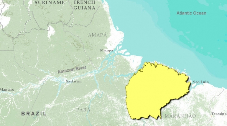
The Tocantins-Araguaia-Maranhão moist forest is an area of dense rain forest in the eastern extreme of the Amazon Basin flanked by the mouth of the Amazon River and the Atlantic Ocean. In the state of Pará, the region extends west to the Tocantins River and south to the Mearim River in Maranhão State. A number of rivers run through the region including the Gurupi, Capim, and Guamá which feed into the mouth of the Amazon and are influenced by the daily tides that push Amazon water upstream. The Pindaré and Mearim drain into the Atlantic Ocean. Most of the region lies on a flat alluvial plain which has been heavily influenced by the dynamics of the Amazon River over geologic history. The low hills (less than 200 m) of the Serra do Tiracambu and Serra do Gurupi rise in the southwest. Temperature averages 26° C over the year, and annual rainfall ranges from 1,500 mm in the southern area to 2,500 in the north near the city of Belém. A pronounced dry season brings less than 100 mm of rain falling per month for about five months. This is particularly true in northwest Maranhão. The soils are mostly poor, deeply weathered clay.
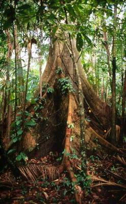
 Butress tree in the flooded coastal forest near Belem, Brazil Photograph by © WWF-Canon/Edward Parker Two main forest types occur here: terra firme (upland non-flooded forest) and flooded forest, of which there are two types: igapó, flooded daily by blackwater rivers (whose waters contain no suspended solids), and várzea, flooded daily by whitewater rivers (such as the Guamá) which contain suspended organic and mineral materials. The soils of the igapó forest are white sand, acidic, and poor in nutrients. The vegetation here is especially tolerant of these conditions. The forests are less diverse than terra firme forests and shorter.
Common species in flooded forests are Caraipa grandiflora, Virola surinamensis, Euterpe oleraceae, Ficus pulchella, Mauritia martiana, Symphonia globulifera, and species of Tovomita and Clusia . Dominant families of the terra firme include Lecythidaceae, Chrysobalanaceae, Burseraceae, Fabaceae, Lauraceae, and Sapotaceae. Prominent tree species include Lecythis odora, Lecythis turbinata, brazil nut (Bertholletia excelsa, rare in this area), Cenostigma tocantina, Bombax tocantinum, and the large liana Bauhinia bombaciflora. Mahogany (Swietenia macrophylla) is found in the Upper Capim and Guamá Rivers. Orchids are noticeably absent from this region . The important leguminous timber tree acapú, Vouacapoua americana, is restricted to eastern Amazonia north and south of the river.
Biodiversity Features
Rare or threatened trees in the area include jaborandi (Pilocarpus microphyllus), mahogany (Swietenia macrophylla), and Dicypellium caryophyllatum, a timber tree whose bark contains a pleasant-smelling essential oil. The avifauna hosts 517 bird species. Two herons are uncommon elsewhere in Amazonia (Egretta tricolor and Nyctanassa violacea). Also present are toucans (Ramphastos spp.), two guans (Pipile cujubi, Penelope pileata), many Nearctic migrants, parrots, and parakeets. Out of the 149 mammals recorded in this region, more than 80 are bats. The bearded saki (Chiropotes satanas), howler monkey (Alouatta belzebul), and red-handed tamarin (Saguinus midas) are all eastern Amazonian primates. Two species of sloths (Bradypus variegatus and Choloepus didactylus) and the nine-banded armadillo (Dasypus novemcinctus) are common here. The rivers host a great number of fish and aquatic reptiles. More than 76 species of snakes are found here.
Current Status
This is one of the most developed areas of Amazonia with several highways connecting the important cities of Belém, Paragominas, and Bragança. These big roads attract large-scale industry and development projects. At least one-third of the forests are cleared and much of this land is degraded. The region has become a mosaic of forest remnants, cattle pastures, agricultural fields, secondary forests, degraded (logged) forests, and sprawling urban areas. A great many species are rare or threatened by deforestation. The Tucuruí Dam on the Rio Tocantins below the city of Marabá has flooded 2,430 km2 of low-lying forest, drowning the flora and fauna and displacing human residents. Several small protected areas are established here, and the 2,000 km2 Caxiuanã National Forest protects some forest habitat. There is a small amount of frontier forest remaining here and that is very threatened by continued human-induced deforestation and land degradation.
Types and Severity of Threats
Colonization along roads and rivers, expansion of agriculture, cattle ranching, and urban sprawl threaten the natural habitats of this region. Fire is used as a tool to facilitate these activities, and it poses the most serious threat to the integrity of the forest ecosystems . Drought and erosion in pastures creates an environment inhospitable to rain forest tree seedlings, therefore hindering the regeneration of forest.
Justification of Ecoregion Delineation
This interfluvial ecoregion is bound on the east and across the southwest by the Tocantins River (the Tucurui Reservoir is not considered for historic coverage) and by the Pindare River and São Marcos Gulf in the east. Linework for this ecoregion follows these rivers, and the IBGE (1993) map classification of "lowland ombrophilous dense forest", "submontane ombrophilous dense forest", and all subsequent "secondary forests and agricultural activities" within this broad classification. Northern limits follow the coastal mangroves, and southern delineation follows the transition to "seasonal deciduous forest" which we classify as cerrado. The ecoregion is isolated from similar forest by the surrounding rivers, and is justified in its endemic species.
References
Ducke, A., and G. A. Black. 1953. Phytogeographical notes on the Brazilian Amazon. Anais da Academia Brasileira de Ciências 25: 1-46.
Fundação Instituto Brasilero de Geografia Estatástica-IBGE. 1993. Mapa de vegetação do Brasil. Map 1:5,000,000. Rio de Janeiro, Brazil.
Nepstad, D. C., P. R. Moutinho, C. Uhl, I. C. Vieira, and J. M. da Silva. 1996. The ecological importance of forest remnants in an eastern Amazonian frontier landscape. Pages 133-150 in J. Schelhas and R. Greenberg, editors, Forest Patches in Tropical Landscapes. Washington, DC: Island Press.
Pires, J. 1974. Tipos de vegetaçao da Amazônia. Brasil Forest 5: 48-58.
Prance, G. T. 1977. The phytogeographic subdivisions of Amazonia and their influence on the selection of biological reservers. Pages 195-212 in G.T. Prance and T.S. Elias, editors, Extinction is Forever. New York: New York Botanical Garden.
Silva, J.M. C. 1998. Um método para o estabelecimento de áreas prioritárias para a conservação na Amazônia Legal. Report prepared for WWF-Brazil. 17 pp.
Prepared by: Robin Sears

