Template:Hot Lake, Washington, USA
Contents
Hot Lake, Washington, USA
Author: C. Michael Hogan
Topic Editor: [[]]
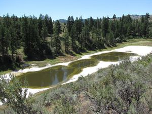
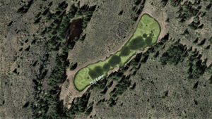
Hot Lake is located Okanagan County within the state of Washington in the USA at approximate coordinates of 48 degrees 58 minutes N and 119 degrees 29 minutes W; the closest populated center is Oroville, Washington. The lake surface area is approximately 1.27 hectares in extent.(1) This small water body is situated atop Kruger Mountain at an elevation of about 2000 feet. Hot Lake is a hypersaline lake has a maximum depth of only about 3.25 meters.(1) It is classified as a meromictic lake, or a water body with virtually no vertical mixing of its layers. (Most lakes achieve vertical mixing one or more times per year). Magnesium and sulfate are the major ions present in the lake waters.(1)
Climate
The Hot Lake vicinity is characterized by warm dry summers and moderately cool winters with moderate snowfall. Average rainfall is 48 centimeters (19 inches ) per year, with about 43 inches (109 cm) of annual The January low tempurature is typically about 18 degrees F. An average of 189 sunny days occur at Hot Lake. Relative humidity levels are low year around.
Geology
This small lake basin is a result of glacial carving, a small, with remnant surrounding features of mafic magnesian rocks, some shales and dolomites; these surrounding rocks hold deposits of pyrite and pyrrholite. Part of the lakebed sculpting results from the epsomite mining that occurred during World War I. Satellite imagery displays the lake, with its apron exhibiting a light colored salty crust similar to other hypersaline lakes such as the Dead Sea, Lake Urmia (Iran) and Lake Assal.
Hydrology
Hot Lake has no appreciable water inflow or outlet, including an abaence of subsurface feeds.(1) This absence of inlet and outlet may partially explain the lack of vertical mixing. This mildly alkaline water body realizes water loss chiefly by evaporation. The lake salinity varies by season, but generally realizes its peak salinity in late summer, achieving a level of about 200 grams per liter. The static lower lake stratum (monimolimnion) is heated directly by the sun, due to the thinness and clarity of the upper layer (mixolimnion). Summer moniolimnion teperatures reach fifty de.grees Celsius or 122 degrees Fahrenheit; surprisingly much of this elevated temperature persistos until winter, due to the lack of vertical mixing. There is a dense layer of green sulfur bacteria at the top of the moniolimnion.
A major manifestation of the lack of vertical mixing is the strong stratification of total dissolved solids (TDS). Surface waters hold about 100 grams per liter TDS, while lower level moniolimnion waters measure approximately 400 grams per liter TDS.(6)
Lake Ecology
Dominant lake flora are Widgeon-grass (Ruppia maritima), a bright green aquatic plant often found in shallow water bodies, and Chara (a stonewort genus of green algae (3) that is found in certain freshwater systems, typically submerged and anchored to the bottom. The Chara comprises an important element of the submerged phototrophic benthic mat of Hot Lake. Dominant aquatic fauna are the Brine shrimp (Artemia salina) and the Pocket-pouch fairy shrimp (Branchinecta campestris), the latter species characteristically found in warm alkaline hypersaline lakes and pools, west of the North American Continental Divide
Terrestrial Habitat
The Hot Lake watershed is within the Okanogan Dry Forests ecoregion, where dominant trees are Quaking aspen (Populus tremuloides), Ponderosa pine (Pinus ponderosa) and Douglas-fir (Pseudotsuga menziesii).The immediate habitat at the lake south is a mixed conifer forest; the adjacent setting to the north side is a woody scrub, as would be expected from this sunnier south facing slope. In the general area sunny south facing slopes feature grassland and scrub habitat dominated by Bluebunch wheatgrass (Agropyron spp.), Blue grass, June-grass (Koelaria spp.) and Sagebrush (Artemisia tridentata). Larger mammals that may be seen locally are Characteristic wildlife of this ecoregion includes Black bear (Ursus americanus), Bighorn sheep (Ovis canadensis), Black and White-tailed deer (Odocoileus hemionus and O. virginianus), Coyote (Canis latrans), Bobcat (Lynx rufus), Mountain lion (Puma concolor) and American badger (Taxidea taxus).
References
(1) G.C. Anderson. 1958. "Some Limnological Features of a Shallow Saline Meromictic Lake" (PDF). Limnology and Oceanography 3 (3): 259–270. doi:10.4319/lo.1958.3.3.0259.
(2) O.P. Jenkins (1918). "Spotted Lakes of Epsomite in Washington and British Columbia". American Journal of Science 46: 638–644.
(3) F.E.Round. 1966. The Biology of the algae. Abe Books Publisher
(4) Ernest Arnold.St.John H and W.D. Courtney (1924). "The Flora of Epsom Lake". American Journal of Botany 11 (2): 100–107. doi:10.2307/2435492.
(5) E. McKay (1935). "Salt tolerance of Ruppia maritima in lakes of high magnesium sulfate concentration". Plant Physiology 10: 425–446. doi:10.1104/pp.10.3.425.
(6)B.A. Whitton, M. Potts, eds. (2007) The Ecology of Cyanobacteria: Their Diversity in Time and Space. Springer Publishing
(7) World Wildlife Fund (2014) Okanagan dry forests Encyclopedia of Earth