Tehachapi Pass, California
 Tehachapi Pass wind farm. Photo: Martin J. Pasqualetti
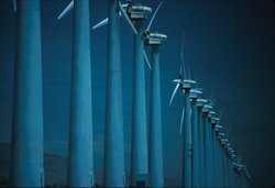
 Tehachapi Pass (35°06'50.12"N, 118°17'46.13"W, elevation 3793 ft/1156 m), a mountain pass in southern California, southeast of Bakersfield, CA, is the site of one of the world's largest wind farms. Average wind speeds approach nearly 9 meters per second (about 20 miles per hour). This places Tehachapi Pass in wind power class 6 (these classes range from class 1, the lowest, to class 7, the highest). Wind speeds are higher in April through October than in the winter months due to the extreme heating of the Mojave Desert during the summer months. The hot air over the desert rises, and the cooler, denser air above the Pacific Ocean rushes through the Tehachapi mountain pass to replace it. The predominant wind direction is from the west/northwest in the mid-spring to mid-fall and from the southeast/east during the colder months.
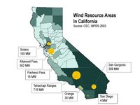 Wind resource areas in California. Image: CA Energy Commission
 The Tehachapi wind farm consists of about 3,400 wind turbines with a capacity of 710 MW annual generation of about 1.5 terrawatt hours (TWh) of electricity. The Tehachapi wind resource area is one of three primary regions, the others being Altamont and San Gorgonio. Together these three areas account for nearly 95 percent of all commercial wind power generation in California, and approximately 11 percent of the world’s wind-generated electricity. In 2004, wind energy in California produced 4,258 million kilowatt-hours of electricity, about 1.5 percent of the state's total electricity. That's more than enough to light a city the size of San Francisco.
The region is also the site of the Tehachapi Loop. Built between 1874 and 1876, it is an engineering marvel world famous for its unique solution to what was considered an unsolvable problem of building the railway through an exceptionally steep section of the mountains to the Tehachapi pass. Civil Engineer William Hood solved the problem by constructing a unique loop. A train first passes through an entry tunnel, and then does a complete counterclockwise loop, passing over the entry tunnel before continuing easterly. The loop is sized to have a length adequate to achieve the needed gain in elevation. The result is a loop 3,799 feet long, with a typical diameter of about 1,210 feet.
Further Reading
Avian Monitoring and Risk Assessment at the Tehachapi Pass Wind Resource Area; Period of Performance: October 2, 1996—May 27, 1998