Suez Canal, Egypt
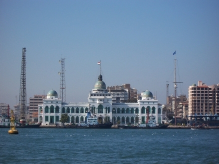
Photos taken by Daniel Csörföly, Budapest, Hungary, via Wkimedia Commons
The Suez Canal is located in Egypt west of the Sinai Peninsula, connects Port Said on the Mediterranean Sea with the port of Suez on the Red Sea, and provides an essentially direct route for transport of goods between Europe and Asia. The canal supports approximately 8% of the world’s shipping traffic with almost fifty vessels traveling throughthe canal daily.
The Canal is about 195 kilometers (121 miles) long, and 300 meters wide and a minimum channel width of 60 meters (197 feet), the Suez Canal is able to accommodate ships as large as 150,000 tons fully loaded. Because no locks interrupt traffic on this sea level waterway, the transit time only averages about 15 hours.

Contents
Geography

Structure of the Canal
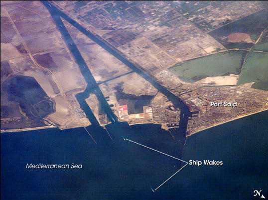 This astronaut photograph captures a northbound convoy of cargo ships entering the Mediterranean Sea from the Suez Canal in Egypt (leftmost canal branch at image center). . Credit: Astronaut photograph ISS013-E-44847 was acquired June 30, 2006, International Space Station Program crew. NASA The structure of the Suez Canal has chansiderably since it was first built; with the canal deepened from 8 m to 24 m, and broadened ro accompadate much larger ships - from 5,000 dead weight tonnage (DWT) to 240,000 DWT.
Turns in the canal have been extended to provide the larger modern ships at least 5 Km for the turns.
Bypasses have been added to the canal to allow ship to pass, and more significant to allow north bound ships to go around Port Said at the northern terminus of the canal and enter directly into the Mediterranean sea (see image right).
Studies are under way to increase the canal depth to allow ships with a draft of 72 feet. This increase is particularly significant for the largest oil tankers.
| Item | 1869 | 1956 | 1980 | 2010 |
| Overal Length (km) | 164 | 175 | 189.8 | 193.3 |
| Bypasses Length (km) | -- | 27.7 | 77 | 80.5 |
| Width at 11 meters depth (m) | -- | 60 | 160-175 | 205-225 |
| Water Depth (m) | 8 | 14 | 19.5 | 24 |
| Maximum Draft of Ship (feet) | 22 | 35 | 53 | 66 |
| Cross sectional area | 304 | 1200 | 3,250 - 3,500 | 4,800 - 5,200 |
| Max. Loaded Ship (DWT) | 5,000 | 30,0000 | 150,000 | 240,000 |
Source: Suez Canal Authority.

Source: Suez Canal Authority
History
Ancient Canals
The first canal to connect the Mediterranean Sea to the Red Sea is thought to have been dug nearly four thousand year ago, probably during the reign of the Pharao Senausret III (1887-1849 BCE) using an east-west route connecting the Red Sea to the Nile River. The success of this canal is unclear. It seems to have silted up, abandoned, and reopened on several times over a perdiod of a thousand years. " 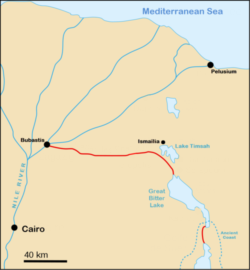 Ancient Suez Canal. Source: Wikimedia Commons
Around 600 BCE, a new canal was begun from the Pelusian branch of the Nile near the ancient city of Bubastis (near the modern city of Zagazit) in the delta to the northern end of the Bitter Lakes.
At this time the Gulf of Suez extended farther north, so that the canal needed only to reach the shore of what is now the Great Bitter Lake. This canal was completed by the Persian King Darius (550–486 BCE), who had conquered ancient Egypt.
According to the Greek historian Herodotus (c. 484 – 425BC), this canal was wide enough that two triremes (ancient rowed boats) could pass each other with oars extended, and that it took four days to navigate.
Darius erected a series of engraved granite slabs to commemorate the canal. One inscription has been translated as follows:
Saith King Darius: I am a Persian. Setting out from Persia, I conquered Egypt. I ordered this canal dug from the river called the Nile that flows in Egypt, to the sea that begins in Persia. When the canal had been dug as I ordered, ships went from Egypt through this canal to Persia, even as I intended.
As the Gulf of Suez slowly receded south, an additional canal or dredged waterway reaching south from the Great Bitter Lake was required. This was likely first completed during the reign of Ptolemy II Philadelphus (285-246 BC). After silting up and being abandoned, the canal was revised during the rule of the Roman Emperor Trajan (98-117 AD).
The canal continued to silt up, be abandoned, and reopened again, over the succeeding centuries, as Roman rule failed and the Islamic era began, until the Abbasid caliph El-Mansur closed to canal during a period of revolt, around 767 CE.
Building the Modern Canal
In 1998, Napoleon Bonaparte invaded Egypt as the first step in a plan for France to attack Britain's growing power in India. As part of the expedition, 167 French scientists and engineers undertook many studies and explorations of the region, which included the discovery of the remains of ancient east-west canal.
The possibility of a new north-south canal connecting the Mediterranean Sea to the Gulf of Suez was studied by Napoleon's engineers. However, incorrect measurements of sea level suggested that the Red Sea was 10 meters higher than the Mediterranean and that a canal would result in a steady flow from the Red Sea into the Mediterranean, raising its level and possibly flooding the Nile Delta.
Interest in a canal waned for a period, but continued to attract considerable interest, particularly in France. Interest was also advanced after it shown in 1830's and 40s that there was no difference between the two sea levels. Linant de Bellefonds (1999-1883), the chief engineer of the public works of Upper Egypt, produced plans for a canal in 1841, but received no backing from Egyptian authorities.
A key turning point was reached between 1854 and 1856, when Pasha Said (1822-1863), the Wāli of Egypt (or Governor of Egypt within the Ottoman Empire) gave approval to Vicomte Ferdinand Marie de Lesseps (1805-1894) to establish a private company to build and operate canal for 99 years. The canal was to be open to ships of all nations. After the stipulated 99 years, canal ownership would return to the Egyptian government.
The company was formed in 1858 as La Compagnie Universelle du Canal Maritime de Suez (Universal Company of the Maritime Suez Canal) owned chiefly by French and Egyptian investors (primarily Pasha Said who owned 44 percent of the company).
Excavation of the canal took ten years (1959-69), including a year after the death of Pasha Said (1863-64) when his successor Ismail (1830-1895) wished to renegotiate the agreement for the canal. On November 17, 1869, the 160 km canal was opened to ships. 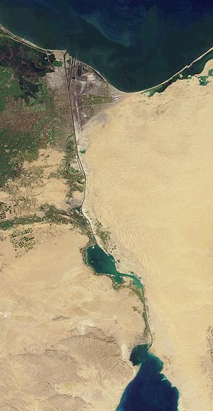 Source: NASA
Ironically, burdened by debt, the Egyptian share in the canal company was sold to the British government six years after the canal opened. Egyptian debt resulted in France and Britain gaining considerable influence over the running of Egypt, including control of financial matters, internal unrest, military intervention (1979), and finally British taking a near dominant role in most important matters of state.
At the Convention of Constantinople (1888), a commitment to being open to vessels of all nations without discrimination, including during war time, was enshrined in an international treaty.
Egyptian Control
Egypt gained a measure of independence in 1922, but France and Britain continued to operate the canal, and Britain maintained a military presence until 1954 following the establishment of the Egyptian Republic in 1953.
In July 1956, President Gamal Abdel Nasser (1918-70) nationalized the Suez canal, taking full Egyptian ownership twelve years ahead of the treaty agreement.
Suez Crisis
In the wake of the nationalization of the canal, the Suez Crisis occurred. In October 1956, Israel invaded the Sinai Peninsula as part of its continuing conflict with Arab nations, including Egypt. Simultaneously, Britain and France attempted to seize control of the canal. Egypt immediately sank all 40 ship present in the canal and, Britain and France withdrew under a barrage of international criticism, including from the United States. A United Nations Emergency Force (UNEF I) oversaw the withdrawal of non-Egyptian military forces from the Sinai and Canal Zone, and remained as peace observers until May, 1967,
Egyptian ownership of the canal was recognized internationally and placed under the control of the Suez Canal Authority, which continues to operate the canal. The canal was cleared and reopened in March, 1957.
Six Days War and Blockade
In June 1967, the Arab-Israeli war known as the Six Days War, resulted in Israeli occupation of the Sinai Peninsula, and the blockading of the Suez Canal by Egypt. The blockade would last eight years, until 1975.
In 1973, following another Arab-Israeli war (the "Yum Kippur War"), a new United Nations Emergency Force (UNEF II) was deployed to oversee the cease fire between Israel and Egypt in Sinai and Canal Zone. UNEF II remained in place until the Egypt-Israel Peace Treaty of 1979, which followed the 1978 "Camp David Accords." Under UNEF II, mines were removed from the canal in 1974 and the canal reopened in 1975.
The canal has remained open and operational since 1975.
Traffic
Ship traffic occurs in three convoys daily; two southbound leaving from Port Said starting at midnight and 7 am, and one north bound leaving Suez starting at 6 am. The Suez Canal Authority, states that:
- The convoy system allows ships to transit the Canal at fixed speed and with fixed separating distance between every two ships.
- The transit speed limit is 11 - 16 km/hr for ships according to the type & net tonage of ship and direction & speed of tidal current.
- The emergency stopping time between the ships in the convoys is about 10 min.
- Vessel takes from 12 - 16 hours to transit the canal.
- The interval between vessels in a convoy is about 10-16 minutes which is equivalent to 2-3 km distance.
- There are 15 Pilotage Stations at the western bank of the Canal that along side with the traffic control office offer assistance for the passage of vessels.
- Pilotage by SC pilots is compulsory for all transiting vessels. The SCA assigns four pilots for each transiting vessel; each one embarks and disembarks the vessel at a certain location as follows:
- The first pilot boards the vessel at the northern waiting area and disembarks at the entrance of the Canal in Port-Said.
- The second pilot boards the vessel in Port-Said and disembarks in Ismailia.
- The Third pilot boards the vessel in Ismailia and disembarks in Suez.
- The fourth pilot boards the vessel in Suez until it leaves the Canal into the open sea.
-
Oil Transit Chockpoint
The Suez Canal is considered a geographic “chokepoint” due to its influence in the world oil trade and because its narrow-width could be easily blocked, causing disruption to oil transport. In 2001, the Suez Canal transported approximately 1.3 million bbl/d of petroleum. The Sumed Pipeline has the ability to transport around 2.5 million bbl/d from the Ain Sukhna terminal at the Gulf of Suez to the Sidi Kerir at the Mediterranean Sea. Oil from the Sumed Pipeline is exported mainly to Europe and the United States. The pipeline consists of two parallel 42-inch lines and is owned by the Arab Petroleum Pipeline Company. By 2010, the Egyptian government hopes to have widened and deepened the Suez Canal enough to accommodate the passage of very large crude carriers (VLCCs) and ultra large crude carriers (ULCCs).
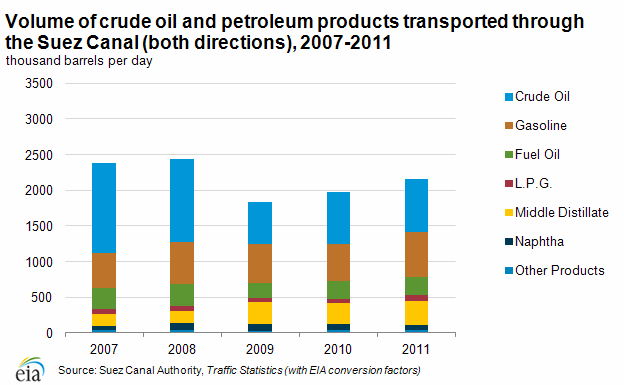
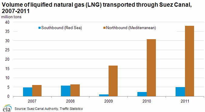
In 2011, petroleum (both crude oil and refined products) and liquefied natural gas (LNG) accounted for 15 and 6 percent of Suez cargoes, measured by cargo tonnage, respectively.
In 2011, 17,799 ships transited the Suez Canal from both directions, of which 20 percent were petroleum tankers and 6 percent were LNG tankers. Only 1,000 feet wide at its narrowest point, the Canal is unable to handle Ultra Large Crude Carriers (ULCC) and most fully laden Very Large Crude Carriers (VLCC) class crude oil tankers. The table above shows weight and capacity for the different tanker types. The Suezmax was the largest ship capable of navigating through the Canal until 2010 when the Suez Canal Authority extended the depth to 66 feet to allow over 60 percent of all tankers to use the Canal, including ships that are 220,000 of dead weight tons in size.
| Tanker Type | Deadweight Tons | Approximate Capacity (Barrels) |
Source: Clarksons | ||
|---|---|---|---|---|---|
| Panamax | 60,000 - 100,000 | 440,000 - 730,000 | |||
| Aframax | 80,000 - 120,000 | 850,000 - 880,000 | |||
| Suezmax | 120,000 - 200,000 | 880,000 - 1,500,000 | |||
| VLCC | 200,000 - 320,000 | 1,500,000 - 2,350,000 | |||
| ULCC | 320,000+ | 2,350,000+ | |||
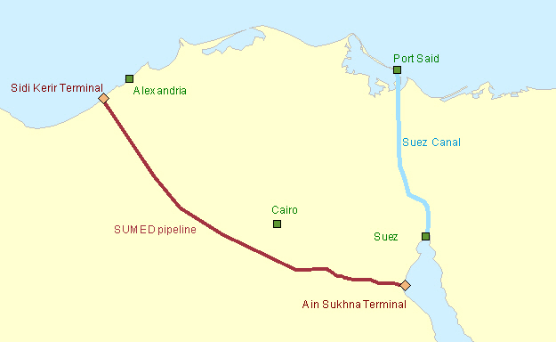
SUMED Pipeline
The 200-mile long SUMED Pipeline, or Suez-Mediterranean Pipeline, provides an alternative to the Suez Canal for those cargos too large to transit through the Canal (laden VLCCs and larger). The crude oil flows through two parallel pipelines that are 42-inches in diameter, with a total pipeline capacity of around 2.4 million bbl/d. Oil flows north through Egypt, and is carried from the Ain Sukhna onshore terminal on the Red Sea coast to its end point at the Sidi Kerir terminal on the Mediterranean. The SUMED is owned by Arab Petroleum Pipeline Co., a joint venture between the Egyptian General Petroleum Corporation (EGPC), Saudi Aramco, Abu Dhabi's National Oil Company (ADNOC), and Kuwaiti companies.
The SUMED Pipeline is the only alternative route to transport crude oil from the Red Sea to the Mediterranean if ships were unable to navigate through the Suez Canal. Closure of the Suez Canal and the SUMED Pipeline would divert oil tankers around the southern tip of Africa, the Cape of Good Hope, adding approximately 6,000 miles to transit, increasing both costs and shipping time. According to the International Energy Agency (IEA), shipping around Africa would add 15 days of transit to Europe and 8-10 days to the United States.
Fully laden VLCCs transiting toward the Suez Canal also use the SUMED Pipeline for lightering. Lightering occurs when a vessel needs to reduce its weight and draft by offloading cargo in order to enter a restrictive waterway, such as a canal. The Suez Canal is not deep enough to withstand a fully laden VLCC and, therefore, a portion of the crude is offloaded at the SUMED Pipeline at the Ain Sukhna terminal. The now partially laden VLCC then goes through the Suez Canal and picks up the portion of its crude at the other end of the pipeline, which is the Sidi Kerir terminal.
Source: U.S. Energy Information Administration
Crude Oil
The majority of crude oil transiting the Suez Canal travels northbound, towards markets in the Mediterranean and North America. Northbound canal flows averaged approximately 535,000 bbl/d of crude oil in 2011. The SUMED Pipeline accounted for about 1.7 million bbl/d of crude oil flows from the Red Sea to the Mediterranean over that same period. Combined, these two transit points were responsible for nearly 2.2 million bbl/d of crude oil flows into the Mediterranean. Northbound crude transit has declined by almost half since its level in 2008 when 943,000 bbl/d of crude transited northbound through the Canal and an additional 2.1 million bbl/d of crude travelled through the SUMED to the Mediterranean. Contrarily, crude oil shipments travelling southbound through the Canal toward the Red Sea, primarily destined for Asian markets, increased from 2008 through 2010, but fell slightly in 2011.
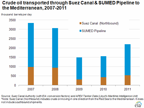
Total Oil and Products
Total oil flows from the Suez Canal declined steeply by more than one-third in 2009 to about 1.8 million bbl/d, down from 2008 levels of over 2.4 million bbl/d. Crude oil flows through the SUMED experienced a much steeper drop to1.2 million bbl/d from approximately 2.1 million bbl/d over the same period. The year-over-year difference reflects the collapse in world oil market demand that began in the fourth quarter of 2008, followed by OPEC production cuts (primarily from the Persian Gulf), which caused a sharp fall in regional oil trade starting in January 2009. Drops in transit also illustrate the changing dynamics of international oil markets where Asian demand is increasing at a higher rate than European and U.S. markets, and West African crude production is meeting a greater share of the latter's demand. At the same time, piracy and security concerns around the Horn of Africa have led some exporters to travel the extra distance around South Africa to reach West African markets. Total oil flows through the Suez Canal increased year-over year to almost 2.2 million bbl/d in 2011, but still remain below previous levels prior to the global economic downturn.
Liquefied Natural Gas (LNG)
Unlike oil, LNG transit through the Suez Canal has been on the rise since 2008, with the total number of laden tankers increasing from approximately 210 to over 500, and volumes of LNG traveling northbound (laden tankers) increasing nearly six-fold. Southbound LNG transit originates in Algeria and Egypt, destined for Asian markets while northbound transit is mostly from Qatar and Oman, destined for European and North American markets. The rapid growth in LNG flows over the period represents the startup of five LNG trains in Qatar in 2009-2010. The only alternate route for LNG tankers would be around Africa as there is no pipeline infrastructure to offset any Suez Canal disruptions. Countries such as the United Kingdom, Belgium, and Italy received over 80 percent their total LNG imports via the Suez Canal in 2010, while Turkey, France, and the United States had about a quarter of their LNG imports transited through the Canal.
Further Reading
- Suez Canal Authority
- Information on the Suez Canal (suezcanal.com)
- Canal History, Suez Canal Authority (Accessed May 16, 2013)
- Karabell, Zachary. Parting the Desert: The Creation of the Suez Canal. Knopf, 2003.