Subdivisions of the Sonoran Desert
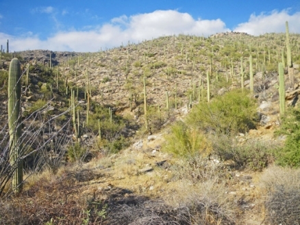
Lower western slopes of the Catalina Mountains in the Arizona Uplands. @ C.Michael Hogan
The subdivisions of the Sonoran Desert can be considered as divided into seven subdivisions. Forrest Shreve was the first person to so define the Sonoran Desert, based on the diverse and distinctive vegetation found here. One of Shreve's subdivisions (the Foothills of Sonora) has since been reclassified as foothills thornscrub, a non-desert biome.
Contents
Lower Colorado River Valley
Named for its location surrounding the lower Colorado River in parts of four states, this is the largest, hottest, and driest subdivision. It challenges the Mohave Desert's Death Valley as the hottest and driest place in North America. Summer highs may exceed 120°F (49°C), with surface temperatures approaching 180°F (82°C). The intense solar radiation (Sunlight) from cloudless skies on most days and the very low humidity suck the life-sustaining water from plants, water that cannot be replaced from the parched mineral soil. Annual rainfall in the driest sites averages less than three inches (76 mm), and some localities have gone thirty-six months with no rain. Even so, life exists here, abundantly in the rare wet years.
The terrain consists mostly of broad, flat valleys with widely-scattered, small mountain ranges of almost barren rock. There are also seas of loose sand and the spectacular Pinacate volcanic field. The valleys are dominated by low shrubs, primarily creosote bush (Larrea tridentata) and white bursage (Ambrosia dumosa). These are the two most drought-tolerant perennial plants in North America, but in the driest areas of this subdivision even they are restricted to drainageways. Trees grow only along the larger washes. The mountains support a wider variety of shrubs and cacti, but the density is still very sparse. Columnar cacti, one of the indicators of the Sonoran Desert, are rare (virtually absent in California) and are restricted to valley floors. Annual species comprise over half the flora, up to ninety percent at the driest sites; they are mostly winter growing species and appear in large numbers only in wet years.
This is the only part of the Sonoran Desert that extends into California, where most residents call it the Colorado Desert. North of a sagging line between the Coachella Valley (Palm Springs) and Needles, California, it merges almost imperceptibly into the lower Mojave Desert.
Arizona Upland
This northeastern subdivision is the highest and coldest part of the Sonoran Desert. Located in south-central Arizona and northern Sonora, the terrain contains numerous mountain ranges, and valleys narrower than those of the Lower Colorado River Valley subdivision. Much of this subdivision is drained by the Gila River. Trees are common on rocky slopes as well as drainageways, and saguaros grow on slopes above the cold valley floors. This community is also called the "saguaro-palo verde forest". It is the only subdivision that experiences frequent hard winter frosts, so many species of the lower elevation and more southerly subdivisions cannot survive here. Nevertheless it is a rich area. The small range that is the Desert Museum's home, the Tucson Mountains, has about 630 taxonomically distinct kinds of plants. This richness is partly explained by the two equal rainy seasons which total twelve inches (305 mm) per year on average. The hilly terrain provides a multitude of microhabitats on north and south slopes and deep, shaded canyons. The proximity to chaparral, woodland, and grassland communities contributes still more species to the flora.
Biologists are increasingly concluding that the Arizona Upland's climate, vegetation density, and biodiversity resemble thornscrub more than desert. Don't be surprised if this subdivision is reclassified in the near future.
Tucson is the only major city located in Arizona Upland, although much of metro Phoenix's parks and land above 2000 feet (600 m) in elevation share its characteristics. Residents who have moved to this area from temperate climates often complain about the lack of seasons. Actually Arizona Upland has five seasons which, though more subtle than the traditional temperate four, are distinct if one learns what to look for.
The following description is for Tucson, but is fairly applicable to the rest of Arizona Upland and to the eastern one-half of the Lower Colorado River Valley subdivision as well. The seasons are a little later at higher latitudes and elevations, earlier at lower ones. The monsoon is later and more sporadic farther west; in some years it fails to reach the Colorado River.
Summer monsoon or summer rainy season (early July to mid-September). In local native tradition, the year begins with the most dramatic weather event of the region— the often abrupt arrival of the summer rains. A tropical air mass brings humidity and moderates the temperatures from June's extremes; frequent thunderstorms occur; this is the main growing season for many of the larger shrubs and trees. (Monsoon is derived from an Arabic word for " season", and was applied to a wind that changes directions seasonally. Be aware that it does not refer to rain or storms per se, but rather to the shift of wind direction which brings moist air that can generate storms— in our case, a southerly wind in July. The word is often misused, even by some weather reporters.)
A sixth season, late summer, lasting from mid August through September, is sometimes added; this is a hot and dry period after the monsoon ends— nonexistent in some years.
Autumn (October & November). Warm temperatures; low humidity; little rain; few species in flower, but the growing season for winter annuals begins if there is enough rain. Late summer and autumn occasionally receive heavy rains from the remains of Pacific hurricanes (tropical storms).
Winter (December & January; sometimes February). Mostly sunny, mild days, with intermittent storms that bring wind, rain, and cool-to-cold temperatures; February often warm and dry, more spring-like .
Spring (early to late February through April). Mild temperatures; little rain; often windy; one of two flowering seasons; winter annuals may start blooming in February in warm, wet years.
Foresummer (May & June). High temperatures; very low humidity; no rain in most years; May is very warm and often windy; June is hot and usually calm. There is little biological activity except for the flowering and fruiting of saguaro and desert ironwood. Most plants and many animals are dormant until the rains arrive.
Plains of Sonora
This small region of central Sonora is a series of very broad valleys between widely separated ranges. It supports denser vegetation than does Arizona Upland because there is more rain (with summer rain dominant) and the [[soil]s] are generally deeper and finer. It contains most of the same species as Arizona Upland, plus some tropical elements, because frost is less frequent and less severe. There are abundant legume trees, especially mesquite, and relatively few columnar cacti. The few hills in this region support islands of thornscrub. Most of this subdivision has been converted to agriculture in the last few decades.
If Arizona Upland is reclassified as thornscrub, the wetter Plains of Sonora subdivision would also have to be reclassified from desert to thornscrub.
Central Gulf Coast
The Central Gulf Coast occupies a strip along both sides of the Gulf of California. Extreme aridity dictates the distinctive appearance of this subdivision. It straddles the horse latitude belt, and desert vegetation grows right to the seashore. Small shrubs are nearly absent; their shallow root systems and lack of water storage cannot sustain them through the droughts which commonly last for several years. Dominating the vegetation are large stem-succulents, particularly the massive cardón (Pachycereus pringlei, a giant relative of the saguaro), and trees such as palo verde, tree ocotillo (Fouquieria diguetii and F. macdougalii), ironwood, elephant tree (Bursera spp.), and limberbush (Jatropha spp.); the trees are leafless most of the time. The average annual rainfall of less than five inches (125 mm) occurs mostly in summer, though not dependably enough to call it a rainy season. A year with no rain is not rare.
Vizcaino
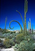 Fouquieria columaris. (Photo by Mark A. Dimmitt. © 1998 Arizona-Sonora Desert Museum)
 The Vizcaino subdivision is on the Pacific side of the Baja California peninsula. Though rainfall is very low, cool, humid sea breezes with frequent fog ameliorate the aridity. Winter rain predominates and averages less than five inches (125 mm). This subdivision contains some of the most bizarre plants and eerily beautiful landscapes in the world. There are fields of huge, sculpted white granite boulders or black lava cliffs that shelter botanical apparitions such as boojums (Fouquieria columnaris), twisted and swollen Baja elephant trees (Pachycormus discolor), sixty-foot (18 m) tall cardones, strangler figs (Ficus petiolaris ssp. palmeri) that grow on rocks, and blue palm trees (Brahea armata). In stark contrast, the coastal Vizcaino Plain is a flat, cool, fog desert of shrubs barely a foot tall, with occasional mass blooms of annual species.
Magdalena
Located in coastal Baja California south of the Vizcaino, Magdalena is similar in appearance to the Vizcaino but the species are somewhat different. Most of its meager rainfall comes in summer and the aridity is modified by Pacific breezes. The bleak coastal Magdalena Plain's only conspicuous endemic plant is the weird creeping devil cactus (Stenocereus eruca), but inland the rocky slopes are rich and dense with trees, succulent shrubs, and cacti.
Foothills of Sonora
This was Shreve's seventh subdivision of the Sonoran Desert. It has since been reclassified as foothills thornscrub community and is no longer considered part of the {C}desert biome because of its greater rainfall, taller trees and cacti, and denser vegetation.
Shreve's delineation of the Sonoran Desert's boundary and subdivisions are the most widely accepted. There are at least five other major attempts to define this area with dramatically differing boundaries. One version excludes most of Baja California from the Sonoran Desert. Another includes the Mohave as part of the Sonoran Desert. (Indeed, it is difficult to distinguish the two along the currently accepted boundary.) These differences of interpretation reflect the great diversity of geography and biota found here.
The discussion is not yet over. Time will determine whether Arizona Upland and the Plains of Sonora will remain parts of the Sonoran Desert or be reclassified as thornscrub. Whatever they are called, all of these regions are fascinating places for nature lovers, whether they are classified as scientists or tourists.
Further Reading
- Biomes & Communities of the Sonoran Desert, Arizona-Sonoran Desert Museum.
- Phillips, S.J. and P.W. Comus (eds.) 2000. A Natural History of the Sonoran Desert. Arizona-Sonora Desert Museum Press, Tucson, and University of California Press, Berkeley.
| Disclaimer: This article contains information that was originally published by the Arizona-Sonora Desert Museum. Topic editors and authors for the Encyclopedia of Earth have edited its content and added new information. The use of information from the Arizona-Sonora Desert Museum should not be construed as support for or endorsement by that organization for any new information added by EoE personnel, or for any editing of the original content. |