Southwest Plateau and Plains Dry Steppe and Shrub Province
Contents
Southwest Plateau and Plains Dry Steppe and Shrub Province (Bailey)
Texas, eastern New Mexico, 160,900 mi2 (416,700 km2)
Land-surface form
This is a region of flat to rolling plains and plateaus occasionally dissected by canyons at the western end of the Gulf Coastal Plain and the southern end of the Great Plains. The Stake Plains of Texas are included in this province. Elevations range from sea level to 3,600 ft (1,100 m) on the Edwards Plateau and to 6,500 ft (1,980 m) near the Rocky Mountain Piedmont. A mesa-and-butte landscape is characteristic of certain parts.
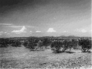 Texas landscape northwest of Amarillo. Mesquite is the principal shrub shown.
 Climate
The climate is semiarid. Summers are long and hot, and winters are short and mild. Annual temperatures average 60 to 70F (16 to 21C). The frost-free season ranges from about 130 to considerably more than 300 days. Precipitation, which falls mostly during the growing season, is about 30 in (770 mm) in the eastern part of the province and decreases to 10 to 15 in (255 to 380 mm) in the western part. Annual evaporation is 71 to 79 in (1,800 to 2,000 mm). From May to October, potential evaporation is about twice the precipitation.
Vegetation
This province is characterized by arid grasslands in which shrubs and low trees grow singly or in bunches. On the plains of northwestern Texas and eastern New Mexico, xerophytic grasses (blue grama and buffalo grass) are the characteristic vegetation. However, in much of this area, mesquite (Prosopis) grows in open stands among the grasses. On the Edwards Plateau, oak and juniper are often mixed with grasses and mesquite, and on steep rocky slopes these trees may form closed stands. Due to low rainfall, they rarely grow higher than 20 ft (6.1 m). The most characteristic tree is Ashe juniper. Over much of the Plateau, the characteristic vegetation is grass, especially prairie three-awn (needlegrass); trees and shrubs are present only in very open stands. On slopes leading down to the Rio Grande, the ceniza shrub dominates. Live oak forest is found along the Gulf Coast. A unique semiarid forest consisting of small trees and shrubs with Mexican affinities occupies the Rio Grande delta. The endangered sabal palm is native here.
Soils
Soils in this region are varied, but the different orders are well correlated with the different plant communities. The mesquite-live oak savanna, for example, is the only Entisol area in the region. Soils of the mesquite-buffalograss and juniper-oak savannas are almost entirely Mollisols; an island of Alfisols within the area corresponds to the boundaries of the mesquite-oak savanna. In the mesquite-acacia savanna, Mollisols, Alfisols, and Vertisols occur. On sandy soils in the Staked Plains of Texas, a thick growth of low shin oak practically excludes every other type of plant.
Fauna
The northern limit of distribution of several mammals coincides generally with the northern boundary of this province. The Mexican ground squirrel and gray fox live to the south of this boundary, but not to the north. Whitetail deer are abundant, and armadillo are present. The fox squirrel is hunted in wooded areas along streams. Chief furbearers are the ringtail and raccoon. The Edwards Plateau contains several scattered limestone caverns that support huge populations of Mexican freetail bats.
The threatened golden-cheeked warbler and black-capped vireo inhabit northwestern areas where the Ashe juniper is present. Wild turkey, mourning dove, scaled quail, and bobwhite are common game birds, and several species of hawks and owls are present.
Return to Ecoregions of the United States
| Disclaimer: This article is taken wholly from, or contains information that was originally published by, the United States Forest Service. Topic editors and authors for the Encyclopedia of Earth may have edited its content or added new information. The use of information from the United States Forest Service should not be construed as support for or endorsement by that organization for any new information added by EoE personnel, or for any editing of the original content. |