Southern Acacia-Commiphora bushlands and thickets
==
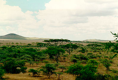
Serengeti National Park, Tanzania. (Source: Photograph by John Morrison)
In the heart of these wide-sweeping grasslands and associated Acacia-Commiphora bushlands and thickets, the world’s most spectacular migration of large mammals occurs each year. Wildebeests, Plains zebras, and Thomson’s gazelles traverse the Greater Serengeti Ecosystem (Southern Acacia-Commiphora bushlands and thickets) , triggered by cyclical wet and dry seasons. Parts of the world famous Serengeti National Park and the Ngorongoro Conservation Area are located in this ecoregion; both have been designated as World Heritage Sites and Biosphere Reserves. Of the three Acacia-Commiphora Bushland and Thickets ecoregions, this southern unit receives the most rain and is closely associated with the Serengeti Volcanic Grasslands. The main threats to the ecoregion are the same as other savanna areas in the region, poaching of large mammals for body parts and meat, and expansion of pastoralism and agricultural use of the area with associated loss of tree cover.
Location and General Description
The ecoregion is located in northern and central Tanzania, extending into southwestern Kenya, around the eastern margins of Lake Victoria. The ecoregion forms the southern border of White’s phytogeographical classification for the Somali-Masai Acacia-Commiphora deciduous bushland and thicket. The predominant plants include species of Acacia, Commiphora, and Crotalaria and the grasses Themeda triandra, Setaria incrassata, Panicum coloratum, Aristida adscencionis, Andropogon spp., and Eragrostis spp. Within Tanzania, the ecoregion is bisected by two patches of Serengeti Volcanic Grassland and patches of East African Montane Forest. The volcanic grasslands are an integral habitat of the greater Serengeti ecosystem. However, the grasslands are considered a separate ecoregion due to their unique grassland communities, found only on the fine volcanic soil, or "vertisol."
 WWF
WWF
The habitat transitions to miombo woodland towards the south, more Acacia-Commiphora Bushland and Thicket towards the north, and Zanzibar-Inhambane Coastal Forest-Savanna Mosaic towards the east. The western portion of the ecoregion is included in the greater Serengeti ecosystem. Topographically, the ecoregion is situated on the Central African Plateau and slopes upward from east to west. Elevation ranges from 900 meters (m) in the Speke Gulf up to 1,850 metres in the Gol Mountains. The majority of the ecoregion falls between 900 and 1,200 m.
The climate of the region is tropical with seasonal rain that falls in a bimodal pattern. The long rains occur from March to May and the short rains from November to December. Mean rainfall is 600 to 800 millimeters (mm) annually through most of the region. Extremes include 500 mm in the dry southeastern plains and 1,200 mm in the northwestern region located in Kenya. Rainfall is variable such that the short rains may fail in a given year or rain may occur between the two rainy seasons, thereby joining the two. Temperatures are moderate with mean maximum temperatures as high as 30°C at lower elevations and as low as 24°C at the highest parts of the ecoregion. Mean minimum temperatures are between 9° and 18°C, and normally between 13° to 16°C.
During the long dry season (August to October), the grasslands can become extremely parched, and many of the trees and bushes lose their leaves. Fires occur naturally in the ecosystem. Both fire and elephant browsing play an important role in converting dense thicket and bushland into grassland. However, a large number of fires are started by pastoralists to promote new vegetative growth for their livestock.
Geologically, the entire area is underlain by Precambrian basement rocks (up to 2.5 billion years old) that have been deformed, then eroded over hundreds of millions of years. Ultisols and alfisols lay over basement rocks, with patches of vertisols close to Lake Victoria. The hills in the ecoregion are formed of more recent sedimentary rocks, and some are recent volcanics (Igneous rock) with some active volcanoes. In many areas late Precambrian outcrops of granitic gneisses and quartzite project from the surface as inselbergs (locally called kopjes).
The human population of the ecoregion is moderate, typically between 10 and 50 persons per square kilometers (km2). The highest populations occur close to Lake Victoria and in the foothills of mountains, such as the Pare and Usambaras, in Tanzania. Large and small commercial farms have transformed the wetter areas, and small-holder farming is increasing in all suitable areas. Grazing by domestic livestock occurs in the dry areas unsuitable for cultivation.
Disease is an important variable in both the pattern of human settlement and wildlife population numbers in the region. Originally, the presence of the Tsetse fly, which carries sleeping sickness, limited the development of much of the ecoregion. Its partial eradication has made human settlement possible throughout much of the area. Outbreaks of rinderpest, a fatal disease affecting ruminants, have caused periodic, large-scale mortality in both wild antelope and domestic cattle. In 1890, 95 percent of buffalo and wildebeest in East Africa died from the disease. The continued threat of disease has resulted in conflict between pastoralists and wildlife managers over buffer zones between protected areas and grazing lands. Today, much of the land outside the protected area system has been converted to agricultural and intensive-use livestock areas. Within the Serengeti ecosystem in Tanzania, local people and their livestock utilize resources in multiple-use areas, conservation areas outside of the gazetted national parks.
Biodiversity Features
Globally, this ecoregion has outstanding concentrations of large mammals. The Serengeti-Mara migration of approximately 1.3 million wildebeest (Connochaetes taurinus), 200,000 plains zebra (Equus burchelli), and 400,000 Thomson’s gazelles (Gazella thomsoni) is the most spectacular mass movement of terrestrial animals anywhere in the world (population numbers fluctuate). This migration occurs within the southern Acacia-Commiphora bushland ecoregion for most of the year, although for part of time the majority of the animals are found on the Serengeti volcanic grasslands ecoregion.
%2c_Tanzania.jpg) Lions (Panthera leo), Tanzania. (Source: Photograph by David Olson)
Lions (Panthera leo), Tanzania. (Source: Photograph by David Olson) These species do not migrate in one synchronized trek; rather the migration occurs in waves in response to the area’s seasonal rainfall, and resulting available grazing. The plains zebras arrive in an area first and begin grazing the coarse grass stalks. Wildebeests follow and graze on the smaller grass leaves and forbs visible after the zebras consume coarse material. Thomson’s gazelles, with their smaller mouths and higher relatively energy demands, then graze the small, tender new shoots. During the wetter half of the year (December to June) the animals use the short-grass plains of the Serengeti volcanic grasslands ecoregion. During the long dry season, the animals move northward into the grasslands, savannas and shrublands of the Southern Acacia-Commiphora Bushland and Thicket. During the driest months (July to October), the animals move to the extreme northern section of the ecoregion, into Kenya’s Masai Mara game reserve. Both the distance and direction of the migration varies in relation to fluctuations in ungulate population density and rainfall patterns. Human-wildlife conflicts often occur when the ungulates traverse areas outside the gazetted protected areas, moving into agricultural lands.
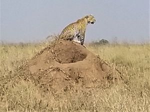
This richness of large mammal numbers is also reflected in the diversity (Species diversity) of other mammals and vertebrates. Not surprisingly the area also supports one of the highest concentrations of large predators with approximately 7500 spotted hyenas (Crocuta crocuta) and 2,800 lions (Panthera leo). Leopard (Panthera pardus), cheetah (Acinonyx jubatus), and Painted hunting dog (Lycaon pictus) can all be found here as well. However, despite this mammalian richness, there are no strictly endemic mammals, and only three small mammal species are regarded as nearly endemic.
%2c_Tanzania.jpg) Cheetah (Acinonyx jubatus), Tanzania. (Source: Photograph by David Olson)
Cheetah (Acinonyx jubatus), Tanzania. (Source: Photograph by David Olson) Both Tarangire and Serengeti National Parks have approximately 350 to 400 recorded bird species. The "Serengeti Plains" is an endemic bird area, with the restricted-range species rufous-tailed weaver (Histurgops ruficauda) (monotypic genus), Trachyphonus usambiro, grey-crested helmetshrike (Prionops poliolophus), Francolinus rufopictus, Fischer’s lovebird (Agapornis fischeri), and Karamoja apalis (Apalis karamojae, VU).
The area is also rich in both reptile diversity (Species diversity) and endemism. There are three true endemics: Amblyodipsas dimidiata, the wedge-snouted worm lizard (Geocalamus acutus), and the Mpwapwa wedge-snouted worm lizard (Geocalamus modestus). More than 10 species of reptile are also regarded as near-endemic to the ecoregion. The ecoregion is also an important habitat for the pancake tortoise (Malacochersus tornieri, VU).
Plant diversity is lower than elsewhere in the Somali-Masai regional center of endemism. Most species found here have a wide distribution throughout many of the savanna woodlands of East and southern Africa.
There are some biologically unique sites within the ecoregion. The Mkomazi Game Reserve in northern Tanzania supports some of the driest habitats within the ecoregion and is known to support invertebrates that are potential endemics.
Current Status
Areas of largely intact habitat exist throughout the ecoregion. The large number of protected areas, encompassing approximately twenty percent of the ecoregion, provides a high degree of protection to the habitats and the species they support. These are some of the better-managed protected areas in Africa. There is also a sizable portion of land protected as a multiple-use area in which both hunting and livestock grazing are permitted, with the largest area being the Ngorongoro Conservation Area. Today’s greater Serengeti-Mara protection system began with the establishment of a game reserve in the southeastern portion of this ecosystem. Gradually, Tanzania and, later, Kenya added land under protected area status until reaching the current protected system around 1967. This ecoregion includes portions or all of the following protected areas: Masai Mara National Reserve, Ruma and Ndere Island National Parks in Kenya, part of the Serengeti (some in another ecoregion), Tarangire, Ruaha National Parks, and Maswa, Mkomazi Game Reserves in Tanzania. Ruaha National Park in the southernmost portion of the ecoregion is almost as large as the Serengeti National Park. Ruaha is a connecting point between the southern Acacia-Commiphora bushland and thicket and the Central Zambezian Miombo woodlands. The Ruaha-Rungwa ecosystem has the second largest population of elephants in Tanzania (approximately 40,000).
In the past, severe elephant poaching has occurred in many areas. This has largely been mitigated due to CITES restrictions on ivory trade from declining elephant populations, and the efforts of the Tanzanian government, which brought in the army to solve some of the worst problems. Poaching of black rhinoceros has been even more severe, and the species has essentially been extirpated from most of the ecoregion, except for a few heavily protected sites. The poaching of Black rhinos is a well funded criminal supply chain, emanating from demand for horns from China, who pays a bounty to poor natives to kill the rhinos.
Outside of protected and multiple-use areas, almost all the land suitable for large-scale agriculture has already been converted. This conversion reduced the number and variety of corridors available for wildlife to move between protected areas. For example, the number of available corridors between Tarangire National Park and nearby protected areas has decreased from 30 to 4 viable corridors since the early 1970’s. Overall, the most damaged habitats in the ecoregion are located close to the mountains that rise from the plains. These areas provide a reliable source of [[rain]fall] and water for irrigation and are important for both large-scale commercial and subsistence agriculture. The areas close to Lake Victoria are mainly agricultural and have higher-than-average human population densities.
However, despite the problems in some areas of the ecoregion, there are still large areas of near-wilderness in the Tanzanian portion of the ecoregion, particularly in the Masai Steppe. These areas support few people and there remain animal populations including elephants and other large species which have been removed form areas of higher population density outside protected areas.
Types and Severity of Threats
There are three major types of threats to the long-term viability of the ecoregion’s flora and fauna: (1) loss of viable biological corridors between protected areas; (2) increased negative interactions between pastoralists and wildlife; and (3) unsustainable killing of wildlife. The last threat includes poaching for bushmeat, poaching for valuable body parts (chiefly driven by demand from China for tusk and horn material), and some instances of poorly regulated and managed game hunting concessions (permitted only in Tanzania).
While the ecoregion has large blocks of protected areas, these parks and reserves are increasingly becoming isolated islands. Loss of viable biological corridors between the areas (especially the smaller reserves) affects seasonal and drought-related movements as well as the natural migrations of species. The smallest isolated reserves are under the most threat. Expansion of the human population into the remaining habitats outside protected areas, and the increase of dryland agriculture (e.g. for tobacco) could also have a major effect on the habitat. Tobacco is a particular problem as it not only needs space for growing, but also requires fuel wood for drying. Even in the larger blocks of protected areas, competing demands between wildlife and burgeoning human populations near the borders is leading to increased conflict for resources and space.
Charcoal is made from many of the woodland tree species and is heavily used for daily cooking needs as well as for drying tobacco. The cutting of woody materials for firewood and charcoal production threatens almost all areas that have any type of human settlement. Tree regeneration is commonly very low in densely populated areas. Woodland removal results in loss of many of the small ungulate species as well as birds, reptiles and small mammals. Illegal taking of bushmeat, both for subsistence and trade, is a growing concern. An increasing reliance on bushmeat as a major protein source has resulted in localized depletions of many wildlife species, especially in areas adjacent to protected areas.
One of the largest problems associated with the growing human population (Population growth rate) is the bushmeat trade. Subsistence hunting for meat has been a part of the ecosystem since early hominid evolution. However, increasing markets for bushmeat for both rural and urban people is leading to the depletion of several antelope species. This problem is most severe in the areas outside and adjacent to the protected sites. Hunting and taking of bushmeat is an ever-increasing and serious threat to all animals throughout the ecoregion.
Uncontrolled trophy hunting within some of the Tanzanian hunting concessions may be a problem. Quota-setting and enforcement need to be carried out over an ecoregion scale, rather than by individual hunting blocks. Illegal trophy hunting and poaching are not currently large problems, partly because most black rhinoceros have been already been killed. Careful monitoring and patrolling activities need to be continued, however, to protect the large elephant populations and the few remaining black rhinoceros.
Justification of Ecoregion Delineation
This ecoregion forms the southern part of the Somali-Masai Acacia-Commiphora bushland and thicket vegetation unit of White. It contains higher levels of rainfall than the areas further north, and floristic and faunistic patterns that are distinct. It is divided from the Northern Acacia-Commiphora Bushland and Thickets ecoregion roughly by the chain of mountains along the Kenya-Tanzania border. This represents the extent of some species like the gerenuk (Litocranius walleri), which is present in the north, but is absent in much of the south. The southern boundary of this ecoregion directly follows White.
Neighbouring Ecoregions
There are several tangent ecoregions:
- At the north and mostly enveloped by the subject ecoregion are the Serengeti volcanic grasslands (AT0714) occur in two swaths just south of the Kenyan border.This world-renowned ecoregion is a stage for some of the most spectacular mass game migrations in the world. Although populations fluctuate, there are an estimated 1.3 million blue wildebeest, 200,000 plains zebra, and 400,000 Thomson’s gazelle migrating between this ecoregion and the Southern Acacia-Commiphora bushlands ecoregion each year. The migrations continue despite a devastating rinderpest outbreak in the late 19th century and indiscriminate hunting by European settlers in the early 20th century. The area represents the last remnant of a large mammal dominated ecosystem which has existed in African at least since the Pleistocene. It is relatively well protected within National Parks and Game Reserves, but populations of black rhinoceros have been extirpated by illegal hunting, and there is some evidence that illegal hunting of animals for meat is increasing.
- To the north is the Northern Acacia-Commiphora bushlands and thickets (AT0711) dominate much of lowland Kenya and extend across the border to cover a small area of northern Tanzania. The ecoregion, comprised of semi-arid mixed woodland, scrub and grassland, is reasonably protected within a well-functioning system of national parks and other reserves. However, numbers of humans and livestock are increasing outside protected areas, and nomadic pastoralism is declining in favor of settlement, causing environmental degradation through heavy grazing and agricultural expansion. Water is always in short supply in this region, where one or both rainy seasons commonly fail. Certain species such as Grevy’s zebra have undergone severe declines because of competition with livestock for, and often exclusion from, water supplies. Poaching also threatens some of the large herbivores found here, particularly the black rhinoceros and, until recently, the African elephant.
- To the west is the Central Zambezian Miombo woodlands (AT0704), which dominate the western third of Tanzania and most of its border along Lake Tanganyika. It is one of the largest ecoregions in Africa, ranging from Angola up to the southern shores of Lake Victoria. All the typical miombo flora are represented here, but this region has a higher degree of floral richness, with far more evergreen trees than elsewhere in the miombo biome. The harsh dry season, long droughts, and poor soils are ameliorated by the numerous wetlands spread throughout the ecoregion, covering up to 30 percent of the region’s total area. As a result, a diverse mix of animals is found here, from sitatunga (swamp-dwelling antelopes), to chimpanzees, in the world-famous Gombe Stream Reserve. The bird life is also exceptionally rich, as is the fauna of some amphibian groups. The ecoregion contains areas of near-wilderness with exceptionally low human populations and extensive protected areas. Other parts of the ecoregion, typically close to lakes and mountains, have higher population densities and the miombo is much more degraded. Bushmeat hunting, dryland agriculture, deforestation especially for charcoal production near larger towns, and mining are increasing threat in this ecoregion.
References
- Barnes, R.F.W., G.C. Craig, H.T. Dublin, G. Overton, W. Simons, and C.R. Thouless. 1998. African Elephant Database 1998. Occasional Paper of the IUCN Species Survival Commission No. 22. IUCN. Gland. ISBN: 2831704928
- Bell, R.H.V. 1971. A grazing ecosystem in the Serengeti. Scientific American, 224(1):86-93.
- Campbell, K., and M. Borner. 1995. Population trends and distribution of Serengeti herbivores: implications for management. Pages 117-145 in A.R.E. Sinclair and P. Arcese, editors. Serengeti II: Dynamics, Management and Conservation of an Ecosystem. University of Chicago Press. Chicago. ISBN: 0226760324
- Campbell, K., and H. Hofer. 1995. People and wildlife: spatial dynamics and zones of interaction. Pages 534-570 in A.R.E. Sinclair and P. Arcese, editors. Serengeti II: Dynamics, Management and Conservation of an Ecosystem. University of Chicago Press. Chicago. ISBN: 0226760324
- Caro, T.M., and S.M. Durant. 1995. The importance of behavioral ecology for conservation biology: examples from Serengeti carnivores. Pages 451-472 in A.R.E. Sinclair, and P. Arcese, editors. Serengeti II: Dynamics, Management and Conservation of an Ecosystem. University of Chicago Press. Chicago. ISBN: 0226760324
- Hilton-Taylor, C. 2000. 2000 IUCN Red List of Threatened Species. IUCN, Gland, Switzerland and Cambridge, United Kingdom. ISBN: 2831705657
- Hofer, H., and M. East. 1995. Population dynamics, population size, and the commuting system of Serengeti spotted hyenas. Pages 332-365 in A.R.E. Sinclair and P. Arcese, editors. Serengeti II: Dynamics, Management and Conservation of an Ecosystem. University of Chicago Press. Chicago. ISBN: 0226760324
- Kahurananga, J. and F. Silkiluwasha. 1997. The migration of zebra and wildebeest between Tarangire National Park and Simanjiro Plains, northern Tanzania, in 1972 and recent trends. African Journal of Ecology, 35:179-185.
- McNaughton, S.J. and F.F. Banyikwa. 1995. Plant Communities and Herbivory. Pages 49-70 in A.R.E. Sinclair and P. Arcese, editors. Serengeti II: Dynamics, Management and Conservation of an Ecosystem. University of Chicago Press. Chicago. ISBN: 0226760324
- Sinclair, A.R.E. 1979. The Serengeti environment. Pages 31-45 in A.R.E Sinclair and M. Norton-Griffiths, editors. Serengeti: Dynamics of an Ecosystem. University of Chicago Press, Chicago, Illinois, USA. ISBN: 0226760294
- Sinclair, A.R.E. 1995. Dynamics of the Serengeti Ecosystem: Process and Pattern. Pages 1-30 in A.R.E. Sinclair and P. Arcese, editors. Serengeti II: Dynamics, Management and Conservation of an Ecosystem. University of Chicago Press. Chicago. ISBN: 0226760324
- Sinclair, A.R.E. and P. Arcese, editors. 1995. Serengeti II: Dynamics, Management and Conservation of an Ecosystem. University of Chicago Press. Chicago. 665 p. ISBN: 0226760324
- Stattersfield, A.J. and M.J. Crosby, A.J. Long, and D.C. Wege. 1998. Endemic Bird Areas of the World: Priorities for Biodiversity Conservation. Birdlife Conservation Series #7. ISBN: 1560985747
- TRAFFIC. 2000. Food for thought: the utilization of wild meat in easternW