South Georgia
| Topics: |
This content is not assigned to a topic
|
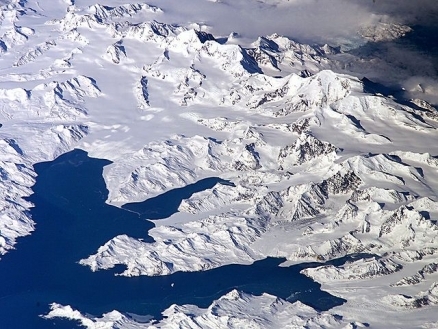
Central South Georgia: Cumberland Bay; Thatcher Peninsula with King Edward Cove (Grytviken); Allardyce Range with the summit Mt. Paget (NASA imagery).
Countries and Regions of the World Collection  South Georgiais an island group in the South Atlantic Ocean which lies about 1,390 kilometres (864 miles) east-southeast of the Falkland Islands, at 54°–55°S, 36°–38°W.
It comprises South Georgia Island itself (by far the largest island in the territory), along with the islands that immediately surround it and some remote and isolated islets to the west and east-southeast.
It has a total land area of 3,756 square kilometres (1,450 sq mi), including satellite islands.
|
|
|
|
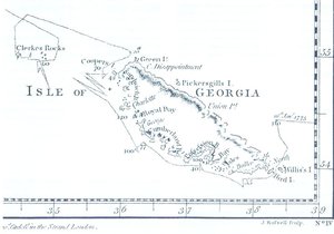 Map by James Cook (1777, South-Up) Map by James Cook (1777, South-Up) |


Themain island is rugged and mountainous.Half of theisland is permanently covered with ice and snow.
South Georgia is governed as aBritish overseas territory in combination with the South Sandwich Islands.
There is no native population on any of the islands, and the only present inhabitants are a small number of British offcials,scientists, and support staff from the British Antarctic Survey who maintain scientific bases at Bird Island and at the capital, King Edward Point, as well as museum staff at nearby Grytviken.
Contents
History
The Island of South Georgia is said to have been first sighted in 1675 by Anthony de la Roché, a London merchant, and was named Roche Island on some early maps, Pepys Island on others. It was sighted by a commercial Spanish ship named León operating out of Saint-Malo on 28 June or 29 June 1756.
In 1775 Captain James Cook circumnavigated the island, made the first landing, claimed the territory for the Great Britain, and named it "the Isle of Georgia" in honour of King George III. British arrangements for the government of South Georgia were first established under the 1843 British Letters Patent.
Throughout the 19th century South Georgia was a sealers' base and, in the following century, a whalers' base until whaling ended in the 1960s. The first land-based whaling station, and first permanent habitation, was established at Grytviken in 1904 by Norwegian Carl Anton Larsen. It operated through his Argentine Fishing Company, which settled in Grytviken. The station remained in operation until 1965.
In 1882 a German expedition sent out to observe the transit of Venus was stationed at Royal Bay on the south-east side of the island.
Whaling stations operated under leases granted by the (British) Governor of the Falkland Islands. The seven stations, all on the north coast with its sheltered harbours were, starting from the west:
- Prince Olav Harbour (from 1911–1916 factory ship and small station, land-based station 1917–1931)
- Leith Harbour (1909–1965)
- Stromness (from 1907 factory ship, land-based station 1913–1931, repair yard to 1960/1961)
- Husvik (from 1907 factory ship, land-based station 1910–1960, not in operation 1930–1945)
- Grytviken (1904–1964)
- Godthul (1908–1929, only a rudimentary land base, main operations on factory ship)
- Ocean Harbour (1909–1920)
From 1905 the Argentine Meteorological Office cooperated in maintaining the meteorological observatory at Grytviken under the British lease requirements of the whaling station until these changed in 1949.

Source: Wikimedia Commons
In 1908 the United Kingdom issued a further Letters Patent to establish constitutional arrangements for its possessions in the South Atlantic. As well as South Georgia, the Letters Patent covered the South Orkneys, the South Shetlands, the South Sandwich Islands, and Graham Land. (The claim was extended in 1917 to also include a sector of Antarctica reaching to the South Pole.) From 1909 an administrative centre and residence was established at King Edward Point on South Georgia, near the whaling station of Grytviken. A permanent local British administration and resident Magistrate exercised effective possession, enforcement of British law, and regulation of all economic, scientific and other activities in the territory, which was then governed as the Falkland Islands Dependencies.
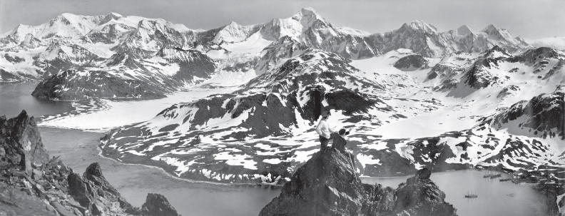
This photograph was published in the United States in Ernest Shackleton's book, South, in 1919. Photographer: Frank Hurley
In April 1916, Ernest Shackleton's Imperial Trans-Antarctic Expedition became stranded on Elephant Island, some 800 miles south west of South Georgia. Shackleton and five companions set out in a small boat to summon help, and on May 10, after an epic voyage, they landed at King Haakon Bay on South Georgia's south coast. Whilethree stayed at the coast, Shacketon and other two companions went on to cover 22 miles overland to reach help at Stromness whaling station. The remaining 22 members of the expedition, who had stayed on Elephant Island, were all subsequently rescued. In January 1922, during a later expedition, Shackleton died on board ship off South Georgia. He is buried at Grytviken.
During World War II, the Royal Navy deployed an armed merchant vessel to patrol South Georgian and Antarctic waters against German raiders, along with two four-inch shore guns (still present) protecting Cumberland Bay and Stromness Bay, manned by volunteers from among the Norwegian whalers. The base at King Edward Point was expanded as a research facility in 1949/1950 by the British Antarctic Survey (until 1962 called Falkland Islands Dependencies Survey).
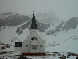 The church at Grytviken. Source:Wofratz/Wikipedia
 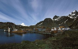 View of Grytviken.
 With the end of the whaling industry the stations were abandoned. Apart from a few preserved buildings such as the museum and church at Grytviken, only their decaying remains survive.
Argentina claimed South Georgia in 1927 (Georgias del Sur). The Argentine claim over South Georgia contributed to the 1982 Falklands War.OnMarch, 19,1982 when a group of Argentinians, posing as scrap metal merchants, occupied the abandoned whaling station at Leith Harbour on South Georgia. On April 3 the Argentine troops attacked and occupied Grytviken. The island was recaptured by British forces on 25 April (Operation Paraquet).
After the Falklands War in 1982, a full-time British military presence was maintained at King Edward Point. This was scaled down during the 1990s, and the last detachment left South Georgia in March 2001, when the new station was built and occupied by the British Antarctic Survey. The main British military facility in the region is at East Falkland (and HMS Endurance) on BSES Expeditions. Other than that, a handful of British naval vessels patrol the region. They visit South Georgia a few times each year, sometimes deploying small patrols of infantry. Flights by RAF C130 Hercules and VC10 aircraft occasionally patrol the territory.
From 1985, South Georgia and the South Sandwich Islands (sometimes referred to as "SGSSI") ceased to be administered as a Falkland Islands Dependency and became a separate territory. The King Edward Point base, which had become a small military garrison after the Falklands war, returned to civilian use in 2001 and is now operated by the British Antarctic Survey.As there are no permanent inhabitants on the islands, there is no legislative council and no elections are held. The UK Foreign Office manages the foreign relations of the territory.
ABritish Royal Navy ice patrol ship, operates in the South Georgia area during part of most southern summer seasons. She carries out hydrological and mapping work as well as assisting with scientific fieldwork for the British Antarctic Survey, high-profile film and photographic units, and youth expedition group
The Argentinian claim to the Island continues and dispute remains unresolved to this day.
Geography
South Georgia Island, also called Pepys Island (San Pedro in Spanish), lies at 54o15'S 36o45'W and has an area of 3,528 km². It is mountainous and largely barren. Eleven peaks rise to over 2,000 metres (6,562 ft) high, their slopes furrowed with deep gorges filled with glaciers (Fortuna Glacier being the largest). The highest peak is Mount Paget in the Allardyce Range at 2,934 metres (9,626 ft).
Geologically, the island consists of gneiss and argillaceous schists, with no trace of fossils, showing that the island is, like the Falkland Islands, a surviving fragment of some greater land-mass now vanished, most probably indicating a former extension of the Andean system.
Smaller islands and islets off the coast of South Georgia Island include:
- Annenkov Island
- Bird Island
- Cooper Island
- Grass Island
- Pickersgill Islands
- Welcome Islands
- Willis Islands
- Trinity Island
The following remote rocks are also considered part of the South Georgia Group:
- Shag Rocks185km (115mi) west-northwest of South Georgia Island
- Black Rock 169km (105mi) west-northwest of South Georgia Island and 16km (10mi) southeast of the Shag Rocks
- Clerke Rocks 56km (35mi) east-southeast of South Georgia Island
Climate
The permanently cold sea maintains a cold maritime climate on the islands, and the weather is very variable and harshTypical daily maximum temperatures in South Georgia at sea level are around 0°C (32°F) in winter (August) and 8°C (46°F) in summer (January). Winter minimum temperatures are typically about −5°C (23°F) and rarely dip below −10°C (14°F). Annual precipitation in South Georgia is about 1500mm (59 in), much of which falls as sleet or snow, which is possible in any month. Inland, the snow line in summer is at an altitude of about 300m.
Westerly winds blow throughout the year interspersed with periods of calm. This gives the eastern side of South Georgia (leeward side) a much more pleasant climate than the exposed western side. The prevailing weather conditions generally make the islands difficult to approach by ship, though the north coast of South Georgia has several large bays which provide good anchorage. During mountain wind conditions, the winds blow straight up the western side and straight down the eastern side of the mountains and become much warmer and drier; this produces the most pleasant conditions when temperatures can occasionally rise over 20°C on summer days. The highest ever recorded temperature was 23.5°C at Grytviken.
The seas surrounding South Georgia are cold throughout the year due to the proximity of the Antarctic Current. They usually remain free of pack ice in winter, though thin ice may form in sheltered bays, and icebergs are common. Sea temperatures drop to 0°C in late August and rise to around 4°C only in early April.
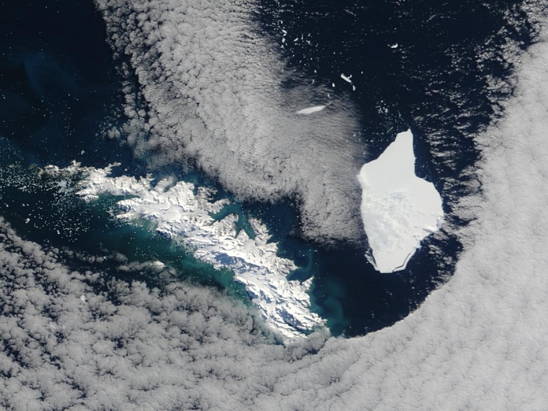
Between April 12 and April 15, the A38-B iceberg split in half. The split was recorded in this series of Moderate Resolution Imaging Spectroradiometer (MODIS) images. The iceberg was originally part of the massive A-38 iceberg, which broke from the Ronne Ice Shelf in Antarctica around October 13, 1998. At the time, the A-38 iceberg was more than 90 miles (144 km) long and 30 miles (48 km) wide, the largest iceberg that had been observed in a decade. By October 22, 1998, A-38B had started to break off the original iceberg. The pieces drifted about 1,500 nautical miles north to their present location around South Georgia Island in the South Atlantic.
On April 12, 2004, the A-38B iceberg was intact. The next time MODIS flew over the iceberg on April 15, A-38B had broken in half. The eastern half of the iceberg is now called A-38G. It measures 12 by 38 nautical miles (22 by 70 km) in size. The western half, still called A-38B, is only slightly smaller at an estimated size of 10 by 38 nautical miles (19 by 70 km). By April 17 and April 18, A-38G, right, had moved quickly north and turned west. The remaining section of A-38B appears to be grounded.
Another section of the A-38 iceberg, A-38D, was covered in melt water ponds as it drifted past South Georgia Island in late January 2004—the height of the summer in the Southern Hemisphere.
Iceberg measurements courtesy United States National Ice Center.
Source: NASA. Credit: Jeff Schmaltz, MODIS Rapid Response Team, NASA/GSFC
Flora and Fauna
TheCommonwealth association of nationslinked historically with the British Empire reports:
South Georgia is the breeding ground for some 95% of the world’s Antarctic fur seal population as well as globally significant populations of elephant seals, albatrosses, petrels and penguins. Reindeer were introduced in about 1911 by Norwegian whaling companies. Only the coastal fringes of South Georgia support vegetation, mainly in the form of tussock grass. The Government of South Georgia and the South Sandwich Islands recognises the islands’ significance for global conservation and is committed to providing a sustainable policy framework, which conserves, manages and protects the islands’ rich natural environment while at the same time allowing for human activities and for the generation of revenue which allows this to be achieved. This framework was set out in the 2000 South Georgia Environmental Management Plan. The South Sandwich Islands represent a maritime ecosystem scarcely modified by human activities.
South Georgia supports a great number of sea birds, including penguin, a large colony of petrel and prions of various other species, along with shags, skua, gull, terns, South Georgia Pipits and Seals. There is only one land species which is unique to the archipelago however, the whale.
Native vegetation on South Georgia is limited to lichenes, fernes,and a few other small flowering plants. A number of other introduced species have become naturalised. There are no trees or shrubs.
Economic
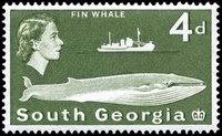 This postage stamp depicting a fin whale was issued in 1963. source: Wikipedia.
 As there are no native inhabitants, economic activity in South Georgia and the South Sandwich Islands is limited. The territory has revenues of UK£3.9 million, 90% of which is derived from fishing licences (2002 figures. Other sources of revenue are the sale of postage stamps and coins, tourism and customs and harbour dues.
Fishing
Fishing takes place around South Georgia and in adjacent waters in some months of the year, with fishing licences sold by the territory for Patagonian toothfish, cod icefish and krill. Fishing licences bring in a handful of million pounds a year, most of which is spent on fishery protection and research. All fisheries are regulated and managed in accordance with the Convention for the Conservation of Antarctic Marine Living Resources (CCAMLR) system. In 2001, the South Georgia government received a certificate from the Marine Stewardship Council for its sustainable Patagonian toothfish fishery, which certifies that they met the MSC's environmental standards and places limits on the timing and quantity of Patagonian toothfish that may be caught.
Tourism
Tourism has become a larger source of income in recent years, with many cruise ships and sailing yachts visiting the islands (the only way to visit South Georgia is by sea). The territory gains income from landing charges and the sale of souvenirs. Cruise ships often combine a Grytviken visit with a trip to the Antarctic Peninsula. Charter yacht visits usually begin in the {C}Falkland Islands, last between four and six weeks, and enable guests to visit remote harbors of South Georgia and even the {C}South Sandwich Islands. Sailing vessels are now required to anchor out and can no longer tie up to the old whaling piers on shore.
Further Reading
- A Voyage Round the World in His Britannic Majesty's Sloop Resolution Commanded by Capt. James Cook, during the Years 1772, 3, 4 and 5 (2 vols.), George Forster,London, 1777.
- The Island of South Georgia, R.K. Headland,Cambridge University Press, 1984.
- South Georgia government website
- Historia General de las Relaciones Exteriores de la República Argentina
- Antarctic Oasis: Under the Spell of South Georgia, Tim carr and Pauline Carr, W. W. Norton & Company, 1998 ISBN: 0393046052.
- General Survey of Climatology V12, 2001, Edited by Landsberg, Elsevier publishing
- Commonwealth Secretariat website
- Template:CIA World Factbook link
- Template:Dmoz
- South Georgia Association website
- South Georgia Heritage Trust
- Live picture from the South Georgia webcam
- South Georgia Wiki
- South Georgia (Russian)