Simpson desert
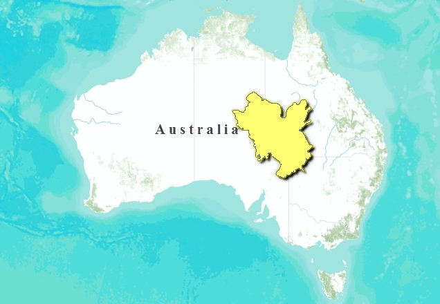
Located in arid central Australia, the Simpson Desert Region is centered on one of the world’s largest endorheic, or internal, drainage basins. This region includes Lake Eyre, Australia’s largest lake and the fifth largest terminal lake in the world. The landscape is subdued, characterized by flood- and alluvial plains, ephemeral lakes and claypans, dunefields, gently undulating stony plains, and low eroded ranges and mesas. Most of the region retains native vegetation cover with relatively pristine biota. Of particular importance to biodiversity are the large number of seasonal, and often semi-saline wetlands. Many of these areas teem with birds and fish when flooded, and are recognized internationally for their important breeding and habitat for large numbers of waterbirds.
Location and General Description
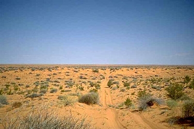
The region is located within arid central Australia where rainfall is less than 400 millimeters (mm) per year. The northern parts of the region contrast sharply with the clay plains of the Mitchell Grass Downs to the north and the central Australian ranges and shrublands to the west. To the east the region merges into the infertile mulga shrublands. To the south the region can be distinguished from the chenopod shrublands and grasslands of the Tirari-Stuart Stony Desert. The landscape is subdued, ranging from below sea level to approximately 300 meters (m) above sea level.
Vast, flat floodplains are associated with major drainage systems, particularly in the northeastern parts of the region. These are often covered by braided watercourses and referred to locally as the "Channel Country". The floodplains drain into terminal swamps, lakes, or backplains. Gently undulating plains on Cretaceous sediments surround the floodplains, often with a duricrust forming a dense gravel or rock (gibber) surface pavement. Low ranges and mesas with less than 100 meters in local relief are scattered across the region. They are found on deeply weathered substrates, sometimes made of limestone, and cover rocky skeletal soils across the region.
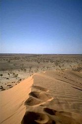
The southern and western parts of the region are dominated by dunefields 5 m to 10 m in height, formed from Quaternary sands deposited by wind over Quaternary clay sheets. Interdune areas may be covered in sandplains, traversed by seasonal drainage lines, or contain claypans or large saline lakes. A unique type of wetland, mound springs are formed around natural outlets from the Great Artesian Basin aquifer that underlies most of the region. These cover a very small area but are have very important biodiversity value in the arid environment.
The area is drained by large river systems such as the Georgina, Eyre, Cooper, Strezelecki, and Diamantina or by smaller local rivers and creeks. Many of these systems arise outside the region, but together form one of the world’s largest endorheic drainage basins, which occupies one sixth of Australia. Large floods drain into the larger lakes of the region, including Lake Eyre, Australia’s largest lake and the fifth largest terminal lake in the world.
The floodplains and surrounding stony plains are mainly covered by ephemeral grass and herblands. Common dominant genera and families include Astrebla, Eragrostis, Asteracea, Sclerolaeana, and Atriplex. The watercourses of the region are lined with low open coolibah (Eucalyptus coolibah) woodlands while swamps contain Muehlenbeckia and Chenopodium shrublands, Eragrostis australasica grasslands, or ephemeral herblands. The ranges are mostly covered by Senna or Acacia sparse shrublands.
The dunefields support a complex pattern of vegetation. Dune crests are held together by Zygochloa paradoxa grassland although mobile crests may be covered by red sand. Side slopes and sandy interdune areas are covered in Triodia hummock grasslands or herblands. Interdune areas may also include gidgee (Acacia geoginea) or coolibah woodlands on drainage lines. The claypans and larger saline lakes are often bare when not filled with water, although an ephemeral herbland will quickly arise after floods, regularly fringed with samphire (Halosarcia spp.) and mixed herblands.
Biodiversity Features
At least 34 native mammals, 231 birds, 22 amphibians, 13 fish, and 125 reptile species have been recorded from the region. The Simpson Desert has a relatively high fauna species richness compared to other arid zone regions in Australia, possibly due to the proximity of large areas of floodplains to an array of other more arid habitat types. The eucalypt woodlands, which are mostly confined to watercourses, have the highest number of species recorded compared to all other broad habitat types, particularly for bird, bat, and frog species. Spinifex grasslands also provide a rich habitat, especially for reptile species, while the herb fields on floodplains have relatively few species recorded from it. Species endemic to this ecoregion include the grey grasswren (Amytornis barbatus) and the kowari (Dasycercus byrnei), which is listed as vulnerable on the 2000 IUCN Red List.
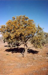
 Gidgee tree (Acacia Georginae) in the Simpson Desert, Queensland, Australia. (Photograph by Coast to Coast Tours)
 In a study on the northern parts of the region McFarland found that only 3 percent of the total number of fauna species recorded in the region were classified as rare or threatened. However a high number of mammal species, 14 percent of the total mammalian fauna, are considered regionally or globally threatened, including the greater bilby (Macrotis lagotis VU), hairy-footed dunnart (Sminthopsis hirtipes), dusky hopping mouse (Notomys fuscus VU), mulgara (Dasycercus cristicauda VU), and kowari.
Species abundance and distribution in the region show substantial temporal variations associated with seasonal conditions and faunal requirements for different habitat types at different times. Many other species, such as dasyurid mammals, also undergo dramatic population increases during better seasons, followed by population crashes in drier times when they possibly retreat to refuge areas.
A distinctive feature of this arid region is the relatively frequent floods, caused by rainfall that occurs outside the region. These events move water through the floodplains every 2 to 3 years, and reach into the terminal lakes and swamps at longer intervals ranging from 5 to 20 years. These events create wetlands and trigger rapid vegetation growth, providing unique and important wildlife [[habitat]s].
The larger lakes are normally dry, bare lakebeds, but when flooded they support large bird populations, and in the case of the larger lakes, abundant fish populations. The wetlands in this region are recognized as important breeding sites and valuable habitat for large numbers of aquatic birds. The Australian Nature Conservation Agency has listed many important wetland sites in the region, including the Coongie, Eyre, Yamma Yamma, and Bulloo Lakes and swamps associated with the floodplains of the Cooper and Strezelecki Creeks and Diamantina River.
Bird species utilizing the wetlands in this region include freckled duck (Stictonetta naevosa), musk duck (Biziura lobata), black swan (Cygnus atratus), silver gulls (Larus novaehollandiae), Australian pelican (Pelecanus conspicillatus), great egret (Egretta alba), glossy ibis (Plegadis falcinellus), and banded stilts (Cladorhynchus leucocephalus). The Coongie Lakes are considered one of the ecologically richest wetlands in Australia and have been listed as a wetland of international importance under the RAMSAR convention.
The Mound Springs are a unique permanent wetland habitat in an otherwise arid environment. They provide habitat for several endemic plant and snail species, particularly invertebrates and fish. The springs in this region include some of the largest and most actively flowing complexes in Australia and are of global significance.
Current Status
The dominant industry in the region is cattle grazing with lesser areas used for other purposes such as mining and tourism. Most individual properties cover large areas, greater than 4,000 square kilometers (km2), and are run by large pastoral companies. This area is one of the most sparsely populated regions in Australia. The major towns in the region are Bedourie, Birdsville, Innaminka, Thargomindah, and Windorah.
Most of the region retains native vegetation cover with relatively pristine biota. There is virtually no large-scale land clearance in the region, apart from narrow excavation for gas pipelines that traverse the area. There are very few exotic weed species present in the region. There is widespread grazing throughout the region, by both domestic stock and introduced animals, particularly rabbits, but also camels, pigs, and goats. Pasture resources of the region as a whole are in reasonable condition. The river systems have retained their natural hydrology regimes with minimal water harvesting in comparison to other regions of Australia.
National Parks and major conservation areas overlapping with or contained within the ecoregion include the Simpson Desert (10,120 km2), Goneaway (250 km2), Diamantina (part of 4,700 km2), Lochern (240 km2), Bladensburg (850 km2), Welford (part of 1,240 km2), Witjira (7,770 km2), Sturt (3,100 km2), and Lake Eyre (12,280 km2) National Parks as well as the Simpson Desert Conservation Park (6,330 km2) and Innamincka (13,830 km2) and Simpson Desert (2,364,200 km2) Regional Reserves. These areas cover the range of habitat types that occur in the region under varying conservation management. However, significant wetlands in the northern part of this arid region are poorly represented in protected areas.
Types and Severity of Threats
Localized impacts by grazing animals, particularly on critical habitat areas such as waterholes and breeding sites, can be severe and are likely to have major impacts on wildlife. Introduced predators such as foxes and cats, are a major threat to biodiversity in the region, because they prey on and compete with native fauna. There have also been changes to natural fire regimes, particularly in spinifex sandplains and dunefields where fire frequency has been reduced. Changes in vegetation structure and composition are likely to result. The direct impacts of mining are generally confined to localized areas, although indirect impacts caused by the introduction of weed species and the utilization of underground water may be more severe.
The unique mound springs are threatened by weed infestation, trampling by domestic stock and feral animals, and exotic fish species such as eastern gambusia (Gambusia holbrooki), and extraction of water from the Great Artesian Basin aquifer which leads to decline and extinction of springs.
Justification of Ecoregion Delineation
The Simpson Desert ecoregion comprises two IBRAs, ‘Channel Country’ and ‘Simpson-Strzelecki Dunefields’.
Additional information on this ecoregion
- For a shorter summary of this entry, see the WWF WildWorld profile of this ecoregion.
- To see the species that live in this ecoregion, including images and threat levels, see the WWF Wildfinder description of this ecoregion.
- World Wildlife Fund Homepage
Further Reading
- Australian Nature Conservation Agency. 1996. A Directory of Important Wetlands in Australia, Second Edition. ANCA, Canberra.
- Ford, G. 1995. A survey and inventory of wetlands in the Channel Country, South-western Queensland. Report to Australian Nature Conservation Agency, Department of Environment and Heritage, Toowoomba.
- Humphries, S.E., R.H. Groves, and D.S. Mitchell. 1991. Plant invasions of Australian ecosystems. A status review and management directions. Kowari 2:1-134. Australian Nature Conservation Agency, Canberra.
- Kingsford, R.T., R. Forster Levy, and J.L. Porter. 1994. An aerial survey of wetland waterbirds in eastern Australia - October 1992. Occasional Paper Number 16. New South Wales National Parks and Wildlife Service, Sydney.
- McFarland, D. 1992. Fauna of the Channel Country Biogeographic Region, South-west Queensland. Unpublished report to Department of Environment and Heritage.
- Morton, S.R. 1990. The impact of European settlement on the vertebrate animals of arid Australia: a conceptual model. Proceedings of the Ecological Society of Australia, 16:201-13.
- Ponder, W.F. and G.A. Clark. 1990. A radiation of Hydrobiid snails in threatened artesian springs in western Queensland. Records of the Australian Museum. 42:301-363.
- Thackway, R. and I.D. Cresswell. 1995. An Interim Biogeographic Regionalisation for Australia: A framework for establishing a national system of reserves, Version 4. Australian Nature Conservation Agency, Canberra, Australia.
- Tothill, J.C. and C. Gillies. 1992. The Pasture Lands of Northern Australia: their condition, productivity, and sustainability. Tropical Grassland Society of Australia, Occasional Paper No. 5.
- Wilson, B.A. 1999. Channel Country. Pages 5/1 - 5/30 in P.S. Sattler and R.D. Williams, editors. The conservation status of Queensland’s Bioregional Ecosystems. Environmental Protection Agency, Brisbane.
| Disclaimer: This article is taken wholly from, or contains information that was originally published by, the World Wildlife Fund. Topic editors and authors for the Encyclopedia of Earth may have edited its content or added new information. The use of information from the World Wildlife Fund should not be construed as support for or endorsement by that organization for any new information added by EoE personnel, or for any editing of the original content. |


