San Joaquin Basin (Bailey)
Contents
Lithology and Stratigraphy
This subsection contains late Quaternary alluvium.
Geomorphology
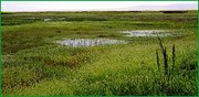
This subsection is on nearly level floodplains and basin floors. The subsection elevation range is about 60 to 100 feet. Fluvial erosion and deposition are the main geomorphic processes.
Soils
The soils are mostly Vertic and Cumulic Haplaquolls, Albic and Glossic Natraqualfs, Aeric and Vertic Haplaquepts, and Aquic subgroups of Xerochrepts, Chromoxererts, Haploxerolls, Haploxeralfs, and Natrixeralfs. Pachic Haploxerolls and Fluvaquentic Haploxerolls are common on levees along streams. Sodium accumulates in soils with slowly permeable subsoils. Most of the soils are poorly drained, and some along streams are well to moderately well drained. Soil temperature regimes are thermic. Soil moisture regimes are mostly aquic, with some xeric.
Vegetation
The predominant natural plant communities are Emergent aquatic communities and Allscale series.
Characteristic series by lifeform include:
Climate
The mean annual precipitation is about 8 to 10 inches. It is practically all rain. Mean annual temperature is about 59° to 62° F. The mean freeze-free period is about 250 to 275 days.
Surface Water
The San Joaquin River and lateral streams flood most of this area periodically. The streams and overflow channels in this subsection run parallel to the San Joaquin River. There are no permanent lakes.