Saint Pierre and Miguelon
| Topics: |

Countries and Regions of the World Collection  There are eight small islands in the Saint Pierre and the Miquelon groups in the North Atlantic Ocean, south of Newfoundland (Canada). They are home to slightly under six thousand people, five thousand of whom live in the town of Saint-Pierre.
First settled by the French in the early 17th century, the islands are a self-governing territorial overseas collectivity of France, represent the sole remaining vestige of France's once vast North American possessions.
|
|
|
|
| Map in French of the Exclusive Economic Zone of the French overseas collectivity of Saint Pierre and Miquelon off the south coast of Newfoundland, Canada, with simplified bathymetric contours. Source: Eric Gaba/Wikimedia Commons. |
|
|


The islands are mostly barren rock with scanty vegetation.
Persistent fog throughout the year can be a maritime hazard.
Recent test drilling for oil in waters around Saint Pierre and Miquelon may bring future development that would impact the environment.
This island archipelago off the coast of Newfoundland bears the scars of a complicated geologic history.
Saint Pierre and Miquelon cover just 242 sq km (93 sq mi), and the three biggest islands lend the entire archipelago its name.
Geography
Location: Northern North America, islands in the North Atlantic Ocean, south of Newfoundland (Canada)
Geographic Coordinates: 46 50 N, 56 20 W
Area: 242 sq km
Coastline: 120 km
Maritime Claims:
Natural Hazards: Persistent fog throughout the year can be a maritime hazard.
Terrain: mostly barren rock. The highest point is Morne de la Grande Montagne (240 m).
Climate: cold and wet, with considerable mist and fog; spring and autumn are often windy.
People and Society
Population: 5,831 (July 2012 est.)
Ethnic Groups: Basques and Bretons (French fishermen)
Age Structure:
0-14 years: 17.1% (male 518/female 487)
15-64 years: 67.1% (male 2,004/female 1,949)
65 years and over: 15.8% (male 379/female 551) (2011 est.)
Population Growth Rate: -0.978% (2012 est.)
Birthrate: 8.06 births/1,000 population (2012 est.)
Death Rate: 8.92 deaths/1,000 population (July 2012 est.)
Net Migration Rate: -8.92 migrant(s)/1,000 population (2012 est.)
Life Expectancy at Birth: 80 years
male: 77.72 years
female: 82.41 years (2012 est.)
Total Fertility Rate: 1.55 children born/woman (2012 est.)
Languages: French (official)
Literacy (age 15 and over can read and write):
Urbanization: 91% of total population (2010) growing at an annual rate of change of 0.1% (2010-15 est.)
Government
Dependency Status: self-governing territorial overseas collectivity of France
Capital: Saint-Pierre - 5,000 (2009)
Resources
Natural Resources: fish, deepwater ports
Land Use:
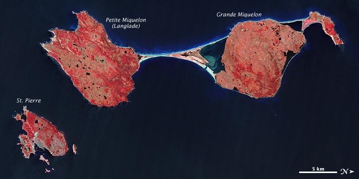
The Advanced Spaceborne Thermal Emission and Reflection Radiometer (ASTER) on NASA’s Terra satellite captured this image of Saint Pierre and Miquelon on May 23, 2009. In this false-color image, vegetation appears in varying shades of pink and red, bare land is beige, urbanized areas are blue-gray, and water appears in shades of blue and blue-green.
Saint Pierre is the smallest of the archipelago’s major islands, a mostly northeast-southwest running landmass with several smaller islands and islets scattered around it. In the west (top of the image), Miquelon consists of three main sections: an arc-shaped body in the north (top right), Grande Miquelon immediately southeast of that, and Langlade (or Petite Miquelon) Island in the south. Grande Miquelon and Langlade are connected by a tombolo, a ridge of beach material (typically sand), built by wave action, that connects an island to the mainland. This tombolo formed in the eighteenth century.
The terrain of the archipelago consists of mostly barren rock. Deforestation has claimed much of the vegetation, although woodland still covers 20 percent of the surface. Scrub vegetation and peatland are extensive. Cold, wet, foggy weather predominates, with windy springs and autumns.
The islands, particularly Langlade, bear a scoured appearance, and this is no coincidence. During the Pleistocene Ice Age, glacial ice scraped the island. Evidence of glacier movement lingers in the form of erratics and flour—fine-grained sediments ground off rocky surfaces by slow-moving ice—that overlie older rock layers. Under the erratics and glacial till, rocks date back to the Paleozoic Era, which ended roughly 250 million years ago.
Just as ice battered the land surface during the Pleistocene, wind and waves continue to erode these landmasses today. For several months a year, winds regularly exceed 60 kilometers (35 miles) per hour, and frequent storms pound the coastlines with high waves. In January 1987, a storm carved 5 meters (16 feet) off the some of the archipelago’s cliffs. Another storm in February 1988 brought winds of 160 kilometers (100 miles) per hour that took away another 14 meters (46 feet). Anecdotal evidence from local fishermen suggests that recent mild winters and less extensive sea ice might have allowed more erosion by ocean waves.
Photo courtesy of NASA. Earth Observatory image created by Jesse Allen and Robert Simmon, using data provided courtesy of NASA/GSFC/METI/ERSDAC/JAROS, and U.S./Japan ASTER Science Team. Caption by Michon Scott.
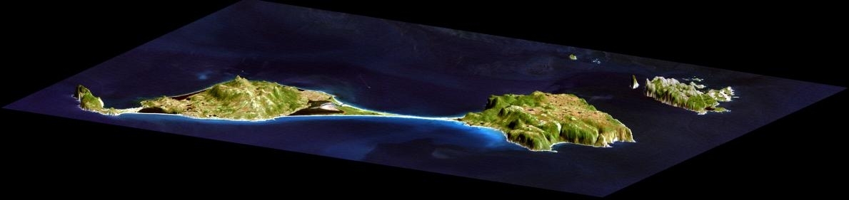
This image shows how data collected by the Shuttle Radar Topography Mission (SRTM) can be used to enhance other satellite images. Color and natural shading are provided by a Landsat 7 image acquired on September 1, 1999. Terrain perspective and shading were derived from SRTM elevation data acquired on February 12, 2000. Topography is exaggerated by about six times vertically. The United States Geological Survey's Earth Resources Observations Systems (EROS) DataCenter, Sioux Falls, South Dakota, provided the Landsat data.
Elevation data used in this image was acquired by the Shuttle Radar Topography Mission (SRTM) aboard the Space Shuttle Endeavour, launched on February 11,2000. SRTM used the same radar instrument that comprised the Spaceborne Imaging Radar-C/X-Band Synthetic Aperture Radar (SIR-C/X-SAR) that flew twice on the Space Shuttle Endeavour in 1994. SRTM was designed to collect three-dimensional measurements of the Earth's surface. To collect the 3-D data, engineers added a 60-meter-long (200-foot) mast, installed additional C-band and X-band antennas, and improved tracking and navigation devices. The mission is a cooperative project between the National Aeronautics and Space Administration (NASA), the National Imagery and Mapping Agency (NIMA) of the U.S. Department of Defense (DoD), and the German and Italian space agencies. It is managed by NASA's Jet Propulsion Laboratory, Pasadena, CA, for NASA's Earth Science Enterprise, Washington, DC.
Source: NASA/JPL.
Economy
The inhabitants have traditionally earned their livelihood by fishing and by servicing fishing fleets operating off the coast of Newfoundland.
The economy has been declining, however, because of disputes with Canada over fishing quotas and a steady decline in the number of ships stopping at Saint Pierre.
In 1992, an arbitration panel awarded the islands an exclusive economic zone of 12,348 sq km to settle a longstanding territorial dispute with Canada, although it represents only 25% of what France had sought.
France heavily subsidizes the islands to the great betterment of living standards.
The government hopes an expansion of tourism will boost economic prospects.
Fish farming, crab fishing, and agriculture are being developed to diversify the local economy.
Recent test drilling for oil may pave the way for development of the energy sector.
GDP: (Purchasing Power Parity): $48.3 million (2003 est.)
GDP- per capita (PPP): $7,000 (2001 est.)
Agricultural products: vegetables; poultry, cattle, sheep, pigs; fish
Industries: fish processing and supply base for fishing fleets; tourism
Currency: Euros (EUR)