Richter scale
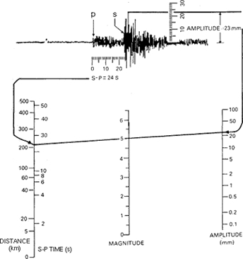
The Richter scale (or Richter magnitude scale or local magnitude [ML]) scale) is a measure of the magnitude of (or more specificifically the energy released by) an earthquake that is determined from the logarithm of the amplitude of waves recorded on a seismogram at a certain period.
The Richter magnitude scale was developed in 1935 by Charles F. Richter of the California Institute of Technology as the "local magnitude" or ML scale for moderate-size (3 < ML < 7) earthquakes in southern California. The ML scale is often called the “Richter scale” by the press and the public. Fundamentally, it is a mathematical way to compare the size of earthquakes.
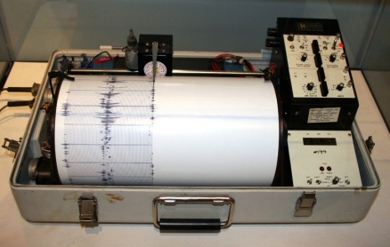
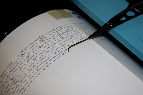
The magnitude of an earthquake is determined from the logarithm of the amplitude of waves recorded by seismographs. Adjustments are included for the variation in the distance between the various seismographs and the epicenter of the earthquake. On the Richter Scale, magnitude is expressed in whole numbers and decimal fractions. For example, a magnitude 5.3 might be computed for a moderate earthquake, and a strong earthquake might be rated as magnitude 6.3. Because of the logarithmic basis of the scale, each whole number increase in magnitude represents a tenfold increase in measured amplitude. As an estimate of energy, each whole number step in the scale corresponds to the release of about 31 times more energy than the amount associated with the preceding value.
At first, the Richter Scale could only be applied to the records from instruments of identical manufacture. Now, instruments are carefully calibrated with respect to each other. Thus, magnitude can be computed from the record of any calibrated seismograph.
Contents
Richter Scale Magnitudes and Earthquakes
- Earthquakes with magnitude of about 2.0 or less are usually called microearthquakes. They are not commonly felt by people and are generally recorded only on local seismographs.
- Events with magnitudes of about 4.5 or greater - there are several thousand such shocks annually - are strong enough to be recorded by sensitive seismographs all over the world.
- Great earthquakes, such as the 1964 Good Friday earthquake in Alaska, have magnitudes of 8.0 or higher. On the average, one earthquake of this size occurs somewhere in the world each year.
The Richter Scale has no upper limit.
Recently, another scale called the moment magnitude scale has been devised for more precise study of great earthquakes.

Additional and Alternative Earthquake Measurements
The Richter (local) magnitude scale (ML) is not the only method for measuring earthquake magnitude. Different methods of estimating magnitude are used, depending upon the time elapsed since the earthquake’s occurrence. Several scales have been defined, but the most commonly used are:
- local magnitude (ML), commonly referred to as "Richter magnitude";
- surface-wave magnitude (Ms);
- body-wave magnitude (Mb); and,
- moment magnitude (Mw).
The first three scales have limited range and applicability and do not satisfactorily measure the size of the largest earthquakes (M >= 7). Also, Richter's original methodology was not designed to use data from earthquakes recorded at epicentral distances greater than about 600 km.
The moment magnitude (Mw) scale, based on the concept of seismic moment, is uniformly applicable to all sizes of earthquakes but is more difficult to compute than the other types. For historical earthquakes, the preferred magnitude will be the best estimate of the moment magnitude (and is used in the table below). This estimate, however, is not simply a conversion from some other historical magnitude scale, but an estimate obtained using supplementary information (ground rupture, macroseismic data, etc.).
All magnitude scales should yield approximately the same value for any given earthquake.
Another important measures of earthquakes is duration magnitude mD.
The least complicated, and probably most accurate, terminology is to just use the term “magnitude” and to use the symbol M (i.e., a capital M, plain text, without any subscripts or superscripts). M should is typically expressed to the nearest 0.1.
Richter Scale Magnitude and Damage
The Richter scale is not used to express damage. An earthquake in a densely populated area which results in many deaths and considerable damage may have the same magnitude as a shock in a remote area that does nothing more than frighten the wildlife. Large-magnitude earthquakes that occur beneath the oceans may not even be felt by humans.
The effect of an earthquake on the Earth's surface is called the intensity. The intensity scale consists of a series of certain key responses such as people awakening, movement of furniture, damage to chimneys, and finally--total destruction. Although numerous intensity scales have been developed over the last several hundred years to evaluate the effects of earthquakes, the one currently used in the United States is the Modified Mercalli (MM) Intensity Scale. It was developed in 1931 by the American seismologists Harry Wood and Frank Neumann. This scale, composed of 12 increasing levels of intensity that range from imperceptible shaking to catastrophic destruction, is designated by Roman numerals. It does not have a mathematical basis; instead it is an arbitrary ranking based on observed effects.
The Modified Mercalli Intensity value assigned to a specific site after an earthquake has a more meaningful measure of severity to the nonscientist than the magnitude because intensity refers to the effects actually experienced at that place. After the occurrence of widely-felt earthquakes, the Geological Survey mails questionnaires to postmasters in the disturbed area requesting the information so that intensity values can be assigned. The results of this postal canvass and information furnished by other sources are used to assign an intensity value, and to compile isoseismal maps that show the extent of various levels of intensity within the felt area. The maximum observed intensity generally occurs near the epicenter.
The lower numbers of the intensity scale generally deal with the manner in which the earthquake is felt by people. The higher numbers of the scale are based on observed structural damage.
| Date |
Location |
Fatalities | Magnitude |
| January 23, 1556 |
Shensi, China |
830,000 | ~8 |
| August 17, 1668 |
Anatolia, Turkey |
~8,000 | ~8 |
| November 1, 1755 |
Lisbon, Portugal |
70,000 | ~8.7 |
| December 16, 1857 |
Naples, Italy |
11,000 | ~6.9 |
| October 27, 1891 |
Mino-Owari, Japan |
7,273 | ~8 |
| June 15, 1896 |
Sanriku, Japan |
27,000 | ~8.5 |
| April 18, 1906 |
San Francisco, CA |
3,000 | 7.8 |
| August 17, 1906 |
Valparaiso, Chile |
3,882 | 8.2 |
| December 28, 1908 |
Messina, Italy |
70,000 | 7.2 |
| December 16, 1920 |
Ningxia-Gansu, China |
200,000 | 7.8 |
| September 1, 1923 |
Kanto, Japan |
143,000 | 7.9 |
| May 22, 1927 |
Gansu, China |
>40,900 | 7.6 |
| January 13, 1934 |
Bihar, India |
10,700 | 8.1 |
| December 26, 1939 |
Erzincan, Turkey |
32,700 | 7.8 |
| February 29, 1960 |
Agadir, Morocco |
10,000 | 5.7 |
| May 22, 1960 |
Chile |
1,655 | 9.5 |
| March 28, 1964 |
Prince William Sound, AK |
128 | 9.2 |
| May 31, 1970 |
Peru |
66,000 | 7.9 |
| July 27, 1976 |
Tangshan, China |
255,000* | 7.5 |
| September 19, 1985 |
Michoacan, Mexico |
9,500 | 8 |
| December 7, 1988 |
Spitak, Armenia |
25,000 | 6.8 |
| August 17, 1999 |
Izmit, Turkey |
17,118 | 7.6 |
| January 26, 2001 |
Gujarat, India |
20,085 | 7.6 |
| December 26, 2003 |
Southeastern Iran |
31,000 | 6.6 |
| December 26, 2004 |
Off west coast northern Sumatra |
227,898 | 9.1 |
| October 8, 2005 |
Pakistan |
86,000 | 7.6 |
| May 26, 2006 |
Java, Indonesia |
5,749 | 6.3 |
| May 12, 2008 |
Eastern Sichuan, China |
87,587 | 7.9 |
| January 12, 2010 |
Near Port-au-Prince, Haiti |
222,570 | 7.0 |
| March 11, 2011 |
Pacific Ocean, East of Oshika Peninsula, Japan |
-TBD- | 8.9-9.1 |
- Fatalities in the 1976 Tangshan, China earthquake were estimated as high as 655,000.
Source: Preferred Magnitudes of Selected Significant Earthquakes, USGS, 2010 (with additions on two most recent major earthquakes in Haiti and Japan.

