Red River, Texas
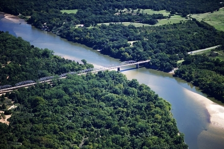
Red River Basin, southwestern USA. Source: NASA/cc-3.0
The Red River, sometimes called the Red River of the South, is a major tributary of the Mississippi River; the Red River, which rises in eastern New Mexico, drains a large portion of north Texas, as well as part of southern Oklahoma, southwest Arkansas and northern Louisiana, in the USA. There are basin water quality issues of salinity stemming from the presence of saline springs in the headwaters, and from elevated coliform bacteria levels in the middle to lower part of the catchment. There is a low level of faunal endemism in the basin; however, as a transition between eastern and western parts of the USA, the Red River Basin is a frequent east-west species range limit demarcation.
Recently the Zebra Mussel (Dreissena polymorpha), an introduced species to the Red River, has been recognized in Lake Texoma, an artificial impoundment of the river, as a significant threat to the aquatic ecosystem. As of 2012 authorities, in Texas have begun to take action to effect control of this alien species. Terrestrial elements of ecosystems through which the Red River flows vary dramatically from a semi-arid headwaters grassland to swampy zones of the Piney forests ecoregion in the lower basin.
Contents
Basin geometry
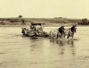 Historic photo of Red River crossing near Granite, OK. Source: NOAA To the north of the Red River Basin is the Arkansas River Basin, while to the south are a series of coastal basins that drain to the Gulf of Mexico. West of the Red River Basin. all basins drain toward the Gulf of California and the Pacific Ocean. The headwaters of the Red River occur in two forks in Oklahoma and Texas on the Llano Estacado Mesa, the chief one being Prairie Dog Town Fork rising in north Texas. This headwaters reach occurs within the Western short grasslands ecoregion.
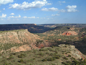 Palo Duro Canyon State Park. Source; CC-3.0 Prior to the confluence of the two forks, the Red River cuts through the Palo Duro Canyon, the second largest canyon landform in the USA. This complex system of hoodoos and canyons was originally downcut during the Pleistocene as the Llano Estacado was uplifted. The Prairie Dog Town Fork plunges down the Caprock Escarpment to join the north fork and roll through Wichita Falls, Texas. After falling from the escarpment, the Red River flows through the Central and Southern mixed grasslands and the Central forests grasslands of the middle basin.
The lower reaches of the Red River include travel through east Texas, a small area of southwestern Arkansas and a portion of northwest Louisiana. In this lower basin the channel is often over 1000 feet wide, traversing erosive soils, subjecting the river to a shifting channel alignment; moreover, at flood stage the channel width often exceeds one mile.
The Red River discharges to the Mississippi River immediately above the branching of the branching of the Atchafalaya River distributary; the Atchafalaya is a river which is assuming dominance as the future main branch of the Mississippi River through natural hydrologic change; moreover, the Atchafalaya is expected to take over most of the discharge flow of the Mississippi, unless human intervention is continued in waterway dredging to salvage the future of New Orleans as a major port. The terrestrial ecoregions in this lower basin include Piney forests and Mississippi lowland forests.
Water quality
Chief water quality issues in the Red River Basin include salinity, bacteria levels and dissolved oxygen. The salinity issues derive from presence of dissolved chloride and sulfate ions. The chief origin of elevated concentrations of these constituents are salt springs in the western headwaters portion of the basin, which in some reaches have salinities higher than that of seawater. In fact, in some places side pooling where high evaporation occurs can lead to formation of hypersaline ponds.
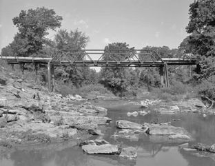 Choctaw Creek, Denison, Texas. Source: Joseph E.Elliot/Library of Congress Bacteria concentrations have mainly been tracked utilizing Escherichia coli densities also are used to assess the quality of recreational waters. The natural habitat of E. coli is solely the intestinal tracts of warm-blooded animals, although the bacterium can survive ex vivo in natural water systems such as rivers. The presence of E. coli in water samples of the lower Red River Basin is an indicator of fecal water pollution and the potential presence of an enteric pathogen. Some of the waters of the lower reach constitute a risk to human health with respect to contact events such as swimming or wading. Example sites of such risk are near tributaries Mineral Creek and Choctaw Creek. Likely sources of coliform contamination are livestock grazing at densities greater than desirable.
Dissolved oxygen concentrations in the Red River are generally viewed as acceptable, based upon limited amounts of data collected (chiefly in the middle reach areas of Index and Arthur City); however, as in other areas of the western USA, dissolved oxygen is typically most critical in summer months when water temperatures are high (thus holding minimal quantities of oxygen), and metabolic needs of aquatic fauna are greatest.
Basin fishes
One of the most notable fishes present in the Red River is the 1.3 meter long Mississippi Paddlefish (Polyodon spathula, VU), which taxon prefers deeper areas of slow flowing rivers such as the lower basin of the Red River. The Spotted Bass (Micropterus punctulatus), a popular sport fish, is found widely in the Mississippi River Basin as well as other coastal Gulf of Mexico drainages within Texas. Another even more widely distributed sportfish that can be found in the Red River is the White Crappie (Pomoxis annularis). The Blue Catfish (Ictalurus furcatus) is found in the middle and lower parts of the Red River Basin, and this species is also sought by anglers.
Basin terrestrial vegetation
In the headwaters rough terrain area the Western short grasslands predominate. This grassland ecoregion is distinguished from other grassland units by low rainfall, relatively long growing seasons, and warm temperatures. From a structural standpoint, the short stature of the dominant sod-forming grasses, Needle Grama (Bouteloua aristidoides) and Buffalo Grass (Buchloe dactyloides), separate the ecoregion from other units. Low rainfall prohibit useful crop growing, although some grazing uses are carried out.
The infamous dustbowl of the 1930s was centered in this western part of the Red River Basin. After the desertification that followed the misguided attempts at crop growth from the early 20th century, large areas have been invaded by Honey Mesquite (Prosopis glandulosa) and thorny shrubs, e.g. Opuntia spp., Lotebush (Zizyphus obtusifolia), Berberis trifoliata, forming a savanna or shrubland with a shortgrass prairie understory.
Basin amphibians
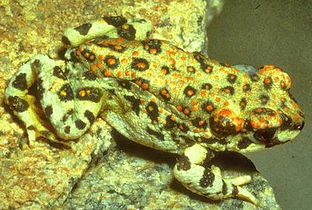 Red-spotted Toad. Source: John Tashjian/EoL Amphibians in the Red River Basin include the Red-spotted Toad (Anaxyrus punctatus), which can be seen in the upper basin of west Texas; the Couch's Spadefoot Toad (Scaphiopus couchii), which is found in the upper and middle basin; the Great Plains Narrowmouth Toad (Gastrophryne olivacea). The Eastern Green Toad (Anaxyrus debilis) and Southern Spadefoot Toad (Spea multiplicata) both occur in arid upper and middle reaches, and witnesses its eastern and northern range limits in the Red River Basin.
The very wide ranging Northern Cricket Frog (Acris crepitans) can be found throughout the basin and broadly beyond. The Plains Leopard Frog (Acris crepitans) is also found throughout the basin and the Red River basin comprises a portion of the southern species range limit. Cope's Gray Treefrog (Hyla chrysoscelis) is found in the lower woods in such places as the bayous and ponded prairies of the Piney Woods. Also inhabiting the swampy Piney Woods is the Southern Crawfish Frog (Lithobates areolatus), which is a fossorial anuran that takes over rodent, crayfish or reptile burrows.
Basin reptiles
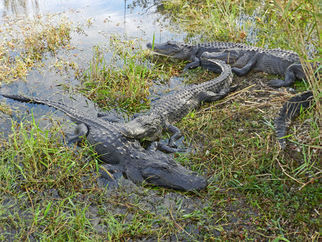 American Alligators in the wild. @ C.Michael Hogan The Red River Basin is home to a number of reptiles, including the Black-necked Garter Snake (Thamnophis cyrtopsis) in the upper basin, residing in the eastern Limit of the species range. The Collared Lizard (Crotaphytus collaris) occurs in most of the Red River Basin. The small Flat-headed Snake (Tantilla gracilis) is found in the upper and most of the lower Red River Basin as well as northward extent into the Arkansas River Basin and southwestward to northern Mexico. The Four-lined Skink (Plestiodon tetragrammus) occurs in the upper half of the Red River Basin, extending southward to northeastern Mexico. Greater Earless Lizard (Cophosaurus texanus) is found in the upper and middle Red River Basin, which occurrences mark the northern and eastern range limits of this taxon. The lower basin provides habitat for reptiles who seek more aquatic habitat in the swampy bayous and braided channels in the Piney forests; perhaps the most notable reptile in this zone is the American Alligator (Alligator mississippiensis).
Basin mammals
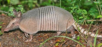 Nine-banded Armadillo. Source: Encyclopedia of Life A number of mammalian species are found in the Red River [catchment] area, including the Banner-tailed Kangaroo Rat (Dipodomys spectabilis, NT), whose occurrence is evident in the upper Red River Basin. The Nine-banded Armadillo (Dasypus novemcinctus) is a notable widely occurring member of the dasypodidae family found in the upper and middle basin, whose historic northern range limit was the Red River Basin, but is now found north to the Arkansas River Basin.
Bovids found in the headwaters area include the Bighorn Sheep (Ovis canadensis) and the Pronghorn (Antilocapra americana), the western Red River Basin comprising part of the eastern [[species range limit]s] for these two grazers. Mountain Lion (Puma concolor) occurs in the western portion of the Red River Basin, and this locus marks part of the eastern range limit of this apex predator, save for an outlier relict population in the Everglades of Florida. The Collared Peccary (Tayassu tajacu) is near the eastern limit of its broad range in the basin here. The Desert Shrew (Scaphiopus couchii) is found in more arid parts of the basin and has a range extending westward to southern California and southwestward to Mexico.
Ancient history
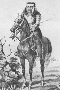 Warrior of the Lipan Apache tribe, who had conflict with Comanches. Source: Arthur Schott 1857 A number of diverse Native American tribes inhabited the Red River Valley throughout prehistory. At the time of initial European exploration of the Red River Basin, the eastern portion of the Piney Woods ecoregion were inhabited by South Caddo tribes, who captured abundant fish and terrestrial wildlife, and furthermore raised crops; the Caddoan culture is thought to have controlled this portion of the watershed for several thousand years.
The Lipan Apache dominated the western Red River basin until well after initial European contact; then in the 1700s invading Comanche from the north pushed the Apaches from their traditional lands. The middle basin was governed by Wichita and Tonkawa tribes, who constructed temporary tepees or thatched rectangular huts upon the prairie, and undertook some farming; however, deriving from at least as early as 500 BC, they mostly pursued game in nomadic seasonal fashion until around 900 AD, when farming villages became common. In the 1800s the Tonkawa were allied with the Texas Rangers in conflict with the Comanche tribe.
References
- Stanley Baldys III and D.G. Phillips. 1998. Stream monitoring and educational program in the Red River Basin, Texas, 1996–97: U.S. Geological Survey Fact Sheet 170–97
- Arthur Benke and Colbert Cushing. 2005. Rivers of North America. Academic Press. p.1144. ISBN0-12-088253-1
- G.M. Brune. 1981. Springs of Texas. Fort Worth, TX: Branch-Smith
- Vine J. Deloria Jr. and Raymond J. DeMaille. 1999. Documents of American Indian Diplomacy Treaties, Agreements, and Conventions, 1775-1979. University of Oklahoma Press.ISBN978-0-8061-3118-4.
- D.L. Flores. 1984. The Ecology of the Red River in 1806. The Southwestern Historical Quarterly 88,1
- Lawrence J. Rouse, Harry H. Robert, and Robert H.W. Cunningham. 1978. Satellite Observation of the Subaerial Growth of the Atchafalaya Delta, Louisiana. Geology 6 (7): 405–408
- Karl H. Schleser. 1994. Plains Indians, A.D. 500 to 1500: The Archaeological Past of Historic Groups. University of Oklahoma Press, Norman, Oklahoma
- Darwin Spearing. Roadside Geology of Texas. Missoula, Montana. Mountain Press Publishing Co., 1991. ISBN 0-87842-265-X
- U.S. Geological Survey. 2003. Red River Fact Sheet 106-03. USGS and Red River Authority of Texas