Rainforests of the Atsinanana, Madagascar
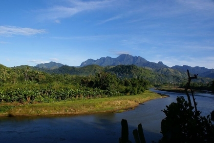
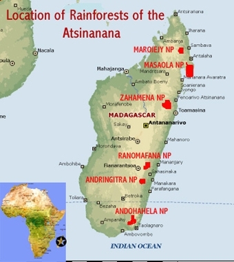
The rainforests of the Atsinanana are comprised of six national parks along the 1,600 kilometre length of eastern Madagascar represent the relics of northern, central and southern rainforests critically important for maintaining the ecological processes necessary for the survival of Madagascar's unique biodiversity.
They display notable examples of evolving ecological systems in an area which for 60 million years has developed in isolation. Some of the world’s most diverse, rare and threatened biological communities. 2,598 species in 166 families and 1,039 genera, 97 of which are endemic, are found there. They contain two-thirds of the island’s mammals and 25 species of lemur, many now threatened by continued hunting.
Threats to the site: The integrity of Masoala and Marojejy parks is threatened by the illegal logging of endemic rosewoods and ebony, subsequently exported under government license, and in the depleted woods, by lemur hunting for bushmeat to feed the thousands attracted to the forest for profit.
Contents
- 1 Geographical Location
- 2 Biogeographical Provinces
- 3 Dates and History of Establishment
- 4 Land Tenure
- 5 Areas
- 6 Altitude
- 7 Physical Features
- 8 Climate
- 9 Vegetation
- 10 Fauna
- 11 Cultural Heritage
- 12 Local Human Population
- 13 Visitors and Visitor Facilities
- 14 Scientific Research and Facilities
- 15 Conservation Value
- 16 Conservation Management
- 17 Management Constraints
- 18 Comparison with Similar Sites
- 19 Staff
- 20 Budget
- 21 Local Addresses
- 22 Further Reading
Geographical Location
These six forested national parks are sited at intervals along the foot, eastern slopes and plateau escarpment edge of the highlands which extend 1,600 kilometers (km) down the length of eastern Madagascar. They rise from sea level to over 2,200 meters and the distance between Marojejy in the north and Andohahela in the south is 1,200 km, or nearly eleven degrees of latitude (15°00’ to 25°30’S).
Biogeographical Provinces
- Malagasy Rainforest (3.3.1)
- Malagasy Woodland/Savanna (3.9.4)
- Malagasy Thorn Forest (3.10.4)
Dates and History of Establishment
| 1927 | A network of 12 Natural Reserves set up; |
| 1958 | National Parks established by government decree; |
| 1960s | 23 special Reserves established, the last in 1985 after the first consultations with local people; |
| 1964 | Masoala National Park declassified to allow commercial logging; |
| 1970 | Government funding severely reduced; foreign visitors denied access; |
| 1985 | Protected Area system re-opened to foreign scientists and organisations after 15 years; |
| 1990 | The Malagasy Environmental Charter decreed; strengthened in 1997; |
| 1991 | National Environmental Action Plan launched, the first of three five-year Environmental Programmes started; |
| 1997-9 | The nominated National Parks created from existing Nature Reserves; |
| 1997 | Most of the six sites came under the management of ANGAP (l’Association Nationale pour le Gestion des Aires Protégées, later Parcs Nationales Malagasy (PNM-ANGAP); |
| 2001 | The national Protected Area Management Code adopted; |
| 2007 | Inscribed on the World Heritage List under Natural Criteria ix and x. |
| 2010 | Listed as a World Heritage site in Danger because of illegal logging and hunting of rare lemurs. |
Land Tenure
State. Administered by the National Parks of Madagascar — National Association for the Management of Protected Areas (PNM-ANGAP), under the Ministry for the Environment, Waters and Forests.
Areas
The existing total area of the six sites is 479,660.5 ha (Nomination document, 2007). Each site has a 2.5 km buffer zone, the area of which is excluded from the totals given.
| Protected Area |
Region |
Centrepoint |
Area (ha) |
|
Parc Nationale de Marojejy (6 subsites) |
Sava |
E: 48 o 43’30” S: 17 o 37'45" |
59,751.8 |
|
Parc Nationale de Masoala |
Sava – Analanjirofo |
E: 47 o 15’00” S: 21 o 8’ 24" |
212,886. |
|
Parc Nationale de Zahamena |
Alaotra – Mangoro - Analanjirofo – Atsinanana |
E: 47 o 15’00” S:17 o 37'45" |
69,898.5 |
|
Parc Nationale de D'Andringitra (3 subsites) |
Vatavavy – Fitovinany - Haute Matsiatra |
E: 47 o 15’00” E: 47 o 15’00” |
40,500.0 |
|
Parc Nationale de D'Andringitra |
Ihorombe - H'te Matsiatr |
E: 46 o 55’44” S: 22 o 13’22” |
32,074.5 |
|
Parc Nationale de D'Andohahela |
Anosy |
E: 47 o 09’52” S: 24 o 45’10” |
64,547.0 |
Altitude
Under sea level (Masoala N.P) to 2,658 meters (Pic Boby in Andringitra N.P.).
Physical Features
Madagascar is 1,650 km in length from north to south, dominated above approximately 1,300 m by a fertile central plateau over which rise mountains of 2,000 m and higher. On the east, the plateau edge falls steeply from the Betsisimana escarpment to a fairly narrow coastal plain, the slopes being largely rainforested. This is a belt now some 15 to >50 km wide along 1,400 km of mountainsides between about 600-800 m and 1,200 m where nearly all of the nominated parks are sited. ‘Atsinanana’ defines this linear ecoregion of eastern montane rainforest, but the nominated area also includes some vulnerable lowland forest at sea level, and some montane areas over 1,900 m high.
Three mountain massifs are more prominent: the Massif de Marojejy-Tsaratatana-Mangaro in the north, the Massifs de l’Ankaratia and Andringitra 900 km south, and the Anosyenne range at the southern end of the island. Most of the region is underlain by Pre-Cambrian metamorphic and igneous rocks and its soils, except on flatter lowlands, are thin and nutrient-poor. The northeastern lowland to montane rainforests are represented by Marojejy and Masoala National Parks, and the coastal forest by Masoala, 130 km south of Marojejy; the north-central lowland to mid-level rainforests (with some montane and swamp forests) are represented by Zahamena, 370 km south of Marojejy; the south-central lowland to high-level rainforests (also with montane and swamp forests). by Ranomafana and Andringitra Parks, 800 and 900 km south of Marojejy; the southern lowland to mid-level rainforests and some savanna are represented in Andohahela Park 1,200 km south.
Marojejy is largely a sculpted granite massif with sharp peaks rising to 2,132 m above narrow valleys and extensive lowland, mid-level and montane forests. It has a diversity of high-level habitats, with many microclimatic variations. Its uplands, as with all the other sites, are the source of many steep streams and rivers important to surrounding farmlands. As with most of the other sites, its soils are red-yellow and ferralitic, and in the mountains, sandy and infertile lithosols.
Masoala is Madagascar’s largest protected area and its most important for endemic species, with wide expanses of lowland and coastal forests. The uneven topography is divided between the granite backbone of the Masoala peninsula, reaching to 1,000 m, parallel ranges of lower hills inland, and a lowland beside the wide Bay of Antongil of marshes with hydromorphic soils, three to five meter high dunes, and cultivated alluvial plains. The Park has three small outliers of coastal forest in the east with sandy and rocky beaches, and a marine site with coral reefs at Tambolo on the west of the peninsula.
Zahamena has broken undulating terrain on gneiss, quartzite and amphibolite basement rocks and very little flat land. Its 400 to 1,600 m altitudinal range covers a wide range of habitats.
Ranomafana is a composite of three subsites in a very dissected hilly landscape with marshes, formerly rice paddies, hot springs and narrow steepsided valleys. Its soils are ferralitic, generally acidic, infertile and erodible except on lower slopes.
Andringitra lies on a very ancient gneiss and granite plateau. Half is open grassland with giant granite domes, sharp ridges, narrow valleys, gorges and mountains where the climate is temperate; Pic Boby (2,658 m) and Pic Bory (2,630 m) are the highest peaks. This spectacular massif is flanked by steep slopes except to the south.
Andohahela comprises three different ecosystems: rainforests at varying levels, a montane area, and a fringe of open wooded savanna on its western foothill edge. Folded basement schists are penetrated by the granite ridges of the Anosyenne mountains which form a barrier between the east coast and the lands in their rain shadow. The mountains, with escarpment-enclosed valleys, reach to 1,972 m, and have acid ferralitic clays. To their west are dry ferruginous soils covered by open woodland and savanna. The combination of different altitudes, climates and soils, create the great ecological variety of this site.
Climate
The climate on the eastern coast and mountains which run the length of the country is humid tropical, becoming sub-humid and even temperate at high levels, and varying locally with latitude and topography. Freezing can be experienced in the mountain sites, and snow has fallen on Andringitra. In the north, diurnal temperature ranges can exceed the annual range. In summer the plateau edge temperature averages 19 degrees C and in winter 16 degrees Celsius (C). The lowland forests are five to six degrees warmer, averaging about 26 degrees C in summer and 18 degrees C in winter. Rainfall is often heavy, decreasing from north to south and from east to west of the island. It is highest during the summer monsoon and least during the cooler winters. Marojejy in the north receives nearly 2,000 millimeters (mm), the annual average for the sites, but Masoala in the cyclone-prone coastal lowlands, can receive over 6,000 mm, and the highlands are up to 500m wetter than the average slope. Summer rainfall in the central sites often comes in the form of continuous drizzle. Andohahela in the far south has 1,500-2,000 mm on its wet eastern side but 600-700 mm in its rain-shadowed east, which is just within the subtropical high-pressure belt. During the summer monsoon between November and March the prevailing northeasterly trade winds from the ocean are often displaced by cyclones. Historically, the prevailing easterlies have reduced the influence of African air- and water-borne life on the island.
Vegetation
The Indo-Madagascar continent began to separate from Gondwanaland about 165 million years ago, and India from mainland Africa beginning about 70 million years ago (EAZA,2006). Madagascar’s flora and fauna evolved in isolation from Africa for at least 40 million years, and are uniquely endemic as a result. Its species record the region’s phytogeographic relation to the floras of Malaya, India and Australia. It is an evolutionary laboratory of taxonomic groups and ecological communities that have disappeared elsewhere in the world. Species from the past Pleistocene refuges in the mountains, repopulated lower slopes between barrier rivers. The speciation and adaptive radiation resulting from this combination of topographic and climatic isolation have made this the world’s third most biodiverse region after the tropical Andes and Sundaland. Of 13-14,000 species of all groups for the whole country, 85% are endemic (Goodman & Benstead, 2003).
The region is the world’s second centre of dispersal for the Bignoniaceae; it has over 200 species of Rubiaceae in seven genera; and 170 species of palms in the Aracaceae. Since over 90% of the more accessible original forest has been destroyed, much of the remaining diversity is concentrated in the range of habitats on the mountain slopes between the coast and the central plateau. The differences in altitude, latitude, climate, topography, bedrock types and soils are greatest in this combination of dense rainforest and highland. The number of Madagascar’s threatened species is so great that the following summaries name in full only the 22 globally critically endangered and endangered species listed in the 2006 IUCN Red list. In the six sites some 2,598 Madagascan species have so far been inventoried, in 166 families and 1,039 genera where 5 of the 6 endemic families and 97 of 209 endemic genera are represented.
The principal rainforest types of Antsinanana are:
- Coastal rainforest to 400m, represented in Masoala NP (approximately eight % of the total nominated area);
- Dense lowland rain forest between 400 and 600-800 m depending on locality, in Marojejy, Masoala, Zahamena, Befotaka-Midongy and Andohahela Parks (about 18.5% of the total);
- Dense mid-level grading to montane rainforest between 800 and 1,300 m, found in all the parks (approximately 48% of the total);
- Lower sclerophyllous montane forest between 1,300 and 2,000 m, in Marojejy, Andringitra and Andohahela Parks (approximately 5.5% of the total);
- With ericoid montane thickets on summits above 1,800-2,000 m, also in Marojejy, Andringitra and Andohahela Parks.
There is a little transitional and dry forest in Andohahela and small areas of swamp vegetation in Ranomafana. With altitude and its cooler and wetter climate the canopy height is lower, becomes less stratified and harbors more epiphytes, bryophytes and lichens; the herb layer is also richer. The coastal forest, being accessible and protected only in parts, is the most threatened by encroachment. The lowland forest is the most diverse but is under-represented and also much threatened by encroachment. The mid-level forest is well represented but a little less vulnerable to the same pressures. The montane rainforests where pandanus and bamboo flourish, and the open grazed areas, are subject to fires as well as encroachment. The other vegetation types are rarer but often not well conserved.
Marojejy is 92% dense rainforest, the only large massif in Madagascar where most of the forest remains intact. It may in the past have been a climatic refugium. Its three main ecosystems are dense evergreen lowland rainforest, much of it secondary, dense mid-level rainforest and dense stunted montane forest (in this case, cloud forest), a pattern typical of nearly all the sites. Above about 2,000 m there is a well-preserved area of ericoid montane bush with some peat bogs. The lowland forest is formed predominantly of species of Dalbergia, Diospyros, Ocotea, Symphonia and Tambourissa, with giant bamboo Ochlandra sp.,Albizia, Brochoneura acuminata and 25-30 m emergents of Canarium sp. It has more than 50 species of palms, six being endemic, and 305 species of fern, six also endemic.
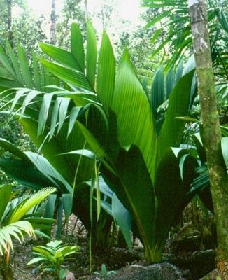
| Marojejya darianii. Source: Floribunda Palms |
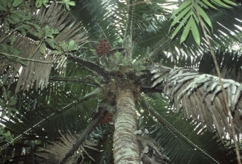
| Voanioala gerardi. Source: virtualherbarium.org |
Masoala is also one of the largest remaining natural forests in the country, very rich in globally threatened species. It covers two-thirds of the Masoala peninsula which alone has 2,000 species. Its dense lowland rainforest is the largest remaining in the country and grades continuously from coastal and flooded lowland forests to over 1,200m. This forest is the most biodiverse with over 1,100 species of plants in 100 families and 400 genera. Its emergent trees can reach 50m. 15 out of 20 species of the island’s palms are found only there. 155 pteridophytes in 50 genera comprise 27% of Madagascar’s ferns and it is a centre for their dispersal. Among the endangered palms are Leptolena masaoalensis (CR), Marojejya darianii (CR), Voanioala gerardi (CR), Asteropeia multiflora (EN), A. matrambody (EN), A. rhopaloides (EN), Lemurophoenix halleuxii (EN); the pitcher plant Nepenthes masaoalensis (EN) also grows there. Even the disturbed coastal forests have 394 species, including many rare salt– and cyclone-tolerant trees and seven species of mangrove (Madagascar mangroves). The marine reserve has coral reef and many species of alga.
The two dominant ecosystems of Zahamena are the dense evergreen forest, lowland, mid-level and high-level, to 1,200m; and its streams and marshes. The highest vegetation includes montane sclerophylls, ericaceous brush and grassy savanna. Nearly all the evergreen woody plants of Madagascar grow there: 511 species, 85% being endemic, 151 pteridophytes, 60 orchids, 22 palms and 10 pandanus species. The lowland forest is dominated by species of Tambourissa, Weinmannia, Diospyros, Ravensara and Dalbergia. The montane forest is dominated by Podocarpaceae, Cunoniaceae and Pandanaceae and the thickets by tree ferns Cyathea spp., Asteraceae, Ericaceae, Podocarpaceae, Rhamnaceae and Rubiaceae. The palms include Asteropeia multiflora (EN), A. rhopaloides (EN) and Leptolaena abrahami (EN).
Ranomafana is also predominantly dense lowland, mid-level and sclerophyllous forest with bamboo between 1.200-1,300m, part of a much fragmented and degraded central plateau vegetation. Both the bamboo and the lowland forest are being encroached on. There is also an area of flooded valleys and swamp forest, coveted for rice cultivation, containing rare species including Leptolaena abrahami (EN).
Andringitra, owing to its altitudinal range, has highly diverse habitats: dense lowland forest, and mid-level rainforest dominated by species of Podocarpus, Weinmannia, Pandanus and tree ferns Cyathea. It is rich in orchids, bryophytes, lichens, ferns and palms, including Asteropeia amblyocarpa (CR) and A. labatii (EN). At high-level are Podocarpus, stunted sclerophyll forests, dry river-bank xerophytes, dense ericaceous and myrtillaceous bush with many orchids and some peatbogs, shrubby prairies and high-grass savanna. The prairies are dense grassland with sedges and semi-woody herbs, maintained in the past by fire to improve the grazing. Rocky area vegetation includes species of Philippia, Aloe, Pachypodium, Kalanchoe and Liliaceae.
With Andohahela the many habitats and the extreme contrast between the wet and dry sides of the Park, with the transition between them, make the site of great scientific interest. Dense lowland, mid-level and high-level rainforests characterise the humid slopes, dominated by Tambourissa, Symphonia and Dalbergia spp. The palm Asteropeia amblyocarpa (CR) occurs, also tree ferns Cyathea spp and orchids. The drier slopes and small area of lower land on limestone and laterite to the west is spiny bush, dominated by savanna with drought-adapted plants.
Fauna
Madagascar is among the world’s most important areas for rare fauna, which is as singular as its flora. The six rainforest sites range through 10 degrees of latitude and 2,500 metres of altitude connected by habitats held largely by the Forest Service. This allows for the migration of animals along the 1,400 km forest belt. The 6 sites provide a series of protected sites along this belt which might be linked in future. Among the country’s 162 endemic families, the six sites contain five primate, sixplant and five bird families, one rodent, one carnivore, one bat, one amphibian and one fish family. Species richness decreases with altitude, especially in the montane thicket zone. There are most rodents and insectivores in the mid-levels.
Mammals: Many animals disappeared after man’s arrival some 2,500 years ago and the island no longer has large herbivores or carnivores though it does harbor 101 terrestrial mammals, nearly all endemic, and the world’s largest number of endangered primates. 74 of the country’s 155 endemic species (excluding bats) have been found in the six sites, 28 being on the 2006 global Red list and 12 which are known only from a particular protected area. These include 28 species of lemurs in five endemic families, which total a quarter of the world’s primate species. 19 of these are unique to the six sites. These also harbor nine small native carnivores, 17 species of rodents and 23 species of shrew-like tenrecs. Country-wide there are at least 300 species of amphibians, 90% being endemic and 346 species of reptiles, also 90% endemic. 150 endemic species of amphibians and reptiles have been recorded in the six sites. 140 species of fish, 93 being endemic, are found mostly in the eastern highland and lowland rainforests and nowhere else. 173 species of birds have been reported for the 6 rainforest sites, three families and 45 species being endemic, 18 red-listed. This is 83% of the breeding population of 209 species, 61% of the 283 total. Zahamena is especially rich because of its range of altitudes and habitats. Totals of three animal classes are listed below:
|
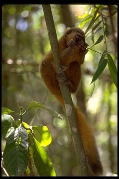
| Golden Bamboo Lemur. Source: Gerald and Buff Corsi |
|
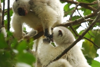
Silky Sifak/Silky Lemur. Source: Simponafotsy |
|
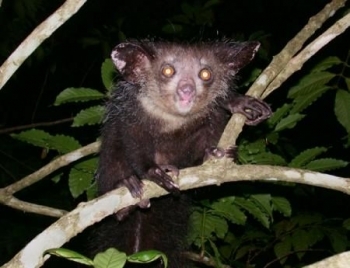
Aye-aye (Daubentonia madagascariensis) Source:T. Junek |
Marojejy has an exceptionally rich herpetofauna, 33% of the country’s total. 20 of its 74 amphibians and 28 of its 73 reptiles are found in no other park, as are four of its mammals. Among its 36 mammal species are 10 lemurs, including the golden and greater bamboo lemurs Hapalemur aureus (CR) and H. simus (CR), the silky lemur Propithecus candidus (EN), the aye-aye Daubentonia madagascariensis (EN) and the hairy-eared dwarf lemur Alloceba trichotis (EN). Another endangered animal is a large cat-like viverrid, the Malagasy civet or fossa Cryptoprocta ferox (EN). One rare rodent Voalavo gymnocaudus, is endemic to the mountain. Among 96 species of birds of which 63 are endemic, are the recently rediscovered Madagascar serpent-eagle Eutriorchis astur (EN) and Madagascar red owl Tyto soumagnei (EN). In all, 52 species are unique to Marojejy.
Masoala, with its large area and marine parks, holds over 50% of Madagascar’s animal species and is the only one of these sites large enough to ensure the long-term viability of its wildlife populations. Its 38 mammals include 13 species of lemur, seven carnivores (six being endemic), nine rodents, including the Malagasy mongoose Eupleres goudotii (EN), 10 insectivores,14 bats, and several cetaceans. Four species do not occur elsewhere in the six sites. Among the lemurs are the ruffed lemur (red form) Varecia variegata (EN), aye-aye (EN) and hairy-eared dwarf lemur (EN). The marine mammals recorded include humpback whale and southern right whale: Megaptera novaeangliae (VU) and Eubalaena australis, Bottlenose dolphin and spinner dolphin: Tursiops aduncus, Stenella longirostris and dugong Dugong dugon (VU). Amongst its 41 reptile and 65 amphibian species, 10 and 19 species respectively are endemic. One is the rare frog Mantidactylus madecassus (EN). There are five species of marine turtle: leatherback Dermochelys coriacea (CR), hawksbill Eretmochelys imbricata (CR), green Chelonia mydas (EN) loggerhead Caretta caretta (EN) and olive ridley Lepidochelys olivacea (EN). There are 111 species of terrestrial birds (60 endemic) including the Madagascar pond heron Ardeola idae (EN), serpent-eagle (EN) and red owl (EN). 23 freshwater fish and 346 marine fish are recorded and 600 species of reef fish are estimated by one source. There are also 46 coral and 78 mollusc species.
95% of the wildlife of Zahamena is characteristic of its region. It has 34 species of mammal, 3 being endemic, among them 13 lemurs: indri Indri indri (EN), diademed sifaka Propithecus diadema (EN), ruffed lemur (EN), here in a black form, also the fossa (EN) and Malagasy mongoose (EN). Meller’s duck Anas melleri (EN), serpent-eagle (EN) and red owl (EN) are three of 112 bird species 67 of which are endemic. There are 18 amphibians and 33 reptiles, 5 and 1 species respectively being endemic, one a rare gecko Paroedura masobe. 425 species of insects have been identified, supporting the large populations of insectivores; and 29 species of freshwater fish. Ranomafana would be an important link in any future protected rainforest corridor. Among its 38 mammals are both golden (CR) and greater bamboo (CR) lemurs, red-ruffed (EN), here in a white form, and Edwards’ diademed lemurs (EN), grey bamboo lemur Hapalemur griseus, white-collared lemur Eulemur albicollaris and aye-aye (EN); also the Malagasy mongoose (CR), fossa (EN) and an aquatic tenrec, Limnogale mergulus. Among 113 bird species (64 endemic) are Meller’s duck (EN) and the rediscovered marsh-living slender-billed flufftail Sarothrura watersi (EN). There are 30 reptiles (five being endemic) and 54 amphibian species including Bernhard’s frog Mantella bernhardi (EN) among 11 species unknown outside the site.
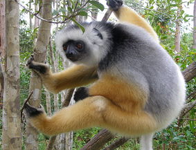 Endangered Diademed sifaka in the wild. @ C.Michael Hogan
Andringitra, another area considered to have been a climatic refugium, is a major centre of endemism, very rich in mammals and herpetofauna, supporting about 50% of the country’s mammals excepting bats, 88 being endemic. The 47 mammals include 14 lemurs, eight carnivores, nine rodents and 16 insectivores, 90% being endemic. It harbors both golden (CR) and greater bamboo lemurs (CR), the aye-aye (EN), indri (EN), diademed sifaka (EN), red-ruffed lemur (EN) and white-collared lemur; also the fossa (EN) and Malagasy mongoose (CR). Of its 62 amphibian and 38 reptile species, which include the golden frog (CR), 29 do not occur in the other parks. Meller’s duck (EN) is one of its 112 recorded bird species (65 endemic). The variety of Andohahela’s habitats is reflected in a varied fauna. Among its 33 mammals, 2 are endemic. There are 15 lemur species including grey bamboo lemur and aye-aye (EN); four others are not found elsewhere. The 12 other mammals include fossa (EN) and Malagasy mongoose (CR). Of 30 reptiles and 34 amphibia, 33 species do not occur in any of the other parks and include the amphibians Anodonthyla rouxi (EN) and Madacassophryne trubae (EN), radiated turtle Geochelone radiata (VU) and the geckos Parageyhira gabriellae, Uroplatus malhelo and U. malama. Of over 110 species of birds, 87 are found in the mountain forest of the east, 57 being endemic, and 83 in the drier west, 31 being endemic. The Madagascar pond heron (EN) occurs.
Cultural Heritage
Humans, mainly from Indonesia, may have arrived on Madagascar about 2.000 to 2,500 years ago. 1,200 year-old settlements are actually recorded. These have had lasting effects on the original biodiversity, and hunting remains widespread, but three species of lemur and the aye-aye survive because eating them is now considered tabu.
Local Human Population
The people are mainly farmers but dependent on the forest for many resources. Despite this, 90% of the country’s forest has been destroyed, mainly by shifting cultivation (tavy) which is still on the increase. These resources include construction timber, firewood, charcoal, palm and bamboo fibre, bushmeat, fruits, honey, plants and animals for the wildlife trade. However, after 2005 the government intended that there should be no inhabitants within the nominated sites. Past exclusion from protected areas without consultation has left surrounding populations suspicious of their benefits, but programs to relieve poverty are slowly beginning to overcome this opposition. There are so far no figures for the populations living in the 2.5 km–wide multiple-use buffer zones, but some of these are dense in places near towns.
Visitors and Visitor Facilities
The government is beginning to encourage ecotourism on a larger scale, hoping to support conservation by bringing economic benefits to surrounding communities, beginning with the grant of half the revenues of the local park. It also aims at improving the marketing, professional services, infrastructure, security and management of the sites, and their popular perception. The program is starting with Mantadia (a popular park near the capital, not in the nomination), Ranomafana and Andohahela, and is to spread later to Marojejy, Masoala and Andringitra. Tourism is already fairly well developed on some sites. Between 1992 and 2004, visitors to the 6 sites numbered 151,535 tourists, with 109,287 going to Ranomafana, near the large city of Fianarantsoa (15,613 in 2004). The other sites, except for Zahamena which is rarely open, averaged 1,680 visitors in 2004. Inadequate access is a problem, but on the sites, walking, often guided tours, camping and visits to habituated lemur groups are encouraged. There are interpretive centres at Andringitra and Andohahela, interpretive shelters at Masoala and Marojejy and a lodge at Ranomafana. Masoala has bungalows, six campsites and four guided trails, with hotels and guestrooms in nearby towns. The northern sites can be accessed from Maroantsetra airport. Andringitra has trails and three well-equipped campsites. Elsewhere, most of the sites have limited tourist facilities and difficult access roads, though these may be developed by concessionaires.
Scientific Research and Facilities
The flora and fauna of Madagascar are amongst the richest, most unusual and most threatened in the world with 81% endemism for all groups though they have been degraded for centuries. Further research may discover more about the evolution of ecological communities which have disappeared elsewhere which makes the island a natural biological, laboratory. For the six sites, exhaustive plant inventories have been compiled, and lists of vertebrates or certain vertebrate families. The avifauna is less well covered. Reptiles and amphibians are also less well researched but are richest in endemic species. There remains much more to be examined. During the past year alone three new species of lemurs have been discovered, and the breeding success of many is threatened by droughts due to climatic change and the loss of habitat for narrowly endemic species. After research, other species have been discovered to be more or less vulnerable than previously thought, and a nationally balanced picture is still subject to variations in the scope of surveys. There is a research station at Ranomafana.
Conservation Value
The sites display notable examples of evolving biological and ecological systems among some of the world’s most diverse, rare and vulnerable floral and faunal communities. Within the six sites alone, 2,598 species in 166 families, 1,039 genera (97 endemic) have been recorded. Nearly all the amphibians are endemic. The six sites form a series of core zones for a future more continuous protection of the eastern rainforests, and act as gene banks and essential water catchments. Madagascar is part of a Conservation International-designated Hotspot; its forests are within a WWF/IUCN Centre of Plant Diversity and it is a BirdLife-designated Endemic Bird Area.
Conservation Management
The nominated sites are the most intact and least threatened of all Madagascar’s protected areas and each is large enough to sustain its populations of wild animals. It was only in 1985, following an international colloquium on Madagascan wildlife, that the country’s protected areas were opened to foreign observers after fifteen years of severely reduced support. More adequate funding was seriously considered and their management structures started to improve. The latest National Park (Befotaka-Midongy), was for the first time ever, established with local agreement, under the Service des Eaux et Forêts. The Malagasy Environmental Charter was passed decreeing protection and the production of regional plans.
Subsequently, in 1991, the first of three 5-year National Environmental Action Plans was launched to combine development with local consent, an admission that the exclusion of local communities was unworkable. Cooperation between government services, NGOs, collectives and commercial interests was initiated. Between 1997 and 1999, six National Parks were created from existing Nature Reserves. A 2.5 km multi-use buffer zone was declared around each site. In 1997, under the second 5-year Environmental Action Plan, large-scale sustainable development with conservation was initiated and most of the 6 sites came under the management of the present Parcs Nationales Malagasy (PNM—ANGAP). This is now advised by an executive body including the WWF, the Wildlife Conservation Society and Conservation International.
In 2001 the Protected Area Plan (Plan de Gestion des Aires Protégées, Plan GRAP) was adopted and in 2002 a management code, the Conservation Management Plan was drawn up on this basis. It was guided by The Nature Conservancy’s ‘5S improved’ model, with principles and measures for the protection and use of all the sites as one system. This provided for eco-tourism, research and environmental education, public awareness and sustainable development in the buffer zones, and for a system of periodic evaluation of management effectiveness based on the WCPA system. Indicators for monitoring the state of conservation, evaluated over one or five year periods, are the levels of natural vegetation cover and habitat loss, the level of threat, and the abundance of key species. But extended funding was blocked for reasons of state and 700 employees were let go, although World Heritage sites were prioritised.
After the Durban World Congress on Parks in 2003, and the announcement of the ‘Durban Vision’ for protected area expansion, by the President, residents and neighboring communities were allowed some use of their local protected area once again, under regulation. The object of the measure was to ensure the viability of the sites in the long term. The sites are also seen as the cores of a future system of extended sites and protected corridors. At present they comprise about 28% of Madagascar’s protected areas, and about 46% of the ecoregion’s protected land. Each park has an excellent and up-to-date management plan describing the present condition of the parks and detailing methods for maintaining, improving and evaluating them. Since 2004, these have been synthesised by PNM-ANGAP into a common Action Plan. Within the buffer zone around each park, PNM-ANGAP can regulate certain activities which impinge on the park, and wider protective zones may be established in the near future. Each park has a management committee which includes representatives from the local people, and many communities have local surveillance committees which help in protecting their area. Monitoring of rare species, logging, resource-collection, edge conditions, and management effectiveness will all be done.
Management Constraints
In the eastern rainforest, 111,000 ha were lost annually between 1950 and 1985, a 50% decline in 35 years (EAZA, 2006), and the remaining forests are very fragmented. The increase in population has increased agricultural encroachment by the use of fire or clearing for grazing or cultivation. The state of conservation of the sites is good, but the park boundaries, especially of coastal and lowland forests, are subject to clearing, woodcutting, logging, over-collecting of resources, hunting, lemur-trapping and disturbance by tourists, pressures also felt by most of the sites. Despite good standardised management plans, the lack of funds and of sufficient trained staff have not halted the ongoing destruction of habitats.
In Marojejy the forest is relatively untouched but subject to local tree-cutting clearing near villages. Masoala was in good condition in 2002 except for clearing and infringements along its borders, its palm groves which are raided for fibre, and the coral reefs which are overfished and damaged by the fishing methods used. Cyclones and fires caused by drought and clearance for grazing are also destructive and their frequency may increase with changing climate.
The southwest quarter of Zahamena is quite infiltrated and the government’s aim to remove settlement from the parks may be difficult there. Ranomafana is split by a main road. The local townsmen benefit from tourism, but the peasants resent being denied use of the forest: the lowland areas are under pressure for rice cultivation and the western side for bamboo-cutting and the taking of crayfish. In Andringitra the local people are hostile. It is subject to most of the pressures plus fire in the open half of the park, which is traditionally grazed. There is also a high number of invasive alien species (Alien species), but the higher forest is intact. The interior of Andohahela is in good condition, and the summits, though cleared by past fires, are even protected by tabus. The park is well received by local decision makers, but several pressures remain: clearing and lemur-hunting in the east, fires, clearing and overgrazing on the dry western margin.
Comparison with Similar Sites
The comparison of the serial nomination with existing World Heritage sites is on the grounds of its biological processes and diverse habitats containing threatened species of global value. The scenic variety from tropical coastal forests and reefs to temperate savanna and subalpine vegetation on a series of escarpment mountainsides is uncommon amongst tropical forest sites. But it is because of its biogeographic isolation that Madagascar is almost unparalleled in the archaic forms and endemism of its many species and the ecological processes that sustain them. Its unique lemurs take the place of primates and of the large animals which no longer occur there. The loss to the world of this rare life would be catastrophic. The nominated sites represent almost all of the major habitats of the most diverse ecoregion in the country, distributed altitudinally over 2,000 metres and over nearly 11 degrees (1,200 km) of latitude. They could form the core of a far more extensive network of contiguous protected rainforests. These forests are very different from the World Heritage site of Tsingy de Bemeraha on the west of the island. Comparable existing World Heritage rainforest sites are the upper and lower Guinean forests of West Africa, the central African Congo forests, the Brazilian Cerrado, the Kampff Mercado Park in Bolivia, the Bornean rainforest between Indonesia and Malaysia (proposed), the Sumatran Rainforest sites and the Central Eastern Rainforest of Australia.
Although they are relatively unremarkable for their numbers of mammals and birds, the nominated sites have high and very varied scenic quality and are exceptional for the variety of their ecological regimes, their large numbers of endemic families, genera and species, especially the lemurs, and for the high numbers of rare, threatened and endemic species of reptiles and amphibians.
Staff
Existing staffing for the six parks totals some 250. Each park has a Director plus three technical sub-directors, for administration and finance, science and education, and maintenance, with an average of ten administrative staff. There are two to five section heads with an average of 18 rangers per park. The parks are managed in cooperation with the Directorates of the four main concerned regions: Antsiranana (Marojejy), Toamasina (Masoala, Zahamena,), Fianarantsoa (Andringitra, Ranomafana) and Tahana (Andohahela).
Budget
Funding comes from the government and from international organisations via the government; also from entry fees. For the 2002-2006 Phase III National Environmental Plan, about US$21,000,000 was needed, and but only US$15,855,000 became available. International aid came from GEF, USAID, DEAP, CI, WCS, the Dutch KfW, the French AFD,the German GOM, WWF & EU.
Local Addresses
- Parcs Nationaux Madagascar (PNM/ANGAP), Immeuble ANGAP Ambatobe BP 1424, Antananarivo 103, Madagascar. angap@wanadoo.mg www.parcs-madagascar.com
- Office National pour l’Environnement, Ave Rainilaiarivony, Antaninarenina BP 822, Antananarivo 101, Service d’Appui à la Gestion de l’Environnement, Ambatoroka – 101 Antananarivo, Madagascar.
Further Reading
The principal sources for the above information were the original nomination for World Heritage status.
- European Association of Zoos and Aquaria (EAZA) (2006). Madagascar.
- Fishpool, L. & Evans, M. (eds) (2001). Important Bird Areas in Africa and Associated islands. Priority Sites for Conservation. Pisces, Newbury / BirdLife International, Cambridge U.K.
- Gautier, L. & Goodman, S.(2003). Introduction to the Flora of Madagascar. In Goodman, S. & Benstead, J. (eds). The Natural History of Madagascar, ed. Chicago University Press, pp. 29-250. Chicago.
- Glaw, V. (2004). A Field Guide to the Amphibians and Reptiles of Madagascar. Germany.
- Goodman, S. & Benstead, J. (2003). The Natural History of Madagascar. Chicago University Press. Chicago and London.
- Goodman, S. et al. (2003). Introduction to the Mammals. In Goodman, S. & Benstead, J. (eds).The Natural History of Madagascar, Chicago University Press, pp. 1159-86. Chicago and London.
- Goodman, S., Bernadin, P. & Rasolonandrasana, N. (2001). Elevational zonation of birds, insectivores, rodents & primates on the slopes of the Andringitra Massif, Madagascar. Journal of Natural History 35(2): 285-305.
- Hilton-Taylor, C.(compiler) (2006).IUCN Red List. of Threatened Species. IUCN, Gland/ Cambridge UK.
- Ministère de l'Environnement, Eaux et Forêts (2001). PlanGrap. Antananarivo, Madagascar.
- ------------------------------------------------------------- (2006). Nomination des Forêts Humides de l’Atsinana pour Inscription sur la Liste du Patrimoine Mondiale de UNESCO. Government of Madagascar.
- ------------------------------------------------------------- (2007). Responses au Recommendations de IUCN Concernant la Proposition d’Inscription des Forêts Humides de l’Atsinana pour Inscription sur la Liste du Patrimoine Mondiale. Antananarivo, Madagascar.
- Raxworthy, C. (2003). Introduction to the Reptiles. In Goodman,S. & Benstead, J. (eds).The Natural History of Madagascar, Chicago University Press, Chicago and London.
