Qionglai-Minshan conifer forests
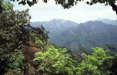
The mountains that flank the eastern rim of the Tibetan Plateau are some of the highest and steepest on Earth with peaks that exceed 7,500 meters (m). Middle elevations support dense coniferous forests with an understory of arrow bamboo. This cool, foggy realm provides habitat for the last of the giant pandas. Luckily, there are many reserves which protect this critically endangered animal, as well as others in this high diversity ecoregion. The mountains of this region are too steep to support agriculture and much of the vegetation of the area remains pristine. However, poaching of animals, namely for fur, has driven many animals to the brink of extinction.
Location and General Description
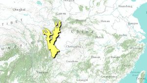
The Qionglai–Minshan mountain system separates Amdo, on the eastern edge of the Tibetan Plateau, from the low-lying Sichuan Basin. In height and steepness, the Qionglai is equaled only by the Karakoram and the Eastern Himalaya, the other mountains that flank the Tibetan Plateau. Here, the highest peaks exceed 7,000 m with many ridges higher than 4,000 m. Gongga Shan, the highest summit at 7,556 m, is so steep that the glaciers on its east face tumble down well below tree line before they finally melt. Adjacent river valleys may cut to elevations of 1,000 to 2,000 m. Although located at subtropical latitudes, significant winter snow accumulates above 3,000 m, and coniferous forests are dominant at the middle and upper elevations. Like mountains throughout the world, forest species composition here is stratified according to elevation. Although precipitation also affects species composition, the elevational trends predominate. A typical sequence in this ecoregion is Pinus spp. in the drier, lower elevation valleys (mainly P. tabuliformis in the north, P. armandii in the south), with Picea spp. (P. likiangensis in the south, P. brachytyla, P. purpurea or P. wilsonii in the north), Abies delavayi, and Larix potaninii abundant above 3,000 m. Late successional forests at favorable elevations consist of mixed stands of Abies spp. and Picea spp., although the species vary from one place to another. Juniperus spp. (J. chinensis or J. saltuaria) may grow at the highest elevations, especially in rocky places with well-drained, basic (limestone) soils. Tsuga spp. is also an important component of the coniferous forest ecosystem in some areas.
Forest zonation patterns here are similar to the Hengduan Mountains and Yunnan Plateau a few hundred kilometers to the south, except that the altitudinal zones occur at a lower elevation in the Qionglai due to the latitude difference. There are some important climatic differences as well, including greater winter precipitation and a less-pronounced summer monsoon.
Although they are classified as coniferous forests, it is important to understand that these forests also include deciduous broad-leaved trees that may form a lower canopy through which the conifers emerge. In some places, the broad-leaved trees are more numerous and may occupy a greater basal area than the conifers. Common deciduous broad-leaved taxa include Acer spp., Betula spp., Sorbus spp., Viburnam spp., Daphne spp., and Mussaenda spp.. Thickets of medium to small-statured bamboo also grow here and provide a critical food resource for both giant pandas (Ailuropoda melanoleuca) and red pandas (Ailurus fulgens).
Open areas near tree line are often covered in a closed shrub layer of Rhododendron spp. (this area has many species), together with deciduous shrubs such as Rosa spp.and Berberis spp. Mountain ridges above 4,000 m support alpine vegetation that is ecologically and floristically similar to the adjacent Southeast Tibet shrublands and meadow ecoregion.
Dry valleys may occur at elevations of 1,500 to 2,500 m in the gorge of the Min River and its tributaries. Here, vegetation consists of a sparse cover of dwarf shrubs scattered on a landscape of bare earth. Shrubs tend to branch densely and have very small leaves that are thorny or contain aromatic oils, adaptations typical of arid conditions. Common shrubs here include Acacia farnesiana and Pistacia weinmannifolia. The cactus, Opuntia monocantha, introduced from the New World, has become naturalized in these valleys and is now very abundant in some areas.
Biodiversity Features
Some of the landscapes in this ecoregion have received international attention and special conservation status because they provide habitat for giant pandas and other charismatic mammals like red pandas and takins. In fact, the panda’s habitat supports very high levels of biodiversity overall. Thus, it is fortunate that the biota here includes such a flagship mammal species as the giant panda, a symbol around which scientists have been able to mobilize national and international support for habitat conservation. More recently, some of the panda reserves like Wolong and the Huanglang-Wanglang-Jiuzhaigou complex have been recognized as important tourist sites as well, and efforts are well underway to encourage more paying visitors, both Chinese and international.
Yunnan golden monkeys (Rhinopithecus bieti) are also present in this ecoregion, but their habitat is farther south in the forests of Northwest Yunnan near the first great bend in the Upper Yangtze River. Several large cat species occur throughout this ecoregion. The most abundant is the common leopard (Panthera pardus).
Current Status
The mountains that comprise this ecoregion are too steep, cool and humid for extensive agriculture. As a result, human population density is low. The landscape is wilder than in most other parts of Sichuan, and the vegetation in many areas is relatively pristine.
Panda conservation through effective habitat protection is recognized by the Chinese government as an important goal, yet it is also understood that merely excluding human activity from the panda’s habitat is not sufficient to conserve the panda, nor culturally appropriate. During 1999, a new Panda Conservation Strategic Plan was formulated using integrated conservation and development as its cornerstone. Pilot projects are currently underway in Pingwu County, Northern Sichuan, an area that is thought to support about 300 wild pandas and where logging was recently banned by the central government in an effort to control flooding on the Yangtze River. Components of this project include participatory forest-use planning, wildlife conservation, exploring alternative livelihoods through ecotourism, and sustainable marketing of non-timber forest products.
Types and Severity of Threats
Despite the remoteness of the area, human impacts do occur. Among the most severe are logging and hunting. These mountains were subject to very heavy logging until 1998 when the government of China declared a moratorium on this activity due to concerns that deforestation was contributing to siltation and flooding on the Lower Changjiang (Yangtze) River. Hunting and collecting of non-timber forest products is difficult to quantify, but markets throughout Southwest China (and increasingly throughout China as a whole) sell products collected from the mountains in this part of China. These include pelts (snow leopard, wolf, serow, leopard, and black bear) and many medicinal plants, including a number of taxa like the cushion plant Arenaria spp. and the thickly tufted Saussurea spp.that come from the high alpine areas.
In the village of Songpan, along the upper reaches of the Min River (Aba Prefecture, Sichuan Province), more than 15 snow leopard pelts were displayed for sale during visits in September 1999 and June 2000. While some of the furs on display were artificially colored, many were obviously genuine. Wolf pelts, penises of tigers and leopards, tiger claws and bear paws and gall bladders are also sold openly in markets throughout the region. The sale of most of these products, especially those derived from the tigers and snow leopards, is prohibited both in China and by international treaty. In the Jade Dragon Nature Protection Area, local performers wear hats fashioned from intact red panda pelts. These hats are entirely for tourism and are not part of the local cultural traditions.
Tourism is on the increase throughout Southwest China. The vast majority of the tourists are domestic travelers. A significant number come from other parts of Asia. Western tourists are in the minority. As this area opens to the world, products once collected from the wild for local consumption are being offered to a much larger market.
Justification of Ecoregion Delineation
This ecoregion consists of the isolated high plateau and mountains surrounding Sichuan Basin, including Lianshan and the basins of Min and Dadu Rivers. The CVMCC Vegetation Map of China classes included are: cold-temperate spruce and fir, alpine evergreen broadleaf, and mixed evergreen and deciduous broadleaf. Chang Jian is the southern boundary. This is comparable to the Liangshan and Quonglai-Minshan biogeographic subunits in the Sichuan-Yunnan Highlands according to Mackinnon et al.
Additional information on this ecoregion
- For a shorter summary of this entry, see the WWF WildWorld profile of this ecoregion.
- To see the species that live in this ecoregion, including images and threat levels, see the WWF Wildfinder description of this ecoregion.
- World Wildlife Fund Homepage
Further Reading
- Chinese Vegetation Map Compilation Committee. 1979. Vegetation map of China. Map (1:10,000,000). Science Press, Beijing, China. ISBN: 7030089561
- Harkness, J. 1999. WWF China Programme Office Annual Report. World Wildlife Fund.
- Lancaster, R. 1989. Travels in China, a Plantsman’s Paradise. Antique Collectors’ Club Ltd. Woodbridge, Suffolk, England. ISBN: 1851495150
- Li Wenhua. 1993. Forests of the Himalayan-Hengduan Mountains of China and Strategies for their Sustainable Development. International Centre for Integrated Mountain Development (ICIMOD). Kathmandu, Nepal.
- Mackinnon, J., M. Sha, C. Cheung, G. Carey, Z. Xiang, and D. Melville. 1996. A biodiversity review of China. World Wide Fund for Nature, Hong Kong.
- Schaller, George. The Last Panda. ISBN: 0226736296
| Disclaimer: This article is taken wholly from, or contains information that was originally published by, the World Wildlife Fund. Topic editors and authors for the Encyclopedia of Earth may have edited its content or added new information. The use of information from the World Wildlife Fund should not be construed as support for or endorsement by that organization for any new information added by EoE personnel, or for any editing of the original content. |

