Polynya
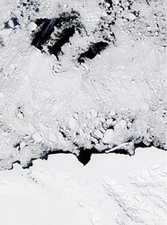
A polynya is an area of persistent open water where one would expect to find sea ice. For the most part, polynas tend to be roughly oval or circular in shape, but they can be irregularly shaped, too. The water remains open because of processes that prevent sea ice from forming or that quickly move sea ice out of the region. There are two types of polynyas (described below), differentiated by the mechanism of ice removal. One process often dominates in a given polynya, but both can occur.
Contents
Sensible-Heat (Open-Ocean) Polynyas

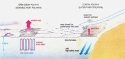
Sensible-heat transfer occurs between two bodies at different temperatures that are in contact with each other. The body with the higher temperature transports sensible heat to the body with the lower temperature. A sensible-heat polynya forms when water that is above freezing upwells, or moves from the lower depths of the ocean to the surface. Heat transfers from the warmer water to the ice, melting it, and preventing new ice from forming. The topography of the ocean bottom or overturning of water causes the warm water to rise to the surface. In this type of polynya, sensible heat from the ocean provides the source of heat needed to melt the ice. Sensible-heat polynyas usually form in mid-ocean areas, far from coasts or other barriers.
Latent-Heat (Coastal) Polynyas
Latent-heat transfer occurs when matter changes state; latent heat is absorbed when ice melts, and it is released into the surroundings when liquid water freezes. The process is called "latent" because it is not associated with a change in temperature, but rather with a change of state.
A latent-heat polynya is characterized by ocean water at the freezing point. It forms as a result of winds blowing in a persistent direction that push the ice away from a barrier, such as the coast, fast ice (ice that is anchored to the shore or ocean bottom), a grounded iceberg, or an ice shelf. As new ice grows within polynyas, wind blows it to the leeward side, while the windward side remains ice-free. Latent heat is released as water freezes and also as water evaporates into the air above the open water. Some sensible-heat exchange also occurs within latent-heat polynyas because the water in the polynya is generally warmer than the air above it even though the water is at freezing temperature.

When sea ice forms in polynyas or elsewhere, salt is expelled into the water, raising the salinity of the near-surface water. The salt increases the density of the surface water, making the surface water heavier than the water below, causing it to sink. In some cases, the high-density surface water mixes with other masses and sinks all the way to the ocean bottom. Latent-heat polynyas, particularly those in the coastal regions of Antarctica, are a major source of the world's bottom waters, which influence the process of thermohaline circulation.
Polynyas are important for various reasons. Like leads, they are a source of heat and moisture to the atmosphere, so they modify the weather in surrounding areas. As discussed above, they are sources of ocean bottom water. Polynyas are also important resources for wildlife. They provide access between the ocean and atmosphere for a variety of animals, including seals and penguins. Because polynyas persist for longer time periods than leads, and because overturning ocean water brings nutrients to the surface, phytoplankton thrive in polynyas. Phytoplankton are microscopic plant-like organisms that form the basis of the marine food chain. During the summer, Antarctic polynyas are one of the most biologically productive regions in the world's oceans.
Recent Trends in Polynya Growth
From the year 2012 to 2021 there is a trend of expanding sea ice as measured by satellite data. The main benchmark index used to establish this trend is the minimum sea ice cover at the end of the summer season. (National Snow and Ice Data Center, 2021) Hence polynya extent has shown a decadal contraction at the present, 2021. This can allow increased shipping access to deliver supplies in cold regions.
References
- Meredith, Michael P. , Nicholls, Keith W. , Renfrew, Ian A., Boehme, Lars, Biuw, Martin, Fedak, Mike (2011) Seasonal evolution of the upper-ocean adjacent to the South Orkney Islands, Southern Ocean: results from a “lazy biological mooring”. British Antarctic Survey. Natural Environment Research Council
- U.S. National Snow and Ice Data Center (2021) Arctic Sea Ice News and Analysis
Citation
| Disclaimer: This article is taken wholly from, or contains information that was originally published by the U.S. National Snow and Ice Data Center. Topic editors and authors for the Encyclopedia of Earth have edited its content and added new information. The use of information from the National Snow and Ice Data Center should not be construed as support for or endorsement by that organization for any new information added by EoE personnel, or for any editing of the original content. |