Ecoregions of Panama
Caribbean coast of Panama. Source: C.Michael Hogan
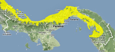 Panama with Isthmian Pacific moist forests in yellow. WWF
The Ecoregions of Panama are shaped by the jagged elongated geometry of the country, its varied terrain within Mesoamerica and its tropical climate. This key land bridge connecting North America and South America provides a mixing zone for the species of these two continents. This mixing began at least 31 million years before present, when small mammals suceeded in swimming and island hopping generally in a southward migration. Approximately three million years ago, when the land bridge became effective, a much more robust two-way faunal migration transpired, with the preponderance of successful migrants moving from north to south. This isthmus migration is often termed the Great American Biotic Interchange. The slenderness of the width of Panama provide every part of the country with reasonable proximity to the Pacific Ocean as well as the Caribbean Sea component of the Atlantic Ocean. The Panama Canal connecting these two major marine environments provides effective biological contact between these two marine basins.
Contents
List of Panama ecoregions
Ecoregions are areas that possess each of the following attributes: (a) share a strong majority of their species and ecological dynamics; (b) share similar environmental conditions; and (c) interact ecologically in fashions that are critical for long term persistence. Scientists at the World Wildlife Fund have established a classification system that partitions the world terrestrial component into 867 non-overlapping regions; the classification system also recognizes 426 freshwater ecoregions and 229 marine ecoregions.The following terrestrial ecoregions have thus been defined in Panama:
- Mesoamerican Gulf-Caribbean mangroves NT1403, Northwestern coastal Panama continuing northwesterly into coastal Costa Rica and disjunctively to southern Mexico
- Isthmian-Atlantic moist forests NT0129, Lowland forest of central Panama bordering the Caribbean Sea
- South American Pacific mangroves NT1405, Southeastern coastal Panama rimming the Gulf of Panama on the Pacific versant (World Wildlife Fund, 2001a)
- Eastern Panamanian montane forests NT0122, Extreme southeastern Panama montane forests (World Wildlife Fund, 2001b)
- Chocó-Darién moist forests NT0115, Extreme eastern Panamanian provinces of Darién and Kuna-Yala, continuing along almost the entire Colombian Pacific coast (World Wildlife Fund. 2001c)
- Panamanian dry forests NT0224, Premontane dry forest above the Parita Bay in Pacific Panama (includes a strip of transition zone to tropical moist forests to the north and west)
- Isthmian-Pacific moist forests NT0130, Lowland moist forests of southwestern Panama continuing west into Costa Rica (World Wildlife Fund. 2001e)
- Bocas del Toro-San Bastimentos Island-San Blas mangroves NT1407 Coastal Mangrove blocks of western coastal Panama extending to Costa Rica (World Wildlife Fund. 2001f)
- Talamancan montane forests NT0167, Montane moist forests of western Panama extending into eastern Costa Rica (World Wildlife Fund. 2001g)
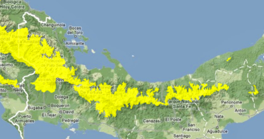 Panamanian Talamancan montane forests in yellow. WWF
The codes used are those developed by the World Wildlife Fund.
Biodiversity
Extensive biodiversity within Panama includes a species richness promoted by the unique location as an isthmus connecting the two American continents, and due to the varied climate and topography with exposure to two different ocean regimes; the latter effects generating sharp ecological gradients. In the case of Panama the sharp gradient is achieved by traversing dramatic changes in altitude and terrestrial biomes in the very short distance from the Caribbean to the Pacific side of Panama. This steerp ecological gradient is presumed to explain the high beta diversity of rainforest trees in Panama, relative to Amazonia, for example. (Dick et al. 1985) This unique ecological terrestrial join of North and South America was formed approximately three million years ago, when volcanic action and tectonic uplift created a landform upon the prior seabed.The Great American Biotic Interchange ensued with the majority of sucessful migrants being southward moving species.
The chief biomes within Panama are mangrove blocks, montane and lowland moist forests. A high incidence of endemism is also correspondingly associated with all parts of Panama. There ar twelve endemic bird species within Panama, but a total of regional endemic avafauna. Five of the twelve national endemic bird species are present in the Darien highlands and lowlands; one of the endemic birds, the Escudo Hummingbird, is found only on Panama's Escudo de Veraguas Island. The Cordillera de Talamanca extending from western Panama into Costa Rica is also an important area of bird regional endemism (Caldecott. 1996) and species diversity. Moreover, there are a total of 105 regional endemic birds present in Panama, with four other national endemic birds found on Panama's south-central Pacific slope and two found only within the Panama portion of the Panama/Costa Rica highlands.
In terms of flora, there is considerable Panamanian biodiversity, although trees and lianas evince only moderate endemism; (D'Arcy et al. 1985) however, an exception to the high canopy endemism is Barro Colorado Island within Gatun Lake of Panama, where eleven percent of the epiphytes, twelve percent of lianas and fifteen percent of tree species endemic to Panama. In other mainland Panama Canal watershed rainforests merely nine percent of the trees were found to be Panamanian endemics.
Natural history
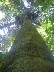
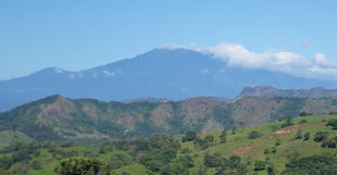 Talamancan montane forests. Foreground: montane forest disturbed by clearance for grazing; midground: rocky screes inhospitable to trees; background: the densely forested slopes of Volcan Baru, Panama. Source: C. Michael Hogan
 It is clear that the formation of the Panamanian land bridge approximately three million years ago allowed the blending of flora and fauna taxa from North and South America. North American indigenous species contributed disproportionately to montane taxa (greater than 2000 m), while northward diffusion from South American flora contributed most of the lowland forest (less than 1000 m) species.(Harmon. 2005) Dick et al. posit that most rainforest trees in Panama participated in the Great American Biotic Interchange, since 61 percent of the trees in one central Panama study were Cross-Andean Distribution species, implying that they were of sufficient age to have undergone the long dispersal transit north.
Fossil evidence in Panama indicates that rainforests were present in central Panama as early as the Miocene era. Moreover, Miocene grasslands here supported large grazers such as horse and hippopotami.
Exploration history
The early exploration of the ecoregions of Panama has scant recording prior to the year 1848. Coastal probing and mapping of the Caribbean shores of present day Panama occurred as early as 1501 and 1503 by Rodrigo de Bastidas and Christopher Columbus. Further recording of some basic coastal biotic conditions were made by Vasco Núñez de Balboa and Gaspar de Espinosa in the early sixteenth century, with the latter conducting interior reconnaisance into the Pacific lowland forests at least as far inland as the town of Santiago. It has been suggested that Chinese explorers may have visited the Panamanian shores as early as the 1420s, although recordings of the long distance Chinese navigators of that era are deemed lost in the noted mass document destruction of the Chinese xenophobic period starting in the mid fifteenth century.
The earliest scientific exploration of detailed recording of Panama's ecoregions began (Seeman. 1852-1857) in 1848 with the arrival of Berthold Seeman, botanist of the HMS Herald. Seeman collected and described a vast array of Panama's trees, shrubs and herbaceous species. At that time dense rainforests occupied a full two thirds of Panama's land area. On the Pacific coast lowlands Seeman described the forests, savannas and grasslands as virtually unharmed by native agriculturalists; the human population within what is present day Panama is estimated to have been 130,000 in the year 1850. (Heckadon-Moreno. 2004) According to the Heckman-Moreno analysis of Seeman's records, the central Pacific slopes were much more verdant in the Seeman exploration era, likely due to greater water retention of surface organic detritus and greater depth of topsoil prior to the onset of intensive agriculture that began in the mid nineteenth century.
Furthermore, Seeman reported the abundance of deer, Cervus cerrado, throughout the Pacific lowlands, and he noted that "alligators were abundant at all the river mouths". He also recorded high amphibian densities in moist areas, and recorded jaguar and puma sightings as frequent. Seeman was the first to characterize the biota of present day Panama as extremely rich and diverse. Seeman's observations imply the climate of mid 19th century Panama may have been hotter (with temperatures up to 124 degrees F), with more intense, longer duration rainstorms (illustrated by severe periodic flooding in areas not subject to such a high level of present floodwaters).
Josef von Warcewicz was another early biological explorer, whose specialties were orchids and hummingbirds. He ventured further into western Panama than Seeman, probing not only the Volcan Baru area, but reaching the Caribbean shores at Bocas del Toro. He remarked on the extensive savannas and gallery forests south of Boquete; he claimed that the forests on the eastern slopes of Volcan Baru to be a "paridise for orchid collectors". He asserted that he made the first recorded ascent to the volcano rim. Slightly later in the 19th century Wilmot Brown Jr. further recorded transects on the eastern and southern slopes of Volcan Baru. He noted very dense birdlife at elevations of 900 meters, which is the approximate start of the montane moist forests. Above the cloud forest he observed an unusual high montane forest belt commencing at approximately 2550 m, where stunted tree forms were covered by "cold saturated mosses". Brown recorded the treeline of the volcanic slopes at around 2800 m elevation.
Conservation
 Royal Palm, Attalea butyracea, El Parque Natural Metropolitano dry forest, Panama
 Panama's ecoregions have lost considerable biodiversity since the advent of man in Mesoamerica, which entrance occurred approximately 13,000 to 11,000 years before present; however, while megafauna were substantially reduced by indigenous peoples, the greater loss of habitat ensued with the advent of Europeans. The earliest broad-scale destruction of ecosystems was carried out on the central and western lowland Pacific slopes, where Spaniards cleared massive savannas and forests to introduce livestock grazing. Today these Isthmian-Pacific moist forests and Panamanian dry forests retain little of their pre-European contact ecological integrity, not only from habitat loss, but also from habitat fragmentation and introduction of alien species. Furthermore, surface water retention has been greatly diminished since conditions reported in the mid nineteenth century. An opportunity for partial habitat restitution lies in regrowth of forests, especially in locations that may connect intact forests in the form of habitat corridors; this strategy could be economically viable, since historic grazing has resulted in inefficient production, with large tracts of land being disturbed without always being utilized subsequently. Some region by region detail is presented in the following.
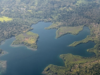
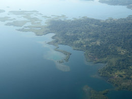 Aerial photograph of rugged shoreline and Bocas del Toro Archipelago, Panama. Source: C.Michael Hogan
 The chief threat to the Isthmian-Pacific moist forests is ongoing conversion to agricultural uses, including grazing. Specific to western Panama, the threat of damming the Rio Chiriqui would destroy significant areas of riparian habitat and also contribute further to habitat fragmentation of this ecoregion. The lower slopes of Volcan Baru containing moist forests are susceptible to a recently accelerating development pace, with elements of residential sprawl and poorly planned conversion to grazing. Viable conservation strategies for this vulnerable region are: (a) discouraging grazing land conversions, especially in and near protected areas such as the Volcan Baru National Park; (b) discouragement of residential development that is uncompact or poses habitat fragmentation issues; (c) avoidance of impoundment of the Rio Chiriqui or other high value riverine habitats; and (d) encouraging ecotourism within low intensity impact and sustainable use models. An example of successful achievement of the low impact ecotourism model for this ecoregion is the Finca Lerida ecotourism lodge/ coffee plantation; here the emphasis on coffee growing is placed on manual methods that minmize soil disturbance, avoidance of agri-chemicals and preservation of surrounding intact primary forest. Limited access visitation allows guests to experience high quality intact forest ecology, birdwatching and observation of farming methods that are polyculture based, since native plants are used as groundcover, shade and windbreaks.
In the Bocas del Toro-San Bastimentos Island-San Blas mangroves, the principal threat to terrestrial biodiversity is the steady conversion of islands for residential and visitor serving uses. The archipelagos here are centers of burgeoning tourism, due to the relatively mild climate, natural beauty and water oriented tourism.There is considerable ecological value in this ecoregion, not only from presence of endemics, but also due to the uniqueness of the island and coastal ecosystems, that have considerable intact elements; furthermore, the ecoregion supports a number of endangered sea turtles, amphibians and other fauna of limited distribution. There is a current need for considerable protection of both upland and coastal habitats, notably on Isla Bastimentos and Isla Colon, where habitat fragmentation is presently occurring. Furthermore, the coastal waters are threatened, by not only destruction of shoreline mangroves, but also from near shore sediment loads that are swollen from increased surface runoff (Surface runoff) from upland grading and earth disturbance. The enhanced turbidity threatens marine fishes, and ensuing benthic sediment harms vulnerable coral reefs. Without timely steps to limit development, some of these fragile islands may emulate the eco-disasters of Easter Island or Hawaii. Specifically, intelligent master planning of ecotourism and residential uses are warranted throughout this ecoregion.
Panamanian dry forests are important because they are high in endemism and of small geographic extent. Most of this ecoregion is defined by a low lying coastal area above Parita Bay; however, there relict dry forests in the vicinity of the Chagres River mouth along the Gulf of Panama, notably the Parque Natural Napolitano in Panama City. In all these dry forest areas there is continuing pressure, since they are easily accessible and offer relatively enticing development potential, being some of the more gently sloping terrain in Panama. The remnant dry forests near the mouth of the Chagres face intense urban development pressures; as these forest fragments grade into the lowland moist forest around Gatun Lake and Gamboa, there is further pressure in this transitional zone from tourism demand and expansion of the Panama Canal. A clearer pattern of protection is warranted to fold the existing conservation areas such as Soberania National Park into a north-south biological corridor along the Canal Zone. Land use and grading controls would be beneficial to minimize the habitat destruction ancillary to the canal expansion; such conservation planning would not only maximize retention of forests, but also promote topsoil conservation.
Chocó-Darién moist forests are an area of high endemism and species richness. While the relative remoteness of this region is an aid in protection, the steady pressure of agricultural land conversion and resulting habitat fragmentation pose threats to these forests. The Panama Audubon Society and other conservation groups have efforts underway to preserve key biological corridors; it is important that the Panamanian government support these endeavors, both in regulatory structure as well as financially for land acquisition.
References
- World Wildlife Fund. 2001f. Bocas del Toro-San Bastimentos Island-San Blas mangroves (NT1407)
- World Wildlife Fund. 2001g. Talamancan montane forests (NT0167)
- Julian Oliver Caldecott. 1996. Designing conservation projects, page 121, Cambridge University Press, Cambridge, England
- William G. D'Arcy, D. Mireya and A. Correa. 1985. The Botany and Natural History of Panama, Universidad de Panamá. , 455 pages
- Russell S. Harmon. 2005. The Rio Chagres, Panama: a multidisciplinary profile of a tropical watershed, page 261
- Christopher W. Dick, Richard Condit and Eldridge Bermingham. 1985. Biogeographic history and the high biodiversity of rainforest trees in Panama, Smithsonian Institute, in The Botany and Natural History of Panama (eds. W.G.D'Arcy, D.Mireya & A.Correa)
- Berthold Seeman. 1852-1857. The botany of the voyage of HMS Herald. Lovell Heave. London.
- Stanley Heckadon-Moreno. 2004. Naturalists of the Isthmus of Panama. Smithsonian Tropical Research Institute