Northern Canadian Shield taiga
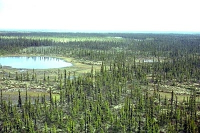
South Knife Lake, Manitoba, Canada Photograph by Lynda Dredge/Used with permission of the Geological Survey of Canada, Natural Resources Canada
|
|
The Northern Canadian Shield taiga ecoregion covers a large area of the Northwest Territories, extreme northeastern Alberta, northern Saskatchewan, and northwestern Manitoba.
Short, cool summers and very cold winters typify this ecoregion. In fact, Yellowknife, on the north shore of Great Slave Lake, has the lowest mean annual temperature of any major city in all of Canada (-5°C). Generally, however, mean annual temperature ranges from -8°C to -5°C, mean summer temperature ranges from 8°C to 11°C, and mean winter temperature is between -24.5°C and -21.5°C. Mean annual precipitation is in the range of 200-400 millimeters (mm). This ecoregion is classified as having a low to high subarctic ecoclimate.

Massive, crystalline Archean rocks form broad, sloping uplands and lowlands, with numerous small lakes and eskers that drain into Great Slave Lake. Bedrock outcrops are common, and maximum elevation reaches about 490 meters (m) above sea level (asl). Permafrost is discontinuous to continuous, with low to medium ice content with sparse ice wedges throughout.
Contents
Biological Distinctiveness
The limit of tree growth is reached along the northern boundaries of this ecoregion. The ecoregion as a whole constitutes the tundra and boreal transition zone. Vegetation consists of open, very stunted stands of black spruce (Picea mariana) and tamarack (Larix laricina), with secondary quantities of white spruce (Picea glauca) and ground cover of dwarf birch (Betula sp.), ericaceous shrubs (Ericaceae), cottongrass (Eriophorum spp.), lichen and moss. Drier sites can support open stands of white spruce, ericaceous shrubs and a ground cover of mosses and lichens. Poorly drained sites support tussock vegetation of sedge (Carex spp.), cottongrass, and sphagnum moss (Sphagnum spp.). Vegetation in the Tazin Lake Upland in the southwestern region is characterized by medium to tall closed stands of quaking aspen (Populus tremuloides) and balsam poplar (Populus balsamifera), with white spruce, balsam fir (Abies balsamea) and black spruce occurring in late successional stages. Fire is an important renewal agent for upland communities in this ecoregion.
Species inhabiting this ecoregion include moose (Alces alces), grizzly bear (Ursos arctos), black bear (U. americanus), wolf (Canis lupus), barren-ground caribou (Rangifer tarandus spp. arcticus), wolverine (Gulo gulo), weasel (Mustela spp.), mink (Mustela vison), muskrat (Ondatra zibethica), otter (Lontra canadensis), beaver (Castor canadensis), snowshoe hare (Lepus americanus), brown lemming (Lemmus sibiricus), red-backed vole (Clethrioomys gapperi), willow ptarmigan (Lagopus lagopus), rock ptarmigan (L. mutus), sandhill crane (Grus canadensis), osprey (Pandion haliaetus), raven (Corvus corax), spruce grouse (Dendragapus canadensis), and waterfowl.
This ecoregion represents nearly one quarter of the linear extent of the tree line in North America. Wolf denning is common along the treeline. The combination of forests and tundra in this ecoregion results in significant overlap of woodland and barren-gound caribou (Rangifer tarandus ssp. arcticus) herds. Major caribou herds include the Bathurst herd and the Beverley-Quaminirauq herds. This is perhaps the most frequented area in northwestern Canada for caribou in terms of their winter range.
Conservation Status
Habitat Loss and Degradation
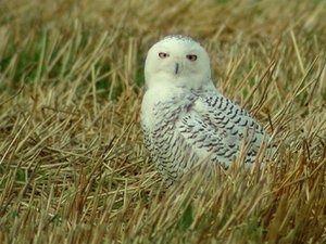 Snowy owl (Nyctea scandiaca), Canada. (Photograph by Ann Cook & CalPhotos)
 It is estimated that 90-95 percent of the natural habitat in this ecoregion remains intact. The most widespread form of habitat disturbance relates to mining and mineral exploration. This activity is growing rapidly in the western half of this ecoregion. Uranium, diamonds, nickel, and copper are some of the important minerals that constitute the mining industry in this area. Hydro-electric development is of concern in northern Manitoba and parts of the Northwest Territories. Urban development along the north shore of Great Slave Lake is having local impacts on natural habitats.
Remaining Blocks of Intact Habitat
Most of the ecoregion remains intact.
Degree of Fragmentation
Greatest fragmentation is occurring in the western portion of the ecoregion where permanent and winter roads for mining and mineral exploration are increasing land-based access to the area. Some additional habitat fragmentation is possible with respect to flooding associated with extensive, future hydro-electric projects, particularly in eastern portions of the ecoregion.
Degree of Protection
Protected areas are primarily clustered in the southeastern portion of the ecoregion. Part of Thelon National Wildlife Sanctuary occurs in the north-central portion of this ecoregion in the Northwest Territories.
- Sand Lakes Provincial Park - northwestern Manitoba - 8,475 km2
- Caribou River Provincial Park - northwestern Manitoba - 7,515 km2
- Numaykoos Lake Provincial Park - northwestern Manitoba - 3,695 km2
- Baralzon Lake Ecological Reserve - northwestern Manitoba - 390 km2
Types and Severity of Threats
Fly-in hunt camps need to be monitored to ensure that there are not unsustainable levels of caribou harvest occurring. The grizzly bear population in this ecoregion is at relatively low densities due to the carrying capacity of the landscape. Hence, even low numbers of animals destroyed as a result of them becoming 'problem bears' near mining camps is of concern. There may be loss of terrestrial habitat resulting from flooding associated with proposed hydro-electric projects.
Suite of Priority Activities to Enhance Biodiversity Conservation
Establishing more protected areas. Some candidates that have been identified include:
- East Arm of Great Slave Lake, Northwest Territories as a national park
- Hasbala Lake, Saskatchewan
- Arctic Butte, Saskatchewan
- Grease River, Saskatchewan
- Tazin Lake, Saskatchewan
- Cracking Stone Peninsula, Saskatchewan
- Tribal Park proposals put forward by First Nations in the Northwest Territories
Conservation Partners
- Canadian Nature Federation
- Ecology North
- Endangered Spaces Campaign, Manitoba
- Endangered Spaces Campaign, Saskatchewan
- Manitoba Future Forest Alliance
- Manitoba Naturalists Society
- The Nature Conservancy, Manitoba
- Nature Saskatchewan
- Resource Conservation Manitoba
- World Wildlife Fund Canada
| Disclaimer: This article contains information that was originally published by the World Wildlife Fund. Topic editors and authors for the Encyclopedia of Earth have edited its content and added new information. The use of information from the World Wildlife Fund should not be construed as support for or endorsement by that organization for any new information added by EoE personnel, or for any editing of the original content. |