North Western Ghats montane rain forests
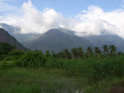
Western Ghats near Rajapalayam, Tamil Nadu (Source: Pragadeeshraja via http://en.wikipedia.org/wiki/Western_Ghats)
Introduction The North Western Ghats Montane Rain Forests are one of two montane (North Western Ghats montane rain forests) rain forest ecoregions (the other is the South Western Ghats Montane Rain Forests) along the Western Ghats Mountain Range, renowned for its large number of species, particularly endemics. For instance, about a third of the plants, almost half the reptiles, and more than three-fourths of the amphibians known in India are found in this narrow strip of rain forest near the west coast of India. Even among the non-endemic fauna, species such as tigers, elephants, langurs, hornbills, and king cobras that conjure up romantic visions of the subcontinent's jungles inhabit these forests. The Wyanad evergreen forests of Kerala-Karnataka represent a transition zone from the moist Cullenia-dominated forests in the south Western Ghats to the northern drier dipterocarp forests.
Location and General Description
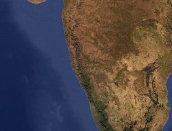
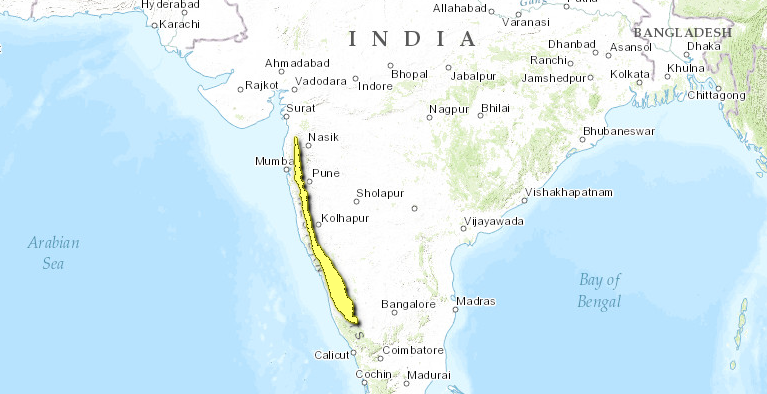
The ecoregion extends through the states of Tamil Nadu, Kerala, and Karnataka, on to Maharashtra State in western India. The ecoregion includes the middle- and upper-elevation biomes of the North Western Ghats Mountain Range.
 WWF
WWF
As part of the Deccan Plate, the ecoregion has Gondwanaland origins, although the Western Ghats Mountains were created by post-Cretaceous uplift after the northward drifting Deccan Plate collided with the northern Eurasian continent. The resulting mountains intercepted the June to September southwest monsoon, resulting in the deposition of more than 2,500 millimeters (mm) of rainfall along their windward western slopes. The range's rain shadow creates drier conditions on the eastern slopes. Three large rivers, the Godavari, Krishna, and Cauvery, carry the rainfall from the monsoon rains eastward, all the way across the vast Deccan Plateau. The mountain range ascends abruptly on the western side from near sea level to 2,700 meters (m) and descends just as abruptly to 500 m onto the Deccan Plateau. The deeply dissected terrain produces localized variations in rainfall and habitat types and creates hotspots of endemism by limiting species distributions.
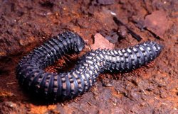 Armoured millipede, India. (Source: Photograph by © Persica/Abi Tamim)
 The multistoried rain forests with tall, buttressed trees exceeding 45 m are replete with climbers: lianas and epiphytes. Orchids in particular are plentiful. The forests are dominated by species of Dipterocarpaceae, Clusiaceae, Anacardiaceae, Sapotaceae, and Meliaceae. Bamboos, palms, and canes form a dense and impenetrable understory. The ground vegetation forms luxuriant carpets of species of Strobilanthes, Ixora, Canthium, Selaginella, Arisaema, Acanthaceae, Annonaceae, and various ferns. Several threatened and endemic plants in these rain forests include Actinodaphne lanata, Meteoromyrtus wynaadensis, Cryptocoryne tortuosa, Cyathea nilgirensis, Ceropegia beddomei, Impatiens anaimudica, and Paphiopedilum druryi.
At elevations above 900 meters, Lauraceae are prominent. In Tamil Nadu, Karnataka, and Kerala, patches of evergreen forests above 1,500 m contain both tropical and temperate flowering elements. At even higher elevations in the southern parts of the ecoregion are patches of stunted forests contained within extensive grasslands, known locally as shola forests. The characteristic species in these shola forests include Syzigium spp., Rhododendron nilgiricum, Mahonia nepalensis, Eleocarpus recurvatus, Ilex denticulata, Michaelia nilagirica, and Actinodaphne bourdellonii. The grasslands that surround the shola forests are characterized by several fire- and frost-resistant grasses: Chrysopogon zeylanicus, Cymbopogon flexuosus, Arundinella ciliata, Arundinella mesophylla, Arundinella tuberculata, Themeda tremula, and Sehima nervosum.
Biodiversity Features
|
Table 1. Endemic and Near-Endemic Mammal Species. Family Species Molossidae Otomops wroughtoni* Viverridae Viverra civettina An asterisk signifies that the species' range is limited to this ecoregioThe rich (North Western Ghats montane rain forests) forests of the Western Ghats harbor a large portion of India's biological diversity and include most of the endemic species. Although the forests in the southern part of the Western Ghats Mountain Range are richer than those in the northern sections, the latter also harbor important elements of diversity. These moist forests also extend into the dry forests along the rivers and act as riparian corridors for many mammals, birds, and reptiles that are typically found in the moist forests. For instance, giant squirrels (Ratufa spp.) inhabit the moist riparian forests within the dry deciduous and thorn forest ecoregions that provide poor habitat for them. The montane rain forests of the North Western Ghats also represent the northern limit for many evergreen and endemic trees, including Myristica malabarica and Diospyros sylvatica. These rain forests are also rich in orchids, which as a group are more diverse here than in any other ecoregion with the exception of the Himalayan broadleaf forest. These orchids have specialized pollination systems and often depend on a single pollinator species. Many orchids are epiphytes that need closed-canopy forests with mature trees. |
|
Table 2. Endemic and Near-Endemic Bird Species. Family Common Name Species Columbidae Nilgiri wood-pigeon Columba elphinstonii Bucconidae Malabar grey hornbill Ocyceros griseus Corvidae White-bellied treepie Dendrocitta leucogastra Turdidae White-bellied shortwing Brachypteryx major Pycnonotidae Grey-headed bulbul Pycnonotus priocephalus Timaliidae Grey-breasted laughingthrush Garrulax jerdoni Timaliidae Rufous babbler Turdoides subrufus Psittacidae Malabar parakeet Psittacula columboides An asterisk signifies that the species' range is limited to this ecoregion. The ecoregion harbors almost ninety mammal species, including two endemic species (Table 1). The Malabar civet (Viverra civettina) is a near-endemic species that also inhabits the southern Western Ghats ecoregion. But the entire known population of the Wroughton's free-tailed bat (Otomops wroughtoni), estimated at a little more than forty animals, is limited to a single cave. Because of its small population and extremely limited range, the Wroughton's free-tailed bat is considered critically endangered. Other threatened species in the ecoregion include the tiger (Panthera tigris), Asian elephant (Elephas maximus), gaur (Bos gaurus), sloth bear (Ursus ursinus), and Malabar squirrel (Ratufa indica). The southern part of the ecoregion is included within a high-priority tiger conservation unit (TCU) that extends across most of the Western Ghats Mountain Range, with the northern boundary located close to the large city of Pune. Some of India's most important tiger reserves, such as Bandipur and Dandeli, are included in this TCU. India's largest elephant population, which wanders the Nilgiri Hills, also wanders into the extreme southern areas of the ecoregion (North Western Ghats montane rain forests) . The white-bellied shortwing also is a threatened species. The ecoregion also overlaps with the Western Ghats endemic bird area (EBA 123). The montane forests are also critically important for maintaining watershed integrity in the Tamil Nadu plains and along the Malabar Coast. The large rivers that collect rainfall along the mountain range flow right across the vast, arid plateau. Current Status
| ||||||