North Western Ghats moist deciduous forests
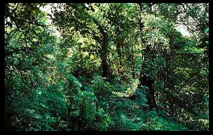
Poona, Maharashtra, India. (Photograph by WWF/Mauri Rautkar)
Introduction The North Western Ghats moist deciduous forests surround the montane rain forest ecoregion (North Western Ghats moist deciduous forests) of the northern areas of the Western Ghats Range and create a conservation landscape from the rich montane rain forests to the lowland moist deciduous forests. Together the two ecoregions vastly increase the conservation potential and importance of the Western Ghats ecosystem. Many of the large herbivores have larger populations in the drier moist deciduous forests, relative to the montane rain forests (although the rain forests have higher endemicity). The populations of predators such as the tigers, leopards, and wild dogs are also correspondingly larger, a response to the greater prey availability.
Location and General Description
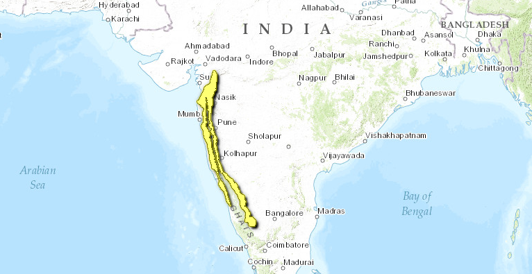
The ecoregion represents the swath of moist deciduous forests around the montane rain forests in the northern section of the Western Ghats Mountains. It extends through Maharashtra and Karnataka States in western India.
 WWF
WWF
The ecoregion has Gondwana origins. During the Cretaceous, the Deccan Plate detached from Gondwanaland and drifted northward to reattach with the northern Eurasian continent. Millions of years later, geological uplift gave rise to the Western Ghats Mountains, which began to intercept the southwestern monsoon rains, creating a moisture gradient from wet conditions in the windward side of the mountains to increasingly dry habitats on the leeward side. Rainfall ranges from 1,500 to 2,000 millimeters (mm) annually, with a 4 to 5 month dry season. Mean annual temperature ranges from 24 to 27°C, but maximum temperatures can exceed a stifling 40°C inland.
The vegetation is influenced by the southwestern monsoon, corresponds to Champion and Seth's southern Indian Moist Deciduous Forest type, and consists of moist, teak-bearing forests, moist mixed deciduous forest without teak, and secondary moist mixed deciduous forests. Characteristic species include Tectona grandis, Grewia tiliaefolia, Lagerstroemia lanceolata, Dillenia pentagyna, Kydia calycina, Bambusa arundinacea, Dalbergia latifolia, Adina cordifolia, Pterocarpus marsupium, Xylia xylocarpa, Wrighia tinctoria, and Schleichera oleosa. The teak forests on lateritic soils have typical understory species represented by Cleistanthus collinus, Holarrherna antidysenterica, Bauhinia racemosa, and Kydia calycina. Important climbers include Ichnocarpus frutescens, Dioscorea spp., Butea superba, Bauhinia vahlii, and Smilax macrophylla.
Patches of evergreen forests extend into these moist deciduous forests, with rain forest species such as Cinnamomum malabaricum, Syzygium gardneri, Mrystica dactyloides, Kneema attenuata, and Diospyros sylvatica.
Biodiversity Features
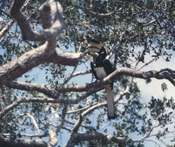 Malabar pied hornbill (Anthracoceros coronatus), India. (Photograph by Rahula Perera)
 The ecoregion harbors eighty-seven mammal species, but unlike in the montane rain forests, none are endemic to this ecoregion. However, several of the mammals in the ecoregion are threatened, including the tiger (Panthera tigris), Asian elephant (Elephas maximus), gaur (Bos gaurus), slender loris (Loris tardigradus), sloth bear (Ursus ursinus), chousinga (Tetracerus quadricornis), and squirrel (Ratufa indica). Tigers used to roam the forests of this habitat, but because of extensive habitat loss (Land-use and land-cover change) and hunting, populations have been severely depleted. The southern section of the ecoregion overlaps with a high-priority TCU and also borders on the Nilgiri Hills, which harbor one of Asia's most important elephant populations.
The bird fauna is much richer, with more than 345 species, including 5 near-endemic species (Table 1) that are shared with the adjacent montane forest ecoregion.
|
Table 1. Endemic and Near-Endemic Bird Species. Family Common Name Species Columbidae Nilgiri wood-pigeon Columba elphinstonii Bucconidae Malabar grey hornbill Ocyceros griseus Pycnonotidae Grey-headed bulbul Pycnonotus priocephalus Timaliidae Rufous babbler Turdoides subrufus Psittacidae Malabar parakeet Psittacula columboides An asterisk signifies that the species' range is limited to this ecoregion. The globally threatened spot-billed pelican (Pelecanus philippensis) and lesser florican (Eupodotis indica) are also part of the ecoregion's bird community. Several hornbills-Malabar grey hornbill (Ocyceros griseus), Indian grey hornbill (Ocyceros birostris), and great hornbill (Buceros bicornis)-that need tall, mature forests for nesting can be used as focal species for conservation management. The ecoregion overlaps with an EBA, Western Ghats, identified by BirdLife International. However, relative to the south Western Ghats, the northern parts of the Western Ghats have been poorly surveyed. (North Western Ghats moist deciduous forests) ==Current Status== More than three-fourths of the natural habitat in this ecoregion has been cleared or converted, and only scattered fragments remain. However, even these fragments represent important habitat for the Indian megafauna, especially as an extension of the montane forest ecoregion and in the context of connectivity with lowland habitats. The thirteen protected areas cover about 2,200 square kilometers (km2), or 5 percent of the ecoregion (Table 2), but most of these protected areas are small, with the average size being only 173 km2. Three of the eight protected areas-Bhadra, Shettihally, Sharavathi Valley-that overlap with the North Western Ghats montane moist forests are more than 500 km2. {| width="640" border="1" cellpadding="1" align="center" ! colspan="3" align="center" | Table 2. WCMC Protected Areas That Overlap with the Ecoregion. Protected Area Area (km2) IUCN Category Bhimashankar [IM0207] 30 IV Schollpaneshwar 330 IV Purna 150 IV Karnala 50 IV Tansa [IM0135] 80 IV Koyna [IM0135] 90 PRO Chandoli [IM0135] 100 IV Cotigao 170 IV Anshi [IM0135] 280 II Bhadra [IM0135] 330 IV Shettihally [IM0135] 280 IV Sharavathi Valley [IM0135] 220 IV Mookambika [IM0135] 140 IV Total 2,250 Ecoregion numbers of protected areas that overlap with additional ecoregions are listed in brackets. (North Western Ghats moist deciduous forests) ==Types and Severity of Threats== Forest clearing (Land-use and land-cover change) and human encroachment remain the biggest threats to this ecoregion's natural habitat and biodiversity. Large areas have already been converted into rubber, tea, and coffee plantations. Because of extensive forest fragmentation, it may not be possible to create additional large protected areas without extensive restoration. Poaching is a serious problem in the ecoregion. The dense human population led to a change in conservation status from endangered to critical. ==Justification of Ecoregion Delineation== In an earlier analysis Rodgers and Panwar placed the Western Ghats Mountain Range into a single biogeographic unit. But Rodgers and Panwar acknowledged that the Western Ghats Mountain Range is too large to represent a single unit for conservation planning and divided the range into northern and southern areas. They used the Wyanad as the boundary, where the southern Cullenia-dominated forests transition into drier northern dipterocarp forests. We also used this transition to make a more explicit division of the Western Ghats into northern and southern [[ecoregion]s]. But in keeping with our rules for representing distinct habitat types within separate ecoregions, we placed the belt of moist deciduous forests that surround the montane rain forests into the North Western Ghats moist deciduous forests. We used the 1,000 meter contour from a digital elevation model (DEM) and MacKinnon's map of original vegetation to define the boundary between the montane rain forests and moist deciduous forests. The outer boundaries, between the dry forests in the Deccan Plateau to the east and the distinctly different lowland moist deciduous forests along the Malabar coast to the west, were defined using MacKinnon's reconstruction of the distribution of the original vegetation types. This ecoregion falls within Udvardy's Malabar rain forest biogeographic province. ==Additional Information on this Ecoregion== * For a shorter summary of this entry, see the WWF WildWorld profile of this ecoregion. * To see the species that live in this ecoregion, including images and threat levels, see the WWF Wildfinder description of this ecoregion. * World Wildlife Fund Homepage |
|---|