North Carolina
Contents
- 1 North Carolina National Estuarine Research Reserve
- 1.1 Introduction The North Carolina Coastal Reserve Program, within the Division of Coastal Management, was authorized by the NC General Assembly in 1989 to protect unique coastal (North Carolina National Estuarine Research Reserve) sites. The program includes the North Carolina National Estuarine Research Reserve, part of the National Estuarine Research Reserve System, which the Division manages in partnership with the National Oceanic and Atmospheric Administration under the Coastal Zone Management Act.
- 1.2 Currituck Banks
- 1.3 Rachel Carson
- 1.4 Masonboro Banks
- 1.5 Zeke’s Island
- 1.6 Research
- 1.7 Monitoring
- 1.8 Partners and Supporters
- 1.9 Further Reading
North Carolina National Estuarine Research Reserve
Introduction The North Carolina Coastal Reserve Program, within the Division of Coastal Management, was authorized by the NC General Assembly in 1989 to protect unique coastal (North Carolina National Estuarine Research Reserve) sites. The program includes the North Carolina National Estuarine Research Reserve, part of the National Estuarine Research Reserve System, which the Division manages in partnership with the National Oceanic and Atmospheric Administration under the Coastal Zone Management Act.
The North Carolina Coastal Reserve is comprised of ten sites. Four of these are designated as the North Carolina National Estuarine Research Reserve. It includes Currituck Banks, Rachel Carson, Masonboro Island, and Zeke’s Island sites. Other sites in the NC Coastal Reserve Program are Kitty Hawk Woods, Emily and Richardson Preyer Buckridge, Buxton Woods, Permuda Island, Bald Head Woods, and Bird Island.
Currituck Banks
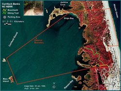 Currituck Banks boundary map. (Source: NOAA)
 The Currituck Banks site is an excellent example of an undisturbed barrier island and low-salinity estuarine system. The site lies in the northeaster corner of North Carolina, 10 miles south of the Virginia border and three-quarters of a mile north of the village of Corolla. Bounded by Currituck Sound and the Atlantic Ocean, the site encompasses 954 acres. The Nature Conservancy and the U. S. Fish and Wildlife Service own neighboring tracts.
Throughout recent geologic time, Currituck Banks has been a dynamic barrier landform, moving or “migrating” in response to sea-level changes. While the Banks was once a series of islands, it is currently part of a complex barrier spit that extends about 70 miles from Virginia Beach to Oregon Inlet. Behind this barrier spit, extensive marshes have built up from inlet deltas and over wash fans that were submerged by rising sea level.
The mixing of warm Gulf Stream currents and cooler northern currents off Currituck Banks creates a climate where northern species reach the southern limit of their ranges and southern species reach the northern limit of their ranges. As a result, a diversity of species from both regions is found here. The habitats are ocean beach, sand dunes, grasslands, shrub thicket, maritime forest, brackish and freshwater marshes, tidal flats and subtidal soft bottoms. The rich resource of commercial and game fish are largemouth bass, yellow perch, tidewater silverside, pumpkinseed, blue-spotted sunfish, bluegill, black crappie and channel catfish. Commercial fish catches also include white perch, carp, shad, herring and eel. Birds found in the area that are of special concern are the osprey, Wilson’s plover, black skimmer and least tern. Currituck Sound is located within the Atlantic Flyway and the site is especially important for migrating waterfowl.
Watershed
The Albermarle Sound is formed by the union of the Roanoke and Chowan rivers. They drain 8,000 and 4,800 square miles respectively. Due to its distance from the ocean, it is generally fresh for most of its length. As freshwater flow reduced due to consecutive years of drought, the salt content has risen. The Pasquotank, Alligator and Scuppernog rivers also empty into the sound before it meets the Currituck Sound.
Biodiversity
Flora: The Currituck Banks area represents a transition between the Virginian and Carolinian biogeographic provinces. Plant species indicative of this change are sea oats (typical of the southern areas) and American beach grass (found to the north and around the great lakes), which grow together on Currituck dunes. General plant communities of the site include grass-dominated dunes, shrub thicket, maritime forest, freshwater marsh, brackish marsh and submerged vegetation in the sound.
Fauna: Currituck is located within the Atlantic Flyway, attracting accipiters, falcons, ducks, geese, warblers, gulls, terns, herons and egrets. Indigo buntings, bobwhites and other mainland species also use the islands for nesting. The site has particular significance with respect to waterfowl. Currituck Sound harbors an estimated six percent of the Atlantic Flyway overwintering waterfowl population and 32 percent of North Carolina's wintering fowl. Typical types of waterfowl include dabbling ducks, diving ducks, geese, swans and coots.
Currituck Sound contains a rich resource of forage, commercial and game fish. Largemouth bass, yellow perch, striped bass, tidewater silverside and pumpkinseed fish are the ecologically dominant species. Other game fish found in the area include white perch, bluegill, black crappie, chain pickerel and channel catfish. Carp, shad, herring and eels are also found in the area. Mammals include muskrats, river otters and minks, as well as deer, gray foxes, raccoons, opossums, nutrias and feral hogs. Occasionally, feral horses graze or pass through the site. Mole crabs, ghost crabs and coquina clams among other invertebrates are common in the site's intertidal zone. Common fish include striped bass, bluefish, mullet, croaker, spot and weakfish.
Endangered Species: Four federally-listed threatened or endangered species and 63 species recognized by state biologists as endangered, threatened or of special concern are found at this site. Bald eagles and piping plovers are seen occasionally, but are not known to nest in the area. Peregrine falcons migrate through the Banks in the fall. Scattered nest sites for loggerhead turtles, federally-protected, threatened reptiles, are also found in the Currituck Banks site.
Tidal Range and River Flow
There is an occasional direct overwash from the Atlantic Ocean during major storms. Currituck Sound is brackish due to its distance from an ocean inlet. Currituck Sound receives no direct input from a freshwater river.
Soil Types
Soils are composed of sediments that have not been weathered to the extent that distinct horizons are present in the profiles. The dunes and beach areas of the component consist of excessively well-drained sands of the Newhan series. Back dunes, shrub thicket and maritime forest occur over the slightly moister and low-lying sands of the Duckston and Corolla series. Marshes and seasonal ponds of the component are associated with the poorly-drained sands of the Currituck series that is characterized by a shallow, mucky peat surface layer.
Geology
Currituck Banks separate Currituck Sound from the Atlantic Ocean. Through recent geologic time, these banks have been an unstable, migratory barrier land form, consisting of Holocene and Pleistocene sediments (primarily sand) that shift in response to changes in sea level. Though the banks were previously a series of islands, they are now part of a complex barrier spit that extends about 70 miles from Virginia Beach to Oregon Inlet.
Rachel Carson
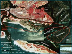 Rachel Carson boundary map. (Source: NOAA)
 Across Taylor’s Creek from the Beaufort waterfront is a complex of islands that compose the Rachel Carson site. The islands at the western end of the site—Carrot Island, Town Marsh, Bird Shoal, and Horse Island—are more than three miles long and less than a mile wide, covering 2,025 acres. Middle Marsh, separated from the rest of the site by the North River Channel, is almost two miles long and less than a mile wide, covering nearly 650 acres.
The Rachel Carson site is in the midst of one of the state’s fastest growing areas. The area is also a center of marine research and education. The marine laboratories of Duke University, University of North Carolina, and North Carolina State University are located here, as is a regional office of the National Oceanic and Atmospheric Administration, National Marine Fisheries Services and the North Carolina Division of Marine Fisheries.
The islands and estuarine waters at the Rachel Carson site are strongly influenced by river and inlet dynamics and the twice-daily tides. The range of tidal changes at Middle Marsh, the low-salinity variation of the western section, and topography of the entire site have created a diverse and productive estuarine system. Habitats found within the site are tidal flats, flooded salt marshes, ocean beach, subtidal soft bottoms, hard surfaces, dredge spoil areas, sand dunes, shrub thicket and maritime forest. More than 200 species of birds have been observed at the site, which is located within the Atlantic Flyway. Twenty-three species are considered rare or decreasing in number. The site is an important feeding area for Wilson’s plovers in the summer and piping plovers in the winter. The shrub thicket of Middle Marsh supports an egret and heron rookery. In addition to feral horses, the river otter, gray fox, raccoon and marsh rabbit inhabit the islands. The American bottlenose dolphin swims in the deep waters around the islands, along with fifty-two species of fish. Forty-seven invertebrate species common to the site include mollusks and worms.
Watershed
The Rachel Carson component is located between the Newport and North rivers and receives fresh water from both. Officially the Rachel Carson is located within the White Oak watershed, although there is no direct impact from the White Oak River.
Biodiversity
Flora: The dominant low salt marsh is colonized by salt marsh cordgrass, while high marsh typically contains a mixture of saltmeadow hay, sea ox-eye and black needlerush. Weedy asters, grasses, vines and shrubs occupy successional communities on the numerous spoil areas along Taylor's Creek. A small area of maritime forest and shrub thicket on the east end of Carrot Island is dominated by live oak, loblolly pine, red cedar, yaupon and wax myrtle.
Fauna: Over 200 species of birds have been observed within the component area. The site is located within the Atlantic Flyway and is an important feeding area for Wilson's plovers in the summer and piping plovers in the winter. The shrub thicket of Middle Marshes support egret and heron rookeries. River otters, gray foxes, raccoons, marsh rabbits and feral horses inhabit the islands. American bottlenose dolphins swim in the channels and creeks, along with over 50 species of fish. Invertebrate species common to the site include various bivalves and whelks.
Endangered Species: Peregrine falcons have been observed on the Reserve component. The site also serves as an important feeding place for the piping plover (federal threatened status) and Wilson's plovers, both listed by state biologists as species of special concern. Loggerhead sea turtles (federal threatened status) occasionally nest on Bird Shoal.
Tidal Range and River Flow
Tides are semi-diurnal and in the mesotidal range (less than six feet or less than 2 meters). Rachel Carson component is located between the Newport and North rivers and receives fresh water from both.
Geology and Soil Types
The islands and intertidal flats composing the component consist of Recent and Pleistocene sediments including sands, silts and clays of the Pamlico Terrace. The component is not a barrier island system as such, but includes islands and shoals that developed behind the barriers of Shackleford Banks and Bogue Banks.
The soils of the component include primarily sandy profiles of such recent development that diagnostic profiles are not present. Natural dunes, beaches and vegetated spoil areas and a limited area of natural shrub thicket and maritime forest of the component are classified in the extensively-drained Newhan series. Inter- and supratidal marshes grow in the poorly-drained sand and muck of the Carteret series.
Cultural History
Before the European colonization of America, Carrot Island and Middle Marsh may have been used intermittently by the Coree Indians. European settlement of the Beaufort area began in the first two decades of the eighteenth century. In 1723, the town began to sell lots and Beaufort developed as a port. In 1782, a Revolutionary War skirmish near the mouth of Taylor's Creek began a short-term British occupation of Beaufort. Mullet and other fish were caught by a fishery on Carrot Island and processed for sale in Beaufort. It was also a center for Menhaden processing with only one plant remaining. However, Beaufort began to decline as a port in the 1850s. Currently Beaufort is becoming a resort area.
Masonboro Banks
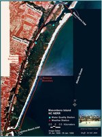 Masonboro Island boundary map. (Source: NOAA)
 The largest undisturbed barrier island along the southern part of the North Carolina coast is Masonboro Island, located approximately five miles southeast of Wilmington. The Masonboro site is bounded by the Atlantic Ocean to the east, the Atlantic Intracoastal Waterway to the west, Masonboro Inlet to the north and Carolina Beach Inlet to the south.
The 8.4-mile-long island encompasses approximately 5,046 acres, 87 percent of which are covered with marsh and tidal flats. The remaining 619 acres are composed of beach uplands and dredge material islands. The island is located in the most populous part of the North Carolina coastal area.
Masonboro Island is an essentially pristine barrier island and estuarine system. The various salinity patterns found in the extensive subtidal and intertidal areas along the sound side of the island support a myriad of estuarine species. The habitats found within the reserve site include subtidal soft bottoms, tidal flats, hard surfaces, salt marshes, shrub thicket, maritime forest, dredge spoil areas, grasslands, ocean beach and sand dunes. Loggerhead and green sea turtles nest on the beaches, where seabeach amaranth plants grow on the foredunes. All of these species are listed as threatened by the Federal Government. Of concern are the black skimmers, Wilson's plovers and least terns that nest on the island. Sound sediments are home to two state watch list species—Hartman's Echiurid and a polycheate worm in the genus Notomastus. The nutrient-rich water of Masonboro Sound is an important nursery area for spot, mullet, summer flounder, pompano, menhaden, and bluefish.
Habitat
Habitats include isolated eelgrass bed, subtidal softbottoms, intertidal mud and sand flats, regularly-flooded (low) salt marshes, irregularly-flooded (high) salt marshes, shrub thicket, maritime forest, dredge materials and spoil areas, dunes or grasslands and ocean beach.
Watershed
The Cape Fear estuary drains the largest watershed in North Carolina, containing 27 percent of the state's population. The Cape Fear River itself (about 320 km in length) is formed in the Piedmont province by the confluence of the Haw and Deep Rivers in Chatham County. It is joined by two tributaries just upstream of Wilmington: the Black River and the Northeast Cape Fear River. The Black River drainage represents about 17 percent of the Cape Fear drainage system and the Northeast Cape Fear River about 18 percent.
Biodiversity
Flora: Dunes are covered by sea oats, panic grasses, seaside spurge and sea rocket. Seaside evening primrose, prickly pear and gaillardia grow behind the ocean dunes. Slightly higher sandy areas are covered by shrub thicket characterized by wax myrtle, silverling, red cedar, yaupon and Hercules' club. Isolated maritime forest hammocks are located where inundation by storm tides is very rare. Live oak, loblolly pine and red cedar trees, plus an understory of shrub thicket species, are typically found in this community. Marsh areas are dominated by saltmarsh cordgrass in low marsh areas, while high marsh is covered by a mixture of species including sea ox-eye, black needlerush, saltmeadow cordgrass and sea lavender.
Fauna: Nearshore waters are frequented by brown pelicans, shearwaters, royal terns, herring gulls and laughing gulls. The intertidal beach zone serves as a resting and feeding area for sand pipers and plovers. Mourning doves, ground doves, and common nighthawks nest and feed within the dune areas, while boat-tailed grackles and red-winged blackbirds feed on seed oat seeds in the fall. Seasonal nesters include black skimmers, night hawks and American oystercatchers. Other birds include warblers and sparrows, great blue and little blue herons, tricolor herons, snowy egrets, great egrets, willets and clapper rails.
Forty-four species of fish have been collected from the waters of this site, including spot, mullet, summer flounder, pompano, menhaden, bluefish, striped killfish, mummichog, pinfish, silversides and sheepshead minnow. Mammals on the island include cotton rats, house mice, marsh rabbits, opossums, raccoons and river otters. Invertebrate residents of the intertidal mud and sand flats include various mollusks: quahog clams, marsh razor clams, oysters and mud snails.
Endangered Species: Four animal species found at the Masonboro Island site are recognized as endangered or threatened by the federal government. Peregrine falcons (endangered) have been reported as rare seasonal transients. Piping plovers (threatened) feed on the island during the winter. Loggerhead and Green sea turtles nest on Masonboro Island ocean beach. Sea beach amaranth is present in the foredunes and upper beach.
Tidal Range and River Flow
Tides are semi-diurnal and usually fluctuate approximately 3.8 feet (1.2 meters), while spring tides average 4.5 feet (1.4 meters). Masonboro Sound and Myrtle Grove Sound receive no direct input from a freshwater river.
Geology and Soil Types
The Masonboro component consists of recent and Pleistocene sediments that are part of the Pamlico Terrace on the eastern edge of the North Carolina coastal plain. Masonboro Island is the present-day counterpart of a barrier island complex formed some distance offshore, the time being rather speculative. However, the genesis of the original island is thought to have occurred by mainland beach detachment, occurring sometime in the last 5,000 years, when the Holocene sea rise slowed down.
Three series have been mapped on Masonboro Island: Carteret, Duckston and Newhan. The Carteret series underlies the tidal marshes. The poorly-drained sands of the Duckston series are found within the shrub thicket and maritime forest communities. Dune and grassland areas along the side of the island are underlain by excessively to somewhat excessively well-drained soils of the Newhan series.
Cultural History
Giozanni Verrazzano, on an expedition sponsored by Francis I of France in 1542, may have described Masonboro Island. The mainland shore of the area was settled during the second quarter of the 18th century by farmers and fishermen. More affluent landowners established summer residences. Confederate troops were stationed along the mainland shore, particularly near Whiskey Creek, the largest saltworks in the area. It was destroyed by Union troops in 1864. The island and sound were involved in the wrecks of at least four vessels during the course of the war. During the last half of the 19th century and the beginning of the 20th, the most important fisheries of the area were mullet, flounders, shrimps, clams and oysters. Since the completion of the Atlantic Intracoastal Waterway in 1932, the area has been developed as a resort destination.
Zeke’s Island
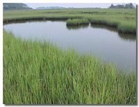
The site is 22 miles south of Wilmington, bounded by Federal Point to the north, Smith Island to the south, the Atlantic Ocean to the east, and the Cape Fear River to the west.
The lagoon-like complex at the Zeke’s Island site is one of the most unusual areas of the North Carolina coast. There are 3 main islands within the site: Zeke’s Island covering 42 acres of high ground, North Island encompassing 138 upland acres, No Name Island covering about three acres and the beach barrier spit of 64 acres. The islands are fringed with extensive marshes and tidal flats.
While shoals and marshes have continued to appear and disappear in the Basin, the main island of the site—Zeke’s, No Name, and North—have remained stable relative to the sixty-six-acre barrier spit, even though their shorelines periodically increase and erode. Zeke’s and No Name Island have elevations of only a few feet; North Island has several scattered dune systems, one of which reaches to twenty feet above sea level. The unusual characteristics of the site have created a variety of habitats, including tidal flats, salt marshes, shrub thicket, maritime forest, sand dunes, ocean beach and the hard surface of the rocks. Beach amaranth has been found on the site’s foredune areas. Fish, shrimp, crabs, clams and oysters use the estuary as a nursery ground. Both the Atlantic loggerhead and green sea turtles, federally-protected threatened species, occasionally nest on the site’s open beaches. The expanse of intertidal flats in the Zeke’s Island vicinity is the single most important shorebird habitat in southeastern North Carolina. Dunlin, black-bellied plovers, short-billed dowitchers, white ibis, great blue herons as well as black ducks, mallards and pintails have been recorded there.
Watershed
Zeke's Island is part of the lower Cape Fear region, an area whose outstanding estuarine and oceans resources have long-supported an important commercial fishing industry. The Cape Fear estuary drains the largest watershed in North Carolina, containing 27 percent of the state's population. The Cape Fear River itself (about 320 km in length) is formed in the Piedmont province by the confluence of the Haw and Deep rivers in Chatham County. It is joined by two tributaries just upstream of Wilmington, the Black River and the Northeast Cape Fear River. The Black River drainage represents about 17 percent of the Cape Fear drainage system and the Northeast Cape Fear River about 18 percent.
Biodiversity
Flora: Dunes dominated by sea oats occur from the upper beach drift line back to the secondary dunes where they mix with other grasses (e.g. saltmeadow cordgrass, panic grass) and forbs (e.g. seaside goldenrod, spurge, gaillardia, sand primrose) to form a stable grassland. Shrub thicket and maritime forest consisting of live oak, loblolly pine, wax myrtle, yaupon and red cedar occur where salt spray and sea water flooding do not prohibit woody plant growth. The site's extensive salt marshes are dominated by a mixture of saltmarsh cordgrass, salt grass, black needlerush, sea ox-eye, glasswort and sea lavender.
Fauna: Fishes, shrimp, crabs, clams and oysters use the estuary as a nursery ground. Atlantic loggerhead sea turtles occasionally nest on the site's ocean beach. The expanse of intertidal flats in the Zeke's Island area is one of the most important shorebird habitats in southeastern North Carolina. Species sighted include: dunlins, black-bellied plovers, short-billed dowitchers, white ibises, great blue herons, snowy egrets, Louisiana herons, black ducks mallards and pintails. Mammals observed include opossums, grey foxes, marsh rabbits and cotton rats.
Endangered Species: Seabeach Amaranth, a species with federal threatened status, occurs on upper beaches and foredunes of the Zeke's Island component of the reserve. Atlantic loggerhead turtles (federal threatened status) occasionally nest on the site's ocean beach. Other threatened or endangered fauna reported at the site include bald eagles and piping plovers.
Tidal Range and River Flow
Regular ocean tides through New Inlet occur. The semi-diurnal tide range is up to six feet (or two meters). The Cape Fear River flows irregularly through the degraded jetty and overwashes the jetty during extremely high tides.
Geology and Soil Types
The area is composed of recent and Pleistocene sediments (up to one million years old) situated on the Pamlico Terrace of the North Carolina coastal plain. The varying combinations of sand, silt and clay are derived from both marine and terrestrial origins.
Soils of the component exhibit little horizon development and thus reflect the relatively young age of the sediments. Beach and dune areas are classified in the Newhan-Corolla association and consist of porous sands that are excessively well-drained and low in nutrients. The Duckston series is found in dune flats and drainage swells is similar in profile to the previous soils, but occurs nearer to the water table. Poorly-drained sands mixed with organic matter in the intertidal and subtidal marshes are classified in the Carteret series.
Research
The North Carolina National Estuarine Research Reserve encourages researchers from universities and government laboratories to use the four sites for short- or long-term investigations that will promote better understanding and management of estuaries. Data from monitoring stations, an annotated bibliography of work done on each site, species lists and GIS maps are offered to participating investigators. Projects have been completed on such diverse topics as estuarine eutrophication, productivity of benthic microalgae, use of dredge material to renourish salt marshes and effects of feral horses on salt marsh productivity.
The Graduate Fellows Program of the National Estuarine Research Reserve System fosters graduate student use of the reserves for their research projects. Fellows then contribute to other current reserve programs.
The research office initiates and conducts research into the dynamics of estuaries. Two ongoing projects are: 1) a Habitat Assessment Tool that can gather water quality data for a large body of water by the use of a towed instrument; and 2) the National Telemetry Project that will provide real-time weather and water quality data accessibility throughout the National Estuarine Research Reserve System.
Monitoring
 Zeke’s Island boundary map. (Source: NOAA)
 In an effort to learn more about the natural character of these estuaries, the reserve operates water quality monitoring stations at the Rachel Carson, Masonboro and Zeke's Island components of the reserve. Automated weather stations have been established within Rachel Carson and Masonboro Island.
The North Carolina National Estuarine Research Reserve monitoring program follows protocols developed for the NERRS System-Wide Monitoring Program. The ultimate goal is to identify and track long-term changes in the status, integrity and biological diversity of estuaries. Every 30 minutes, water quality meters deployed within the Rachel Carson, Masonboro Island and Zeke’s Island sites sample such parameters as: salinity, water temperature, pH, turbidity, dissolved oxygen, conductivity, depth and chlorophyll a. Weather stations at both Rachel Carson and Masonboro Island provide hourly data on air temperature, barometric pressure, precipitation, wind velocity, relative humidity and solar radiation. Monthly nutrient samples are also collected and analyzed. All of these data are cataloged and maintained both at the Reserve office and at the Centralized Data Management Office within the University of South Carolina Baruch Marine Laboratory in Georgetown, SC. Future directions of the monitoring program will include biological communities/habitats and land-use changes within watersheds.
Partners and Supporters
The reserve is managed by the North Carolina Department of Environment and Natural Resources, Division of Coastal Zone Management, as part of the state’s Coastal Reserve Program. The Coastal Reserve has 15 employees located in offices at Kitty Hawk, Columbia, Beaufort and Wilmington. In addition to the four North Carolina Reserve sites, staff also oversees six other [[coast]al] natural areas that are managed for the same goals of research, education and compatible public uses.
Given the complexity of the program, various partnerships and committees have been developed to assist in implementation of the North Carolina Reserve management plan. The reserve is affiliated with University of North Carolina at Wilmington, Duke University Marine Laboratory and a wide network of federal, state and local partners. Each component has a 10- to 15-member local advisory committee that provides input for stewardship issues and helps with volunteer projects. The Carolina Estuarine Reserve Foundation, a non-profit friends group for all ten sites, has been created to further the state program mission.
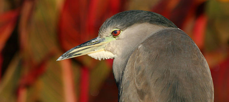 Image Source: Wikimedia Commons
Further Reading
| Disclaimer: This article is taken wholly from, or contains information that was originally published by, the National Oceanic and Atmospheric Administration. Topic editors and authors for the Encyclopedia of Earth may have edited its content or added new information. The use of information from the National Oceanic and Atmospheric Administration should not be construed as support for or endorsement by that organization for any new information added by EoE personnel, or for any editing of the original content. |