Navassa Island
| Topics: |
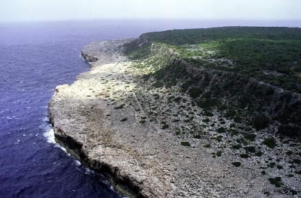
Aerial photo of the east coast of Navassa Island, looking south. Source: US Geological Survey
Countries and Regions of the World Collection  Navassa is an uninhabited, 5 km² island in the Caribbean Sea, 35 miles west of Tiburon Peninsula of Haiti (between Haiti and Jamaica) administered by the U.S. Department of Interior. Navassa Island is an uninhabited island in the It is an unorganized, unincorporated territory of the US.
It is mostly exposed rock with numerous solution holes (limestone sinkholes) but with enough grassland to support goat herds. There are dense stands of fig trees, and scattered cactus.

Geology
Ancient coral reef sediments that have been raised above sea level by vertical movements of the earth's crust underlie Navassa. Navassa may have formed as a small coral atoll, but at the close of the Miocene Period about 5 million years ago, these reefs began to emerge. Emergence resulted in the alteration of calcium carbonate sediments (aragonite) to calcium-magnesium carbonate rock (dolomite), the formation of a terrace around the island, and the beginnings of chemical weathering and cave formation.
About two million years ago phosphate-rich sediment was deposited on the island, perhaps guano that was greatly altered to form the mineral phosphate deposit now found on the surface. The oolitic phosphate forms a thin veneer overlying and filling karst holes in the dolomite.
History
In 1857, the phosphorite on Navassa was mistaken for guano by a U.S. sea captain who laid claim to the island under the Guano Island Act passed by the U.S. Congress in 1855.
Between 1865 and 1898 almost a million tons of the phosphorite were strip-mined from the island and shipped to Baltimore by the Navassa Phosphate Co.
The island was abandoned during the Spanish American War, but by that time it was firmly established as US territory.
The opening of the Panama Canal put Navassa in the middle of the traffic lanes between the Atlantic and Caribbean, and the Coast Guard built Navassa Island Light, a 46-meter-tall lighthouse on the southern side of the island in 1917.
Global Positioning Systems eliminated the need for the lighthouse by 1996, and the Coast Guard turned Navassa over to U.S. Department of Interior on January 16, 1997.
A 1998 scientific expedition to the island described it as a unique preserve of Caribbean biodiversity; the following year it became a National Wildlife Refuge and annual scientific expeditions have continued.
It has a strategic location 160 km south of the US Naval Base at Guantanamo Bay, Cuba. 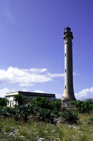 Source: USGS
Subsistence fishing and commercial trawling occur within refuge waters. Transient Haitian fishermen and others camp on the island.
The island is claimed by Haiti,
Ecology and Biodiversity
The biological diversity of the island and the fact that Navassa is U.S. territory owe much to the geology of the island. The limestone island is an uplifted atoll in the range of 5 million years old, giving rise to a biota that has been isolated long enough have evolved independently of the biota on surrounding land masses. 10-30m cliffs surround Navassa, making it difficult for organisms to reach the island's high terraces. Surrounding waters are 500 m deep, eliminating the possibility of land connections to larger islands during Pleistocene sea-level lowstands.
Fifteen island species are currently recognized as endemic and include land snails, lizards, vascular plants, and possibly a ground dove. Two endemic species, an iguana and curly tailed lizard found on the island during the last century, could not be located and may be extinct. Common on the island as late as 1928, only one specimen of the palm tree Pseudopheonix sargentti saonae var. navassana remains.
Basic Facts
Location: Caribbean, island in the Caribbean Sea, 35 miles west of Tiburon Peninsula of Haiti
Geographic Coordinates: 18 25 N, 75 02 W
Area: 5.4 sq km
Coastline: 8 km
Maritime Claims:
Natural Hazards: hurricanes
Terrain: raised coral and limestone plateau, flat to undulating; ringed by vertical white cliffs (9 to 15 m high). The highest point is an unnamed elevation on southwest side (77 m).
Climate: marine, tropical.
Dependency Status: unorganized, unincorporated territory of the US; administered by the Fish and Wildlife Service, US Department of the Interior from the Caribbean Islands National Wildlife Refuge in Boqueron, Puerto Rico. There has also been a private claim advanced against the island
Legal System: accepts compulsory International Court of Justice (ICJ) jurisdiction; and accepts International criminal court (ICCt) jurisdiction
Natural Resources: guano
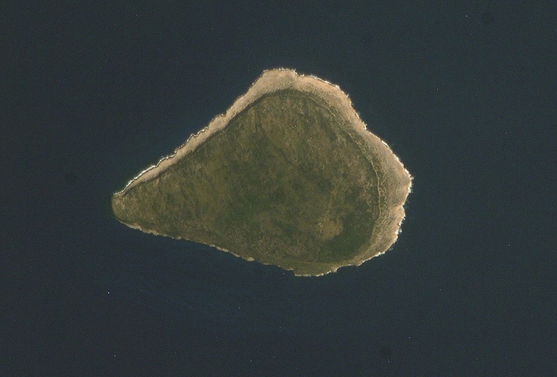
NASA atronaut image of Navassa Island, Caribbean Sea.
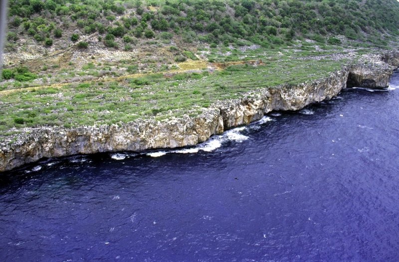
Aerial photo of the southwest coast of Navassa Island in the Caribbean Sea. Source: USGS