Marin Hills and Valleys
The Marin Hills and Valleys subsection is a geographic area set on mountainous terrain between San Francisco Bay and the San Andreas Fault north of the Golden Gate in California. The climate is temperate and humid, with substantial marine influence on climate, particularly on the south and west sides of the subsection. The area was first settled by humans in the mid Holocene, but significant alteration of the landscape appeared beginning in the mid 19th century with arrival of large numbers of European settlers. This subsection is accorded the geographical descriptor MLRA 15c.
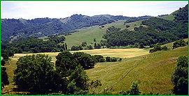 Hicks Valley area northwest of Novato, Source: Charles B. Goudey
Contents
Lithology and stratigraphy
This subsection is dominated by Franciscan sedimentary, minor volcanic, and metamorphic rocks of the Central, Coastal, and Eastern Belts. Most of them are intensely deformed. The Franciscan strata are poorly dated, but they range from Jurassic through Cretaceous, and in the Coastal Belt, into the early Tertiary. Ultramafic rocks are scattered through the Franciscan Complex. There are small areas of Pliocene andesite on the northeast, opposite the Sonoma volcanics, and recent alluvium.
Geomorphology
This is a subsection of mountains and hills with rounded ridges, steep and moderately steep sides, and narrow canyons. Most of the mountains are elongated in north-northwest to northwest directions, although Mount Tamalpais is oriented southwest-northeast. The elevation ranges from sea-level up to 2604 feet on Mount Tamalpais. Mass wasting and fluvial erosion are the main geomorphic processes.
Soils
The soils are mostly Typic Haploxerolls, Entic Haploxerolls, and Ultic Argixerolls, and, in the southwestern part of the subsection, Lithic Haplustolls and Typic and Pachic Argiustolls. The soil temperature regimes are mostly mesic and thermic, and in the southwestern part of the subsection, isomesic. Soil moisture regimes are mostly xeric and, in the southwestern part of the subsection, ustic. Udic soil moisture regimes are common on the lower slopes in steep canyons.
 Tidal salt marsh, Marin County. Source: James R. Nelson
 Vegetation
The natural plant communities, from isomesic and udic to thermic and xeric soil temperature and moisture regimes, are mainly Redwood series, Douglas-fir - tanoak series, and Coast Live Oak series. Grasslands are predominantly California oatgrass series or Pacific reedgrass series in the southwestern part and needlegrass grasslands in the remainder of the subsection. Chamise series is present on shallow soils, particularly on rocky south and west facing slopes and certain ridgetops.
Characteristic vegetative series by lifeform include:
- Grasslands: California annual grassland series, Foothill needlegrass series, Introduced perennial grassland series, Pacific reedgrass series, Purple needlegrass series.
- Shrublands: Chamise series, Leather oak series.
- Forests and woodlands: Bishop pine series, Black oak series, California bay series, Coast live oak series, Douglas-fir - tanoak series, Mixed oak series, Redwood series, Sergeant Cypress series, Tanoak series, Valley Oak series.
The Marin Hills and Valleys have a diverse flora, partially enabled by the wide variety of forest, grassland and chaparral habitats;[1] moreover, there are a significant number of local endemic plants.
Climate
The mean annual precipitation is about 20 to 60 inches; there is considerable summer fog attributable to the proximity of the Pacific Ocean. Mean annual temperature is about 50° to 59° Fahrenheit. The mean freeze-free period is about 250 to 300 days.
Surface water
Surface water runs off rapidly, and most of the minor streams are dry by the end of the summer, except in the southwestern part of the subsection. There are no natural ponds or lakes in the subsection, but several reservoirs developed to support agriculture and the human population that burgeoned in this region since 1850 AD. Some of the streamflow discharges to the Pacific Ocean, but west of the main ridge crest, flows drain to the San Francisco Bay.
Archaeology
Prominent early inhabitants of the Marin Hills and Valleys were the Native American Miwoks. In addition to subsistence living from the San Francisco Bay shoreline resources, the Miwoks exploited the oak forests by harvesting and grinding acorns. This people also left significant archaeological records in the form of rock carvings and stone mortar beds, notably on Ring Mountain of Marin County.[2]
Return to Northern California Coast